

Ardverikie and Loch Laggan Munros
Bike and hike over Beinn a’ Chlachair, Geal Chàrn and Creag Pitridh, the three Munros of the wild Ardverikie Forest between Laggan and Alder.
Route outline
| Munros | ||||
| Walk ascent | 1200m (3930ft) | |||
| distance | 15km (9m) | |||
| time | 6:00hr | |||
| Bike ascent | 150m (490ft) | |||
| distance | 11km (7m) | |||
| time | 1:00hr | |||
| Start/finish | Luiblea, Glen Spean Grid Ref : NN432830 | |||
| Terrain |
| |||
| Nav |
| |||
| Effort |
| |||
| Scenery |
| |||


The Ardverikie Munros lie in a fairly compact group with good tracks and paths linking the ground below them. Creag Pitridh is a rough little hill, linked to much larger Geal Chàrn via a grassy col with a re-ascent of only 100m. Beinn a' Chlachair is the dominant mountain in the group - vast, complex, fairly pathless and requires respect when mist is down !
The track in from Luiblea is suitable for cycling (mountain-bike recommended, but a hybrid bike will probably cope) and will considerably cut down on tìme needed, the return free-wheel is a hoot ! Higher up, the vast plateaux of Geal Chàrn and Beinn a'Chlachair will test navigation skills in mist and white-out conditions !
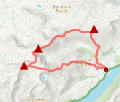
Show map

Route description
1. Getting to the start by Luiblea

Reaching Lochn na h-Earba by bike
The route starts by Luiblea, from a long lay-by on the A86, 22km east of Spean Bridge.
Although there is plenty parking available, this is a popular group of hills and the lay-by can be full early on.
More parking is available 300m west of the track access.
2. Lochan na h-Earba

Beinn a' Chlachair from by Lochan na h-Earba
From the roadside, head over the bridge over the River Spean to a junction in the track  , turn left and through a deer-fence. The track continues for 1km up to some forestry and another junction
  - turn sharp right.
Bike up another 1.5km to another junction  beside a reservoir - this tìme keep on the main track and continue up to the bridge by Lochan na h-Earba
  . In summer this is a beautiful place to stop for a bit - the beach over the bridge seems quite exotic and strangely somewhat out of place. Cross the bridge and head for around 200m to where a small cairn denotes the start of the stalker's path
  . Leave bikes by this cairn (e-bikes will get further uphill).
3. Beinn a' Chlachair

Heading up Beinn a' Chlachair
Head up the stalkers path for around 1km, then leave the path and cross the Allt Coire Pitridh (which should be relatively straightforward). Now on pathless tussocky ground head due south and aim for the eastern rim of Coire Mòr Chlachair. The ground gets steeper and heathery. As it starts to level out, the wind has stunted the heather and going underfoot becomes easier.
Once on the plateau  , head south-west over grassy ground with obvious path around Coire Mòr Chlachair to reach more bouldery ground for the final climb to the summit of Beinn a' Chlachair
  with its large cairn. Fine views in all direction from this summit.
4. Geal Chàrn

Creag Pitridh and Geal Chàrn from the top of the stalker's path
If in mist, your navigation and timing will now be put to test. If not in mist, the route is obvious !
Leave Beinn a' Chlachair's cairn and return to the plateau south of Coire Mòr Chlachair .
Follow the path (very faint in bits) north-east around Coire Beag a'Chlachair and climb up the east top  , marked 972m on OS maps.
North-east again, gradually dropping height, a small burn is picked up just before the ground ahead starts to drop steeply away. A small cairn  marks the start of the route down, which is not very obvious, but worn sections of path can be picked out that zig-zag around the crags down to the stalker's path below.
Use the stalkers path to cross the bealach and start climbing north. Once the ground on the right starts to look a bit drier, leave the path and aim north-east up Geal Chàrn.
Further up, don't stick to the bouldery crest, keep on the east side where the ground is grass covered and much easier underfoot.
The summit plateau of Geal Chàrn is reached and the large cairn marking the top  can be seen ahead. The views are excellent and slightly better than that seen from the hulk of Beinn a'Chlachair. There's even a cylindrical trig point - perfect for balancing a camera ontop of for a group photo !
5. Creag Pitridh

On Creag Pitridh's summit with Geal Chàrn beyond
Return along Geal Chàrn's bouldery crest for 300m, then start to drop westwards on grassy ground. Creag Pitridh is seen ahead, looking fairly insignificant compared to the other Munros around.
Drop to the bealach between Creag Pitridh and Geal Charn, there's no obvious path to follow. On approaching the bealach, a stalkers path  is crossed and a fainter path is picked up to cross the bealach. This path continues up the south-east side of Creag Pitridh, zig-zagging to avoid some slabs to reach the bouldery summit
  .
.
6. Return to Luiblea

Freewheeling back to Luiblea, Beinn a'Chlachair behind
From Creag Pitridh's summit, head south-west initially following a path. The path disappears quite quickly into long grass and boulders, but lower down the ground is just perfect for running quickly downhill !
Further down a faint path can be traced, which meets up with the main stalkers path at the junction of the burns  .
.
Once onto the path return to your bike and head back to Luiblea.
Route profile »

Maps and GPX downloads »


|
Download GPX of route |

|
Open route in OS Maps |
The map images above link to items on Amazon. A small commission is earned on any map purchased which helps fund the operating costs of this website.
Weather forecasts »
| Regional | MWIS - Western Highlands |
| Peak specific | Mountain Forecast.com Met Office YR.no |
| Seasonal | SAIS - Creag Meagaidh Midge forecast |
Alternative and nearby routes »
Binnein Shuas and Binnein Shios | |

|
A fine hillwalk above Loch Laggan combining Binnein Shuas’s rugged summit with the gentler grassy dome of Binnein Shios in a quiet, scenic circuit. Peaks : 2 Fionas
Ascent : 975m (3200ft) Distance : 20km (12m) Time : 6:40hr |
Creag Meagaidh and neighbouring Munros | |
|
Circular hillwalking route up Creag Meagaidh via Càrn Liath and Stob Poite Coire Ardair, returning down the skyline or through ‘The Window’. Peaks : 3 Munros
Ascent : 1200m (3940ft) Distance : 19km (12m) Time : 6:45hr |
The Fara and Meall nan Eagan | |
|
This Dalwhinnie hillwalking circuit leads to The Fara’s large summit cairn and superb views and also takes in nearby Graham, Meall nan Eagan. Peaks : 1 Corbett, 1 Fiona
Ascent : 550m (1800ft) Distance : 11km (7m) Time : 3:40hr |
Geal-Chàrn via the Lancet Edge | |

|
Hillwalking route from Culra via the Lancet Edge up Geal-Charn, then over Beinn Eibhinn, Càrn Dearg and Aonach Beag on a fine linear ridge. Peaks : 4 Munros
Ascent : 1330m (4360ft) Distance : 44km (27m) Time : 6:30hr |
Ben Alder Forest Munros | |

|
Bike and hike from Dalwhinnie into Ben Alder Forest, cycling Loch Ericht then bagging 6 Munros on high plateaux, ridges and lochans from Culra. Peaks : 6 Munros
Ascent : 2400m (7870ft) Distance : 56km (35m) Time : 11:5hr |


