
Coulin Forest from Strath Carron
Hillwalking route up Beinn Liath Mhòr, Sgòrr Ruadh and Fuar Tholl from Achnashellach. A rugged circular with the option to extend to Maol Chean-dearg.
Route outline
| Munros | ||||
| Corbetts | ||||
| Ascent | 1750m (5740ft) | |||
| Distance | 21km (13m) | |||
| Time | 8:10hr | |||
| Start/finish | Achnashellach Halt, Strathcarron Grid Ref : NH005440 | |||
| Terrain |
| |||
| Nav |
| |||
| Effort |
| |||
| Scenery |
| |||


The rugged Munro peaks of Beinn Liath Mhòr and Sgòrr Ruadh encircle Coire Lair in the area known as Coulin Forest overlooking Strath Carron.
An approach from Achnashellach in Strath Carron follows fine stalkers paths and rights-of-way into the area. Higher up, rocky crests are traversed and some easy scrambling is required to negotiate some steep short sections.
The circular route can be varied on approach, or extended to hike up nearby Fuar Tholl or Maol Chean-dearg.
Show map

Route description
1. Getting to Achnashellach

Achnashellach rail halt
The route begins from Achnashellach which is on a single track section of the A890, around halfway between the villages of Lochcarron and Achnasheen.
There is an old red phone box, by the roadside, just along from where there is parking for around 10 cars.
There is also a rail halt at Achnashellach on the Inverness-to-Kyle of Lochalsh line.
If the intention is to extend the route over to Maol Chean-Dearg, then it would be advisable to drop a bike at Coulags or arrange other transport so as to avoid a 7km walk back along the A832.
2. Beinn Liath Mhor

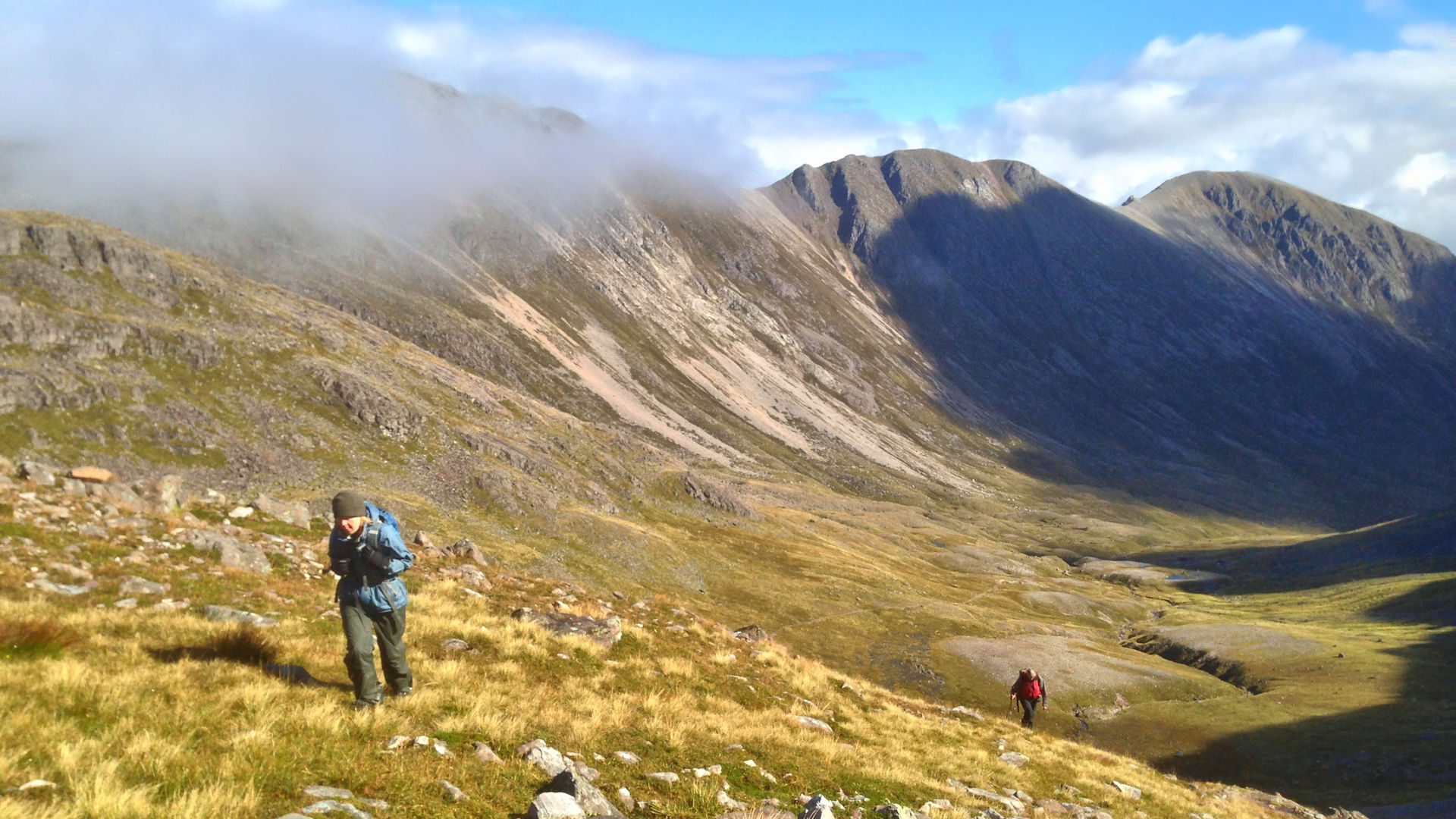
A wild autumn day in Coire Lair
Starting from the car-park at Achnashellach, head to the old red phonebox, then turn left and hike up a track. The track passes some buildings then arrives at Achnashellach rail halt  . Through a gate, cross the railway line, through another gate and into forestry.
Out of forestry, continue up the track for around 50m to a junction, at which point turn left (heading straight on would aim towards the Coulin Pass).
Through gate in deer-fence continue on the track for around 500m or so, then look for a sign and stone marker on your left  - these indicate the start of a path leading down through woodland towards the Allt an Leth-chreig.
Follow the path down to the river, then uphill and out of the woodland. As the path twists uphill, there is a short detour to view a waterfall.
A further 1km on and after climbing around 200m, the path comes to a junction  - stay straight on.
A few metres further on, another junction is reached, marked by a cairn - decision tìme ! Veering left will lead into Coire Lair and an ascent of Beinn Liath Mhòr via its western shoulder, Keeping right leads onto Beinn Liath Mhòr's eastern top followed by a continuation along the ridge.
- stay straight on.
A few metres further on, another junction is reached, marked by a cairn - decision tìme ! Veering left will lead into Coire Lair and an ascent of Beinn Liath Mhòr via its western shoulder, Keeping right leads onto Beinn Liath Mhòr's eastern top followed by a continuation along the ridge.
The Coire Lair route - follow the path into Coire Lair for around 3km to where the path begins to turn slightly towards away from north-west. Strike up pathless and heathery ground aiming north-west and steepening slopes. Ground is loose but never challenging and Beinn Liath Mhòr's bouldery crest is reached south-west of the summit, from where you should be able to pick up a worn path leading to the top  .
.
The ridge route - follow the path beyond the right fork by the cairn and come to yet one more junction  - at which keep left. After crossing some moorland, the path begins to climb and make a way through scree. Slopes steepen, then ease as grass and more scree is passed. The quartzite scree covered base of Beinn Liath Mhòr's eastern top is reached and a path can be traced through the boulders and onto the summit cairn of this minor top
  . A path continues along the crest, passing a centre peak
  and arrives at the large cairn on Beinn Liath Mhòr .

On Beinn Liath Mhòr's ridge, looking west from just east of the summit
On Beinn Liath Mhòr's ridge, looking west from just east of the summit
3. Sgòrr Ruadh

Descending Beinn Liath Mhor
Beinn Liath Mhòr's summit is made of shattered quartzite boulders, therefore care is needed when descending in wet conditions, as the rock can be very slippy !
Aim west from Beinn Liath Mhòr's summit following a path. As the path zig-zags, lose around 50m of height, then begin to turn south-west. Ignore what looks like a white path heading due south (this leads to the top of a steep scree-run heading into Coire Lair).
The path drops to a rather flat area of sandstone and grass. Progress over this, then start to look for some cairns  which mark an otherwise indistinct route southwards. The cairns lead to the top of a drop where below is a small lochan. The path, now more obvious again, descends down steep, very loose and badly erroded ground where careful footwork is needed !
Upon reaching the lochan  , head around its eastern side and contour around the rise ahead using a worn path. The path becomes vaguer as it drops down to just below the bealach at the head of Coire Lair with its lochan
  .
.
Cross Coire Lair and its path, then strike directly up the steep pathless and grassy slopes ahead. Grass gives way to boulderfield as Sgòrr Ruadh's north-western shoulder  is reached and a path forms. Follow the path uphill as it travels south-east along Sgòrr Ruadh's crest through boulderfield.
A grassy section is crossed higher up, then the base of the final ascent of the day is reached. The path turns onto the northern side of the crest for a bit of easy rock-scrambling fun. If wet, the rock here is a bit slimey and the drops into Coire Lair below are significant, so perhaps keeping true to the crest would be wiser !

Final pull up Sgòrr Ruadh
 is reached, where an untidy cairn rests on a grassy hilltop. Stunning views !
Final pull up Sgòrr Ruadh
4. Fuar Tholl

Mainreachan Buttress and Fuar Tholl
From Sgòrr Ruadh, it's probably easiest to initially head eastwards and aim in this direction for around 300m losing a little height on a gentle slope. A vague path forms and turns south-east just south of a small lochan. Follow this path down to Bealach Mhòr encountering Loch a' Bhealaich Mhòir  and a few other minor little lochans.
Cross the bealach, and pick up a stalker's path  and follow it to its highest point.
Leave the path and continue southwards, passing more lochans and gain the scree at the foot of Creag Mainnrichean. A path can be seen heading up the scree, follow this as it then turns around the south side of the crags ahead. The ground steepens and a bit of clambering is required to progress. The flat top of the ground above Creag Mainnrichean  is gained with fine views of the Mainreachan Buttress and Fuar Tholl ahead.
Aiming south-east to begin with, follow the grassy crest above Coire Mainnrichean. Ascend a short section of bouldery ground then cross the grass-covered ground just south of the highest point on the top of Mainreachan Buttress  to lose a little height and reach the bealach below Fuar Tholl, where a small cairn stands.

Fuar Tholl's summit and view north over Coulin to Torridon
 , where a circular dyke near encloses the faint remains of a base of a trig point.
Fuar Tholl's summit and view north over Coulin to Torridon
5. Return to Achnashellach

Returning along Fuar Tholl, path can be seen dropping into Coire Mainnrichean
From Fuar Tholl's summit, return down the path over the grass-covered slope to the cairn on the bealach.
From the cairn there is a path which heads straight down into Coire Mainnrichean - it's steep and twisty as it descends loose scree to drop to the damp grassy ground in the coire below where it meets up with the stalkers path close to where it crosses the Allt Coire Mainnrichean.
In winter a cornice forms above Coire Mainnrichean and the path down the coire will therefore not be accessible.
If you don't fancy the steep scree descent into Coire Mainnrichean, or conditions prevent its use, re-trace your steps back along the crest above the coire and around Creag Mainnrichean to return to the highest point on the stalkers path above Bealach Mhòr.
Turn east and follow this path as it crosses the Allt Coire Mainnrichean then heads down into Coire Lair. The path eventually drops to the River Lair  , which in most conditions should be fairly straightforward to cross.
Once on the north bank of the River Lair, a short climb up the path picks up the main path by the cairn , which is then followed for a return to Achnashellach.
Another alternative direct descent can be made from Fuar Tholl south-east over Sgùrr a'Mhuilinn to the railway line below. However there no paths in this direction and careful route selection will be required to avoid the many sections of slabby rock.
6. Extended route to Maol Chean-dearg

Heading along Sgòrr Ruadh's north-west ridge
From Sgòrr Ruadh, the route can be extended over to Maol Chean-dearg. There are two main options.
One option is from Sgòrr Ruadh's summit to return along the crest of its north-western shoulder to where it was ascended , then continue north-westwards to the rise of Stùc a' Choire Ghrannda then drop to the path above Bealach Bàn. The path is then followed to Bealach na Lice and Maol Chean-dearg is ascended by its east ridge. Although this route appears to minimise height loss, the scree on Stùc a' Choire Ghrannnda is a pain and the deep heather between Bealach na Lice and Maol Chean-dearg's slopes is tiresome, particulary on ascent.
A better option is from Sgòrr Ruadh's summit to retrace steps back along the crest down 50m to where the bouldery, rocky ground gives way to grass. Turn south-west and aim directly down the steep fall-line on scree and through heather - tough going for just over 1km.
Reach Loch Coire Fionnaraich and cross the burn at the loch's outflow, then continue south-west uphill, over wet slippy grassy ground for 1km and pick up the path heading to Bealach a' Choire Ghairbh.

Descending directly down to the Fionn Abhainn
Descending directly down to the Fionn Abhainn
Route profile »

Maps and GPX downloads »


|
Download GPX of route |

|
Open route in OS Maps |
The map images above link to items on Amazon. A small commission is earned on any map purchased which helps fund the operating costs of this website.
Weather forecasts »
| Regional | MWIS - Northwest Highlands |
| Peak specific | Mountain Forecast.com Met Office YR.no |
| Seasonal | SAIS - Torridon Midge forecast |
Alternative and nearby routes »
Coulin Forest from Glen Torridon | |

|
Hillwalking route from Glen Torridon up Munros and Corbetts in Coulin Forest. Beinn Liath Mhòr, Sgòrr Ruadh, Sgùrr Dubh and Sgòrr nan Lochan Uaine. Peaks : 2 Munros, 2 Corbetts
Ascent : 1750m (5740ft) Distance : 21km (13m) Time : 8:10hr |
Maol Chean-dearg and An Ruadh-Stac | |

|
Hillwalking route up Maol Chean-dearg and An Ruadh-Stac from Coulags. A fine outing on old stalkers’ paths, with some easy scrambling on An Ruadh-Stac. Peaks : 1 Munro, 1 Corbett
Ascent : 1400m (4590ft) Distance : 19km (12m) Time : 7:5hr |
Beinn Damh from Torridon | |

|
A lovely hillwalking route climbing from Loch Torridon through Scot's Pine woodlands and onto the crest of Beinn Damh above dramatic coires. Peaks : 1 Corbett
Ascent : 960m (3150ft) Distance : 12km (7m) Time : 4:50hr |
Beinn na h-Eaglaise from Loch Torridon | |

|
Hillwalking route up Beinn na h-Eaglaise from Annat. Quiet hill with Torridon views, pine forest, grassy slopes, twin tops and hidden lochans. Peaks : 1 Fiona
Ascent : 750m (2460ft) Distance : 11km (7m) Time : 4hr |
Applecross Corbetts | |

|
Hillwalking route up Sgùrr a' Chaorachain and Beinn Bhàn in Applecross, with wide grassy crests above dramatic corries, cliffs and buttresses. Peaks : 2 Corbetts
Ascent : 1350m (4430ft) Distance : 14km (9m) Time : 5:45hr |


