

Bridge of Orchy Munros
Routes up Beinn Dorain, Beinn Achaladair & neighbours
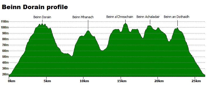
The slopes of Beinn Dorain sweep directly up from the West Highland Way to form a conical mountain, unmistakable when driving up from the south. It has two large cairns on its summit to confuse walkers in mist ! Beinn Mhanach is a quiet hill, hidden for the most part from the roadside. The impressive mountains of Beinn a'Chreachain and Beinn Achaladair form the northern ramparts of this circuit upon which high-level wide ridge walking can be savoured. Beinn an Dothaidh presents the finest views northwards towards the Mamores and Ben Nevis.Main route summary

Map base ©OpenStreetMap
Be prepared for a real peat-boggy start to your outing particularly after rain and, if heading out in winter snow and ice, the eastern approach up Beinn Achaladair may require axe and crampons. Finish the day off with a pint back in the Bridge of Orchy Hotel.
| Munros |
Beinn Dorain (1076m, Munro 64) Beinn Mhanach (953m, Munro 210) Beinn a'Chreachain (1081m, Munro 61) Beinn Achaladair (1038m, Munro 94) Beinn an Dothaidh (1004m, Munro 129) |
| Ascent | 2560m (8,400ft) |
| Distance | 28km (17.5m) |
| Time |
walking : 11:15hr* running : 5:45hr *Naismith's rule : 4km/h distance + 600m/h ascent |
| Start/finish |
Bridge of Orchy
(grid ref : NN300394) |
| Profile | ||||
| Maps |
The map images above link to items on Amazon.
A small commission is earned on any map purchased which helps fund the operating costs of this website. More information on maps is on this page
|
|||
| Downloads | ||||
| Terrain |
| |||
| Navigation |
| |||
| Effort |
| |||
| Scenery |
| |||
| Meanings | Beinn Dorain : 'hill of the streamlet' Beinn Mhanach : 'monks' hill' Beinn a'Chreachain : 'scallop-shaped hill' Beinn Achaladair : 'hill of the field by the hard water' Beinn an Dothaidh : 'hill scorching' |


Route detail & map »
Getting to Bridge of Orchy »
- As a group of 5 Munros, these hills are best accessed from Bridge of Orchy, 10km north of Tyndrum on the A82. Although parking by hillgoers at Bridge of Orchy Station is discouraged, there is room for several cars. Other parking is available in a large car-park by Bridge of Orchy Hotel.
Beinn Dorain »
-
From the railway station car-park, cross the train-line via the underpass.
Through a gate, cross the West Highland Way
 and head up a path around the left of the phone mast.
Usually mucky and wet, the path can be icy in winter making for slippy progress.
and head up a path around the left of the phone mast.
Usually mucky and wet, the path can be icy in winter making for slippy progress.
- The path, rough all the way and downright boggy in bits, continues up to Coire an Dothaidh and to the bealach at 744m
 .
.
- At the bealach cairn, turn south-west-south and follow a path uphill.
- After around 300m of ascent and 1.5km, a large well built cairn
 is met - this is often referred to as the 'Sassenach's Cairn' - in mist you might take this to be Beinn Dorain's summit - it's not !
- Continue south for a few more minutes, down and up a narrow dip and Beinn Dorain's main summit
 is reached.
Stunning views in all directions and it's amazing how near the A82 appears below.
is reached.
Stunning views in all directions and it's amazing how near the A82 appears below.
Beinn Mhanach »
-
Return to 'Sassenach's Cairn' on Beinn Dorain's north top, then turn east following a wide ridge heading towards Meall Garbh.
- After losing around 300m of height you'll come to a more level area
 , start heading more northwards and down grassy wet ground to pick up a burn that flows to the Allt Coire a'Ghabhalach
  at around c500m.
- The burn should be straightforward to cross (unless in spate), after which contour below Coire a'Ghabalaich over more grassy wet ground to meet the track
 below Beinn a'Chuirn
  .
.
- From here, the direct route up Beinn a'Chuirn is a tad loose and steep, so instead follow the track northwards, over a burn and walk around the north side of Beinn a'Chuirn to the bealach
 between Beinn a'Chuirn and Beinn Mhanach. You'll meet up with a line of fence-posts on the way.
- From this bealach aim directly east over easy ground and on a faint path to Beinn Mhanach's summit
 .
.
Beinn a'Chreachain »
-
Return to the bealach between Beinn Mhanach and Beinn a'Chuirn, then following fence-posts, aim north-west downhill over grassy ground to pick up a burn to follow to the Allt Cailliche.
- Cross this river (should be straightforward unless in spate) and one or two other minor burns, then aim uphill for Garbh Mheall, the south arm of Meall Buidhe.
- Approaching Meall Buidhe
 , pick up and follow a path heading north-east to the bealach
  below Beinn a'Chreachain.
- Continue up bouldery ground to Beinn a'Chreachain's summit ridge, then turn south and follow the rim of Coire DubhBeag to reach the cairn on Beinn a'Chreachain's summit
 to take in superb views over Rannoch Moor and beyond.
Beinn Achaladair »
-
Return to Meall Buidhe , then continue following the path south-west over easy ground to the mucky bealach
 below Beinn Achaladair.
- Cross the bealach and a dilapidated fence-line.
- Normally an easy walk up from the bealach, the steep path ahead can be quite a challenge in icy conditions, especially if snow covered.
- Once levelled-out ground is reached the going is straight-forward to Beinn Achaladair's cairns
 - there are 3 summits with the middle second being the top.
Beinn an Dothaidh »
-
Continue following the path heading south-west, then south, ascending a further top
 (marked 1002m) with a small cairn on its crest.
- After a further 1km heading south and downhill, the path starts to turn south-west and head towards the bealach
 above Coire Daingean.
- The path crosses the bealach and aims uphill on grassy ground to the south top
 of Beinn an Dothaidh.
- Beinn an Dothaidh's main summit
 is a few minutes further on, down and up a dip, following the path.
Return to Bridge of Orchy »
- On a fine day, from Beinn an Dothaidh's summit cairn head west to its western top and take in some final views for the day.
- Alternatively for a more direct descent, from Beinn an Dothaidh's summit cairn aim south-west downhill on grass-covered slopes.
A path gradually evolves as ground becomes steeper
 and leads to the bealach between Beinn an Dothaidh and Beinn Dorain, from where retrace your steps back to Bridge of Orchy.


 as described in the reverse of the 'Main route'.
 and pick up a track back to Achallader Farm and the car-park.
 .
.
 .
.
 .
There is one further top on Beinn an Dothaidh, the westerly peak
.
There is one further top on Beinn an Dothaidh, the westerly peak 


