
Munros above Geldie Lodge
Route up Càrn an Fhidhleir and An Sgarsoch above Geldie Lodge. Remote Munros west of Linn of Dee, between Glen Tilt and the Geldie Burn.
Route outline
| Munros | ||||
| Walk ascent | 830m (2720ft) | |||
| distance | 13km (8m) | |||
| time | 4:40hr | |||
| Bike ascent | 140m (450ft) | |||
| distance | 25km (16m) | |||
| time | 2:45hr | |||
| Start/finish | Linn of Dee, Braemar Grid Ref : NO064898 | |||
| Terrain |
| |||
| Nav |
| |||
| Effort |
| |||
| Scenery |
| |||


This route heads in from Linn-of-Dee near Braemar, from where a fine cyclable track leads to Geldie Burn and Geldie Lodge. Apart from a track below An Sgarsoch in the glen heading westwards from Geldie Lodge and a faint path on Càrn an Fhidhleir's crest, the route is pathless for the most part.
Show map

Route description
1. Getting to Linn of Dee

Near White Bridge on the track to Geldie Lodge
From Braemar, drive west along its main street, veering right at Braemar Brewery and Hazelnut Patisserie, then continue on an unclassified road for 9km to the bridge over the Linn of Dee. Cross the bridge, turn sharp right and you'll come to a large car-park on your left. There is a one-way system around this car-park which is operated by the National Trust for Scotland and there is a daily charge of £3 to park.
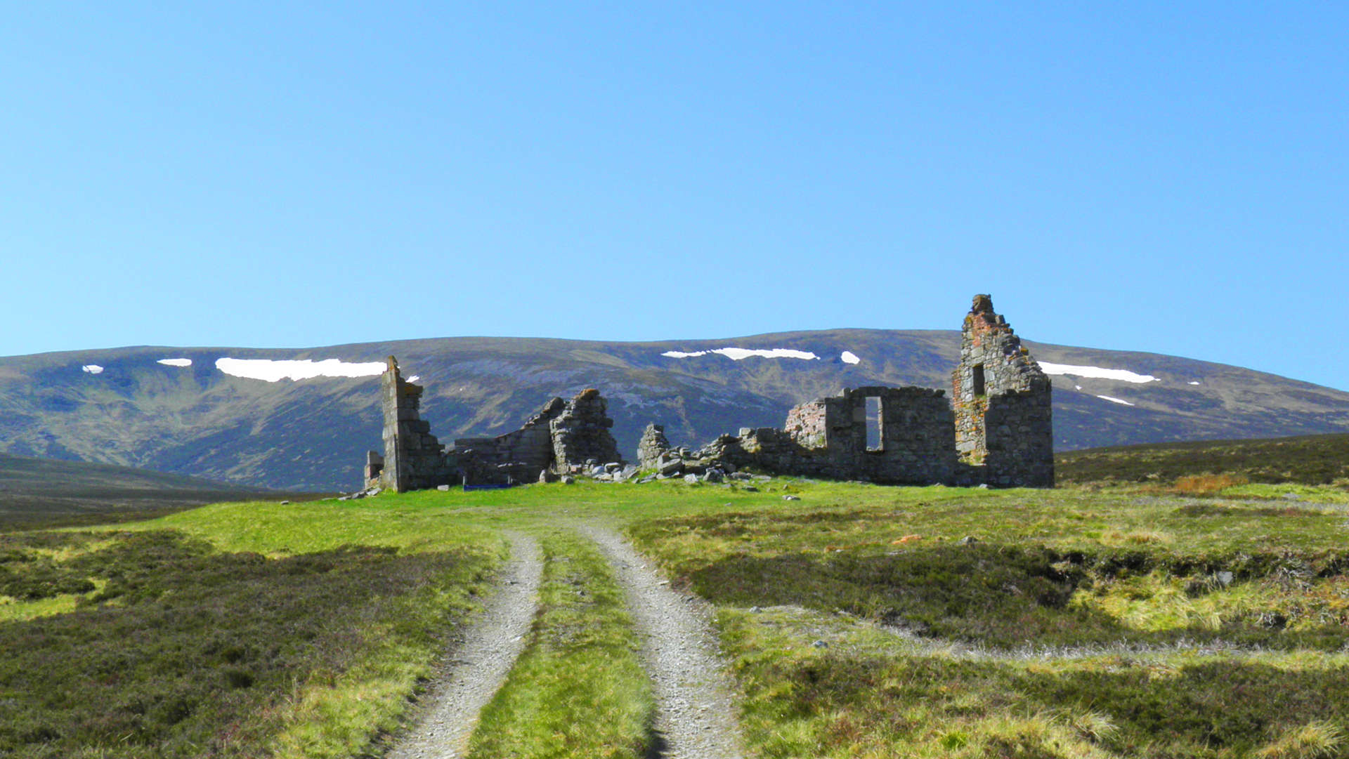
2. Approach to Geldie Lodge ruins

By Red Hut in Geldie Burn
On bike, leave the car-park onto the road, turn right and head back towards the bridge at Linn of Dee. Just before the bridge a barrier blocks a track heading off west. Cycle along this track for 4.5km to White Bridge  .
.
Cross the bridge and keep on the main track heading south-west. After another 2km, the track turns west, passes Red Hut  , then becomes quite rough as it continues to a knackered wooden bridge (sign saying dangerous to cross).
Beyond the bridge the track becomes easier, but further on the Allt Dhaidh Mòr  needs crossing, which can be tricky in spate. The track then drops down to Geldie Burn
  , probably the best place to leave bikes (as the track west of Geldie Lodge is now a path with the NTS removing the track in the early 2000's - most maps have been updated to reflect this).
Crossing Geldie Burn is a doddle in summer, but in spate, it will demand that you take your footwear off ! On the south side of Geldie Burn, the sad ruin of Geldie Lodge  is 400m up a track.
3. Càrn an Fhidhleir (Càrn Ealar)

Hiking from Geldie Lodge towards Càrn an Fhidhleir
From behind Geldie Lodge, follow a fine path westwards to its end  , some 3km away. The path ends abruptly, from where a rough boot-worn paths cuts a route through heather and over soggy ground to drop to the Allt a'Chaorainn
  .
.
Cross this burn, then pick up and follow a faint path through the heather for around 1km. As the gradient starts to steepen, the path disappears, but sections of grass surrounding one of the burns make a clear way uphill. Eventually the grass gives way to boulders - a sign that Càrn an Dhidhleir's crest is nearly reached.
Once up onto the crest  , turn south and attain Càrn an Fhidhleir's summit with its small cairn.
4. An Sgarsoch

Hiking up An Sgarsoch with Càrn Ealar behind
If the mist is down on Càrn an Fhidhleir, navigational skills will be needed to continue to An Sgarsoch.
From the cairn on Càrn an Fhidhleir, aim south-east following a faint path and drop to a bealach  before the rise up to the top marked on the OS map with a spot height of 906m. Don't head up this, instead look for a faint path heading east-south-east. This path becomes more obvious and gradually turns to drop on wet grass and tussocky ground to the peaty bealach
  below An Sgarsoch.
Cross the bealach and pick up a faint path through the heather climbing up the An Sgarsoch's western shoulder. The heather gives way to grass and stones higher up and eventually the large cairn on An Sgarsoch's summit  is reached.
This is a fine summit for views on clear days. On windy days, the cairn provides plenty shelter for a few hardy folk.
is reached.
This is a fine summit for views on clear days. On windy days, the cairn provides plenty shelter for a few hardy folk.
5. Return

Returning to Geldie Lodge, view to Beinn Bhrotain
Leave An Sgarnoch's summit and follow a barely distinguisable path for 1km east. Turn north and start losing height following the crest of An Sgarsoch's north-east shoulder.
At around 800m contour, the ground steepens somewhat and thick heather will need bounded over.
Further down the ground levels out and becomes easier to progress following the grass covered banks of the Allt Coire an t-Seilich  . Count how many times you cross this burn ! A path evolves on the west side of the burn and Geldie Lodge is approached. Cross Geldie Burn, pick up your bike and return back to Linn-of-Dee.
Route profile »

Maps and GPX downloads »


|
Download GPX of route |

|
Open route in OS Maps |
The map images above link to items on Amazon. A small commission is earned on any map purchased which helps fund the operating costs of this website.
Weather forecasts »
| Regional | MWIS - Southeast Highlands |
| Peak specific | Mountain Forecast.com Met Office YR.no |
| Seasonal | SAIS - Southern Cairngorms Midge forecast |
Alternative and nearby routes »
Càrn a' Chlamain via Glen Tilt | |

|
Hiking and biking route up Càrn a’ Chlamain from Blair Atholl via Glen Tilt. An estate track follows the River Tilt before a climb to the bouldery summit. Peaks : 1 Munro
Ascent : 1090m (3580ft) Distance : 26km (16m) Time : 5hr |
Sgòr Mòr from Linn of Dee | |

|
A hike from Linn of Dee up heather-clad slopes aside fence posts to the summit of isolated Sgòr Mor, from where superb views are had of the Cairngorms. Peaks : 1 Corbett
Ascent : 650m (2130ft) Distance : 18km (11m) Time : 5:30hr |
Cairngorm darkside from Linn of Dee | |

|
Route up Ben Macdui and neighbouring Munros from Linn of Dee. Vast plateaux, granite tors, forests and the chance to spot reindeer herds. Peaks : 4 Munros
Ascent : 1850m (6070ft) Distance : 35km (22m) Time : 10:15hr |
Beinn Dearg from Calvine | |

|
Hillwalking and biking route through Glen Bruar to Beinn Dearg, this Munro is reached on estate tracks and paths, the direct line starting at Calvine. Peaks : 1 Munro
Ascent : 1170m (3840ft) Distance : 31km (19m) Time : 5:30hr |
Leathad an Taobhain from Glen Feshie | |

|
Bike through beautiful Glen Feshie on estate tracks, then a steep push gets close to Leathad an Taobhain, leaving a short hike to the summit. Peaks : 1 Corbett
Ascent : 900m (2950ft) Distance : 33km (21m) Time : 4:20hr |


