Glen Rosa Horseshoe
Hillwalking route up Goatfell and other Corbetts above Glen Rosa on Arran
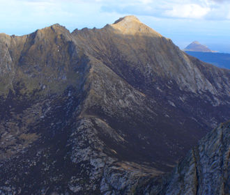
On the Isle of Arran, a superb hillwalking day can be had on a stunning circuit of Corbett peaks around Glen Rosa. The route follows crests and ridges, takes in Goatfell and involves some moderate rock-scrambling on granite.
Route outline
| Corbetts | ||||
| Ascent | 2200m (7210ft) | |||
| Distance | 21km (13m) | |||
| Time | 9:00hr | |||
| Start/finish | Glen Rosa campsite Grid Ref : NS001377 | |||
| Terrain |
| |||
| Nav |
| |||
| Effort |
| |||
| Scenery |
| |||
The Isle of Arran is a popular tourist destination, with Glen Rosa quietly travelling north-west away from the bustling main town of Brodick. Overlooking Glen Rosa is a circuit of ridges with rugged, craggy and intriguing peaks. The Glen Rosa Horseshoe route follows these ridges, takes in the island's highest peak Goatfell and gives some stunning views.
A well maintained network of paths in the glens leads to defined routes up hillsides and through corries onto higher ground where crests are easily navigated along. On route, some tricky and exposed scrambling can be enjoyed or easily by-passed if desired.
Show map
Route description
1. Getting to Glen Rosa

The approach up Glen Rosa
There are two ferries that serve the Isle of Arran, both run by Calmac, one from Claonaig in Kintyre to Lochranza, at the north end of the island, the other bigger ferry from Ardrossan to Brodick, the main town on the island. Calmac's website is here.
From Brodick, follow the main street northwards to where the road takes a sharp turn east, aside a junction with the B880 marked to the left towards Blackwaterfoot. Turn on the B880 and follow it for 100m to where a side-road, with a walker's sign pointing to Glen Rosa, heads off to the right.
Travel up this narrow road for just over 1km, through a gate and to a parking area by Glen Rosa campsite entrance. It used to be possible to drive further and along a rutted track for another 500m and park by a walkers sign (for Brodick) and gate, but I suspect this is no longer the case.
2. Beinn Tarsuinn

Looking up Glen Rosa to Beinn a' Chliabhain, the south-eastern minor summit of Beinn Tarsuinn
On foot, leave the car-park behind and follow a track westwards for 2km as it makes its way between some forestry and Glenrosa Water to open grassland and a footbridge  over the Garbh Allt. Don't be tempted by a faint path that heads uphill around 200m before reaching the bridge - it crosses rough terrain and heads through thick grass to follow an old pipe to a dilapidated old weir.
Once over the bridge, the track ends with two paths taking over - turn sharp left and strike uphill on a coarse but obvious path. The path narrows and becomes rougher, but can be readily traced following the northern bank of the Allt Garbh upstream.
Higher up, the path crosses the burn  , heads through a protected plantation to reach the foot of Beinn Nuis. Ahead the ground steepens abruptly, with the path becoming more distinct as it climbs up the south-eastern shoulder of Beinn Nuis and onto its summit
  . The views from here all around are quite thrilling.

The Old Man of Tarsuinn
 is reached from where some stunning views can be appreciated.
The Old Man of Tarsuinn
3. A' Chir and Caisteal Abhail

A' Chir and Caisteal Abhail from Beinn Tarsuinn
Looking northwards, the slabs and rocky outcrops on A' Chir look intimidating - there doesn't appear to be a straightforward way up this ridge.
If you're a climber or competent rock-scrambler, you'll enjoy traversing the undulating granite crest. For hill-runners and hikers looking for an easier alternative, there is one to be found on the western side of the hill.
From Beinn Tarsuinn, pick your way down the path to Bhealach an Fhir Bhoghla. The path the splits - take the branch on the left. The path begins to bypass A' Chir, but after travelling around 500m on from the bealach, a small grassy area is reached before the path heads under rocks and slabs. Strike directly uphill on heather with occasional faint traces of path towards A' Chir's summit  . Some boulders on the top will need negotiating, but there's nothing too difficult or exposed.
From A' Chir, begin to return the same way as up. If you like scree, some fun can be had descending a channel. The path below is picked up and followed northwards without difficulty towards the bealach  before Cir Mor.
Cross the bealach and when a cairn is reached, take the path heading northwards by-passing Cir Mhor. This path travels over grass, through heather and across boulderfield to gain the next bealach  , with Caisteal Abhail dominating the view ahead.
Having crossed boulderfield, the rise ahead on the curving crest ahead climbs gently, mainly on grass, up to Caisteal Abhail's wide summit.

Caisteal Abhail from the western slopes of Cir Mhor
 is on top the large granite tor on the summit and looks daunting from this approach, however a path heads around to the northern side of the tor from where the rock is easily conquered.
Caisteal Abhail from the western slopes of Cir Mhor
4. Cir Mhor

Cir Mhor and Goatfell from Caisteal Abhail
About-turn and retrace your steps back to the bealach  between Caisteal Abhail and Cir Mhor. Sticking to the well-worn path on the ridge ahead, climb directly. The path merges with the other travelling up from A' Chir from where a short distance remains to the cairn on Cir Mhor's summit
  .
.
On the rise to Cir Mhor, although straightforward to hike up, with height gained, cliffs begin to fall away to the north. The summit is an airy place !
5. Goatfell

Looking along The Saddle to North Goatfell and Goatfell
Getting off Cir Mhor down to The Saddle along the east ridge can be challenging and only really for climbers or competent rock-scramblers. The initial exposed scrambling higher up is followed by a defined path leading to 'The Saddle'  .
.
Alternatively, a longer but easier route can be made by returning to the bealach  between Cir Mhor and A' Chir, where a path drops towards Glen Rosa. Descending this path for a bit leads to below Cir Mhor's crags, where a faint path heading east through heather can be picked up and followed as it contours around Cir Mhor to meet with another well-used path coming down from The Saddle
  .
.
Follow the path up to The Saddle, then turn eastwards and trace the line of a winding path climbing over grass, loose scree and around boulders up North Goatfell's north-western shoulder onto its summit  .
.
The path continues south along Stacach, the crest between North Goatfell and Goatfell. There are a couple of large rocky tors on the ridge, which can be fun to scramble over in dry conditions. The path turns around these tors under their east facing sides then climbs up one last time onto Goatfell's summit  .
.
Goatfell's summit is broad and grass-covered, scattered with granite rocks and boulders with a trig point and viewfinder standing on the highest point. The views from Goatfell's summit are vast and superb.
6. Return via 'Goatfell Tourist Route'
Having traversed the ridges so far on the Glen Rosa Horseshoe, possibly meeting only a handful of other hillwalkers, the likely hustle and bustle on Goatfell may come as a surprise. Most of the people on Goatfell's summit will have hiked up the 'tourist route' and this is the most obvious choice for a descent back towards Brodick.
A descent down Goatfell's 'tourist route' begins steeply at first, twisting and turning between rocks as it heads eastwards towards Meall Breac. As the slope becomes more gentle, the path splits with the 'tourist route' turning southwards to head towards Brodick Castle and Cladach. Lower down roads can followed for a relaxed return to Glen Rosa campsite, or a more direct can be made following some ATV tracks around some forestry followed by a wade across Glenrosa Water.
Continuous erosion to Goatfell's 'tourist route' caused by boot-traffic and weather, means regular maintenance is required and this is carried out by the NTS. More information is on their website here.
7. Glen Rosa Hill Race
The Glen Rosa Horseshoe Hill Race used to take place in June and was last run in 2012. This was a tough race which I ran a couple of times, and managed a second place in 2007 (though I have to own up that there were only 25 runners who completed the race that year).
The race differs from the route above in various places. The race route starts from Brodick Castle and follows a track then faint path along the northern bank of Glenrosa Water to the foot of Beinn a'Chliabhain. After climbing Beinn a'Chliabhain, runners were directed downwards over heather into Coire Daingean, around and below the crags of A' Chir, followed by a climb up Fionn Choire to the bealach between A' Chir and Cir Mhor. After touching the summit of Cir Mhor, runners returned to the bealach and took the by-pass path to The Saddle to then follow the route above over Goatfell and back to Brodick Castle.
Route profile »

Maps and GPX downloads »

|
Download GPX of route |
The map images above link to items on Amazon. A small commission is earned on any map purchased which helps fund the operating costs of this website.
Weather forecasts »
| Regional | MWIS - Western Highlands |
| Peak specific | Mountain Forecast.com Met Office YR.no |
| Seasonal | Midge forecast |


