

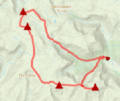
Glenshee 9 Munros
Long high-level route linking the 9 Munros above Glenshee. With grassy slopes, this is one of the easier multi-Munro circuits, and a hill race.
Route outline
| Munros | ||||
| Ascent | 1690m (5540ft) | |||
| Distance | 30km (19m) | |||
| Time | 10:15hr | |||
| Start/finish | Glenshee Ski Centre Grid Ref : NO141774 | |||
| Terrain |
| |||
| Nav |
| |||
| Effort |
| |||
| Scenery |
| |||


The route described here is also the line used for the Glenshee 9 Munros Hillrace and for the most part, follows good tracks and paths. The areas around Tolmount and Tom Buidhe however are fairly featureless and pathless and require careful navigation in mist.
With just 1,690m of ascent over a distance of 30km, the climbs are generally gentle. Most of the terrain underfoot is grass-covered, though there is a fair amount of boulderfield to contend with on the summits of Creag Leacach, Cairn of Claise, Càrn an Tuirc and Càrn Aosda.
In winter, mountain-hares on Creag Leacach abound, darting with ease over the crisp snow. Winter also hides the ugly scars that have been created by the many ski-tows.
Show map

Route description
1. Getting to Glenshee

The Glenshee Ski Centre
The A93 connects Perth with Aberdeen, passing through Braemar in Deeside. A few miles south of Braemar, Glenshee Ski Centre is just below the col on the road's highest point. Unless skiing is in full swing, there are usually no problems parking by the ski centre or in the vast rough area east of the road. Park at highest point on the A93, just south of Glenshee ski centre and by the snow-gate and large mast.
2. Creag Leacach

Following the wall to Creag Leacach
There is a track that starts by the mast. Aim north-east uphill on this track for around ½km to meet up with some buildings and ski-tows  . Beyond the buildings turn south east, still following the track.
Continue up to Meall Odhar
. Beyond the buildings turn south east, still following the track.
Continue up to Meall Odhar  and the top of ski-tow. The track ends and there is a small cairn marking this minor summit.
Now on a wide, rough and worn path, slightly further on you'll pick up a fainter path on right  , just before the pull directly up Glas Maol begins.
Turn onto this path as it turns south and contours around the base of Glas Maol.
, just before the pull directly up Glas Maol begins.
Turn onto this path as it turns south and contours around the base of Glas Maol.
The path reaches the crest of Glas Maol's southern shoulder and a cairn  .
Beyond the cairn, pick up a line of fence-posts and remains of a wall crossing a wide expanse of grass-covered ground. Following the posts southwards, watch your footing to avoid tripping over wires.
.
Beyond the cairn, pick up a line of fence-posts and remains of a wall crossing a wide expanse of grass-covered ground. Following the posts southwards, watch your footing to avoid tripping over wires.
The wall makes a sharp turn, at which point you can find a small shelter in the wall on its east side.
There's now quite a change in the terrain on the crest - ground becomes much more stoney and bouldery in sections. Keep following the wall over a couple of minor bumps to end up on Creag Leacach's summit  .
Excellent views southwards from Creag Leacach's summit cairn.
.
Excellent views southwards from Creag Leacach's summit cairn.
3. Glas Maol

Glas Maol from Creag Leacach
From Creag Leacach's summit, about-turn and re-trace your steps following the wall and the fence posts back to the cairn .
Ahead you'll be able to make out a worn path making a route through the grassy ground aiming uphill. Follow this path, meeting occasional posts and climb around half way up the grass-covered hillside ahead.
You could continue following this path and the posts onto Glas Maol's summit crest, but you'll end up at a point around 300m north-west of the summit, from where you can follow a line of posts south-east to Glas Maol's summit - this is probably the safest option in mist or whiteout.
If conditions are clear, instead, from the halfway point up the hillside, take a bearing to Glas Maol's summit and hike directly to it, crossing a small patch of boulders on the way.
Glas Maol's summit has a trig-point surrounded by large cairn  . The views are slightly masked by the bulk of the summit dome !
4. Cairn of Claise

Running over grassy ground to Cairn of Claise
Leaving Glas Maol's summit behind, aim sligthly east of north, descending a gentle incline on grassy and pathless ground. You should meet up with ATV track coming from the south-east  . Stick to this track travelling north, passing the top of the Glas Maol Poma on your left.
Shortly after passing the top of the tows, the track turns sharp right (north-east) and drops to the bealach between Glas Maol and Cairn of Claise. The bealach can be rather soggy, particularly after rain.
The track has running been aside a sporadic line of fence-posts, but shortly after starting to climb, the line of posts leave the track and instead head for the south-west crest of Cairn of Claise. This leads onto boulderfield and meets up with a wall all of which can be hard work, so better to stick with the ATV track instead.
The ATV track traces a route just under the crest keeping boots on grassy terrain. On approaching the summit of Cairn of Claise, leave the track and cross a short section of boulderfield for around 100m or so to gain the summit  . Cairn of Claise's summit has a large, well-constructed symetrical cairn rising from a wall that runs along the crest of the Munro.
5. Tom Buidhe

The undulating ground of Tom Buidhe
From Cairn of Claise's summit there's a bit of a decision to be made ! Navigation over to Tom Buidhe and Tolmount requires a bit of concentration, particularly if mist is down. You might want to opt to visit these two Munros on another day, perhaps approaching from Glen Doll or Glen Callater. If this is the case, Càrn Tuirc would be the next peak (see this page for direct route).
To aim for Tom Buidhe, from Cairn of Claise's cairn, follow the wall eastwards to its end  , then bear due east over grassy ground. A faint path and ATV tracks with occasional iron posts can be picked up and followed over undulating grass-covered ground.
After around 1km, the line of fence-posts turns in the direction of Tolmount - continue following the path eastwards. Up and over the minor bump of Ca Whims, the track becomes a bit more obvious as it climbs up the last kilometre of Tom Buidhe's grassy slope, on the way note the path joining from the left (north-west)  . Only a small pile of stones mark Tom Buidhe's summit
  - not any shelter here !
6. Tolmount

Tolmount's summit
About-turn on Tom Buidhe's summit and retrace your steps to for around ½km, to the split on the path . Take the path heading north-west and follow it downhill towards a burn in the middle of the bowl ahead  .
.
After crossing the burn, the path seems to disappear - aim uphill directly ahead, then turning north-north-east, you should be able to see a line of iron fence-posts  . The line of posts is the continuation of the line left earlier between Cairn of Claise and Tom Buidhe.
The line of posts and a faint path alongside it continue over grassy ground northwards in the direction of Tolmount. As Tolmount's summit nears, ground becomes a bit more rocky in places, with the cairn on the top being a rather untidy bouldery pile  . Amazing how close Lochnagar looks from here !
7. Càrn an Tuirc

Leaving Tolmount and heading to Càrn an Tuirc
From Tolmount's summit, return south-east-south for ½km following the fence-posts and path to close to where you picked them up earliier . Now turn right (westwards), continuing on a faint path down to a hollow with the source of a burn. The path completely disappears and navigation becomes testing from here !
Ascending gentle slopes, head slightly north of west over grassy, and sometimes wet, ground for around 1km. You'll reach Cairn of Claise's northern broad shoulder, from where after a bit more hiking, a descent to the bealach  between Cairn of Claise and Càrn an Tuirc is made.
A path is picked up at the bealach which is followed to a junction further on. Taking the lower fork (left), the path continues over easy ground, rising slightly to a large flat summit area. Terrain from here becomes boulder and scree covered, however a faint path can be picked up making a way through.
The summit cairn of Càrn an Tuirc  comes into view with a circular stone shelter a short distance westwards.
8. Càrn Aosda

Below Càrn an Tuirc with Càrn Aosda ahead
Leaving Càrn an Tuirc's cairn behind, initially head west-north-west to find a path that picks its way through scree, then the heather, downhill. As the ground levels out, the going underfoot becomes sodden until the Allt a'Gharbh-choire  is reached. Crossing this burn will be challenging if in spate !
Beyond the burn-crossing, a good path winds its way following the northern bank of the burn to an old bridge  below the A93. Over the bridge and cross the road, then strike directly uphill through fairly thick heather. Alas there is no path, but heather becomes more stunted with height gained. Higher up the northern arm of Càrn Aosda is gained and ascent easies.
As the ground levels out, the heather disappears and the terrain underfoot becomes easier. Càrn Aosda's bouldery summit  is reached, with its small cairn sitting just above the ironwork of the Càrn Aosda T-Bar !
9. Càrn a' Gheoidh

Càrn a' Ghèoidh from the north-east
From Càrn Aosda's summit, follow a wide track/ski-run south-west around the top of the ski-tows and down the bealach at the top of Coire Butchart  east of Loch Vrotacha.
At the bealach, don't continue on the track south-east, instead look for a faint path on the right aiming due south. This crosses wet ground and climbs a few metres to the col  between The Cairnwell and Càrn nan Sac.
A good path is picked up and followed south-west above Creag a'Choire Dhirich to a couple of lochans  . Turn around the south edge of the second lochan, following a faint path aiming directly towards Càrn a'Ghèoidh. This path continues over delightful grass-covered ground onto the wide crest east of Càrn a'Ghèoidh.
A path travelling from Càrn an Sac is met on the crest and followed up one short steep section on the final approach to Càrn a'Ghèoidh's summit  .
.
10. The Cairnwell

The Cairnwell from the col below Càrn nan Sac
From Càrn a'Ghèoidh retrace your steps back to the lochans and then to the bealach between Càrn nan Sac and The Cairnwell .
At the bealach, directly ahead look for a scarred path that initially climbs uphill. Follow this as it then turns right (south-east) and cuts a route through heather and stones. As ascent levels out, the path meets up with a ski-run and line of snow fencing.
Follow the ski-run past the top of the Cairnwell Chairlift and continue on a rough track uphill to the huts, masts and weather-station on Cairnwell's summit  . Although rather untidy, the Cairnwell's summit is a fine viewpoint in all directions.
11. Return to Glenshee
It's fairly straightforward to descend directly from Cairnwell downhill to the mast by the snow-gate. This is grassy most of the way with some small patches boulderfield to contend with.
Alternatively for a slightly softer descent, retrace your steps from the Cairnwell's summit for around 200m to just beyond the top of the Cairnwell Chairlift, then make a beeline north-east down grassy slopes to Glenshee Ski Centre directly below.
A third more gentle, but longer option would be to follow the ski-run from the Cairnwell down to the top of Coire Butchart then turn east and hike down another track/ski-run back to Glenshee Ski Centre.
Route profile »

Maps and GPX downloads »


|
Download GPX of route |

|
Open route in OS Maps |
Information on maps and GPX files is on this page.
The map images above link to items on Amazon. A small commission is earned on any map purchased which helps fund the operating costs of this website.
Weather forecasts »
| Regional | MWIS - Southeast Highlands |
| Peak specific | Mountain Forecast.com Met Office YR.no |
| Seasonal | SAIS - Southern Cairngorms Midge forecast |
Alternative and nearby routes »
West of Glenshee | |

|
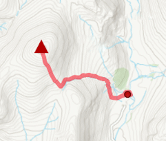
Route over 3 Munros west of Glenshee. Càrn Aosda and The Cairnwell make an easy outing, extended with Càrn a’ Ghèoidh for a longer day. Peaks : 3 Munros, option of 1 Corbett
Ascent : 625m (2050ft) Distance : 11km (7m) Time : 3:50hr |
East of Glenshee | |

|
Hillwalking route over the 4 Munros east of Glenshee, dominated by Glas Maol. High, vast, and pathless, with the option to add Creag nan Gabhar. Peaks : 4 Munros, option of 1 Corbett
Ascent : 910m (2990ft) Distance : 15km (9m) Time : 5:15hr |
Munros above Jock's Road | |
|
Route over Driesh, Mayar, Tom Buidhe and Tolmount above Jock’s Road. A grassy circuit with little feature, sure to test navigation skills. Peaks : 4 Munros
Ascent : 1375m (4510ft) Distance : 26km (16m) Time : 9hr |
Monamenach from Glen Isla | |
|
Hillwalking route up Monamenach from Auchavan in Glen Isla. Estate tracks make this Corbett one of the easiest to bag, with only 450m ascent and simple nav. Peaks : 1 Corbett
Ascent : 450m (1480ft) Distance : 5km (3m) Time : 2hr |
Morrone from Braemar | |

|
A short hillwalk from Braemar up a fine, if rather rough path to the top of Morrone - a superb viewpoint to survey the southern Cairngorms. Peaks : 1 Corbett
Ascent : 480m (1570ft) Distance : 6km (4m) Time : 2:25hr |


