

Monadhliath Munros
Linear hillwalking route over all four Monadh Liath Munros: A’ Chailleach, Càrn Sgulain, Càrn Dearg and Geal Chàrn, with demanding navigation.
Route outline
| Munros | ||||
| Ascent | 1420m (4650ft) | |||
| Distance | 30km (19m) | |||
| Time | 9:50hr | |||
| Start | Glen Road, Newtonmore Grid Ref : NN694998 | |||
| Finish | Garva Bridge Grid Ref : NN521948 | |||
| Terrain |
| |||
| Nav |
| |||
| Effort |
| |||
| Scenery |
| |||


The route starts from just above Newtonmore, where Glen Banchor leads to the foothills of the Monadh Liath. Ruins of deserted townships are dotted around this beautiful glen.
Tracks lower down access the grass and heather clad slopes. Higher up the vast plateaux are places to get easily lost in, but lines of fence-posts with faint paths can be traced. From Càrn Dearg to Geal Chàrn there are no posts to follow and good navigation skills will be needed. As the route starts at Newtonmore and finishes at Garva Bridge - some 24km apart, arranging transport is advisable.
The Monadh Liath feels wild and remote and there's a good chance you might see wildlife, possibly a golden eagle if you're lucky !
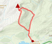
Show map

Route description
1. Getting to Glen Banchor

An Leithir Hut
The route start just a few miles outside Newtonmore at the end of the public road heading into Glen Banchor. To get there, from half way along Newtonmore's main street, by the Letterbox Restaurant, there is the entrance to Glen Road. This narrow road twists uphill past several houses into open moorland. Continuing for another mile or so to the road end, which terminates at a bridge just after a rough car-park which has room for around 10 cars.
This linear route finishes at Garva Bridge, which is around 24 km west of Newtonmore, therefore you'll need to organise some kind of transport between start and end points !
2. A' Chailleach

Approaching A'Chailleach
Immediately before this car-park, there is a track heading up the side of foresty. Follow this track, through gate for just over 1km.
At a sharp turning in the track, there is a path off left (this may be indicated by a small cairn, tho it wasn't on our last visit).The path leads down to a bridge  crossing the burn hidden in the heather below.
Over the bridge, follow a faint path over wet and grassy ground heading northwards and travelling parallel to the burn.The path begins to turn, then head uphill to cross a minor burn.
Further on and in a hollow, An Leitir hut  is met - carvings on wood inside are over 100 years old!
Follow a faint path uphill from behind the hut, getting more obvious as it ascends.
The path levels off in heather and peat before a last direct haul to the summit of A' Chailleach  . A large cairn on the top provides shelter out of wind!
3. Càrn Sgulain

Summit of Càrn Sgulain
From A' Chailleach's summit, aim due north, on a faint path at first. The path disappears as the ground drops progressively more steeply down to a burn (the Allt Cuil na Caillich).
Cross this burn and continue north over rough, wet and peaty ground until a line of fence-posts  is reached.
Turn right (east) and follow fence-posts for less than half a kilometre to Càrn Sgulain's small untidy cairns  - the first cairn met is on the highest point.
4. Càrn Dearg

Càrn Dearg summit
On Càrn Sgulain, about turn and re-trace your steps following the fence-posts. The line of fence-posts help with navigation as without them would be difficult even in clear conditions as the view in all directions consists of gradual undulating sweeps, making summits difficult to determine.
Having returned to the point the line of fence-post were met, continue on grassy ground following a faint worn path and fence-posts over the minor summits of Meall a'Bhothain and Meall na Creughaich towards Càrn Ballach. Worth noting from a navigation point-of-view, there are a couple of little lochans on the way.
Continuing on, the terrain gets a bit rougher for the last 1km approach to Càrn Bàn  (a demoted Munro), though it can be bypassed by contouring on its eastern flank (grass-covered and steep).
From Càrn Bàn's cairn, leave the fence-posts and drop southwards to a bealach with a small lochan  (not marked on the OS maps). Turn south-east up the shoulder ahead and around the rim of the top of a corrie to the narrow summit of Càrn Dearg
  with its small cairn. This is the most distinctive peak in the Monadh Liath and has possibly the finest viewpoint.
5. Geal Charn

Rainbow from Geal Charn
From Càrn Dearg, return to the bealach with the small lochan , then turn west-north-west. The line of fence-posts is picked up again  .
.
Follow the fence-posts south-west past a cairn and lochan. The line of posts then turns north-west and aim downhill - continue following the posts as they then climb uphill over Beinn Odhair.
Near the south-western end of Beinn Odhar, the posts turn north-west  towards Càrn Odhair na Criche, do not follow these ! Instead continue west over grass to cross the Allt Odhar - there are no more paths or posts to follow until near Geal Chàrn.
Some challenging navigational work, even in clear conditions will be required for the next 4km in a general southwest direction. The terrain is easy underfoot, but only occasional wildlife will lighten an otherwise dreary section of this hike.
Upon reaching some peat hags and a gradual incline indicates the final ascent of the day up Geal Chàrn. On the way, another line of fence-posts is met. Follow these posts and a developing path towards Geal Chàrn's large summit cairn  . The views from this top are suprisingly quite good !
6. Down to Garva Bridge

Route down from Geal Charn
From Geal Chàrn's summit head south-west over bouldery ground and a slight rise, then pick up a faint path going downhill.
This path travels through heather then over increasingly damp ground to reach the Allt Coire nan Dearcag  , which will need crossed at some point and can be difficult to do so lower down if in spate.
The burn Feith Talagain is met and a path can be traced following the southern bank of this. Depending on weather, there can be much wet ground around here ! The path, faint in parts, heads south-west to pick up a track which travels to a substantial bridge  over the Feith Talagain. Cross the bridge and Garva Bridge is less than a half a km further on.
Route profile »

Maps and GPX downloads »


|
Download GPX of route |

|
Open route in OS Maps |
The map images above link to items on Amazon. A small commission is earned on any map purchased which helps fund the operating costs of this website.
Weather forecasts »
| Regional | MWIS - Cairngorms and Monadhliath |
| Peak specific | Mountain Forecast.com Met Office YR.no |
| Seasonal | SAIS - Creag Meagaidh Midge forecast |
Alternative and nearby routes »
Geal Chàrn from Spey Dam | |
|
Hillwalking route up Geal Chàrn at the western end of the Monadh Liath. Gentle slopes hide odd landforms and interest off the direct line. Peaks : 1 Corbett
Ascent : 740m (2430ft) Distance : 15km (9m) Time : 4:45hr |
Eastern Monadhliath Munros | |

|
Hillwalking route from Glen Banchor up A’ Chailleach and Càrn Sgulain, the most easterly Monadh Liath Munros, with gentle slopes and tricky navigation. Peaks : 2 Munros
Ascent : 750m (2460ft) Distance : 14km (9m) Time : 4:45hr |
Càrn Dearg in the Monadhliath | |

|
Circular hillwalking route up Càrn Dearg in the Monadh Liath from Glen Banchor, with the option of adding Creag Liath on the way. Peaks : 1 Munro, option of 1 Fiona
Ascent : 770m (2530ft) Distance : 18km (11m) Time : 5:50hr |
Creag Dhubh from Newtonmore | |

|
Hillwalking route up Creag Dhubh from Newtonmore through woodland and along its crest, with option to extend traverse down to Loch Uvie. Peaks : 1 Fiona/Graham
Ascent : 510m (1670ft) Distance : 8km (5m) Time : 2:50hr |
Gairbheinn and Meall na h-Aisre | |

|
Hillwalking route over Gairbheinn and Meall na h-Aisre - the Corbetts on the moorland east of Corrieyairack Pass and above the upper Spey. Peaks : 2 Corbetts
Ascent : 900m (2950ft) Distance : 21km (13m) Time : 6:45hr |


