
Ben Nevis, Lochaber 4000s and Grey Corries hiking route
Hillwalking route over the Munros in the Lochaber 4000s and the Grey Corries
Combining Ben Nevis, the Lochaber 4000s and the Grey Corries into one route makes for a long fairly challenging route hiking on vast plateaux and narrow ridges while taking in vast views. Ideal preparation (and recci) for a Tranter Round or longer Ramsay Round !
Route outline
| Munros | ||||
| Ascent | 3200m (10490ft) | |||
| Distance | 32km (20m) | |||
| Time | 13:30hr | |||
| Start | Corriechoille Grid Ref : NH253794 | |||
| Finish | Ben Nevis Visitor Centre Grid Ref : NN123730 | |||
| Terrain |
| |||
| Nav |
| |||
| Effort |
| |||
| Scenery |
| |||


The Lochaber 4000s and the Grey Corries routes on their own make for fairly long days Munro bagging. But for the brave and fit, combining these routes into one long hillwalking day makes for something pretty challenging.
There are numerous variations possible, but I think this route give the best possible experience. Doing the route westwards from Stob Ban at the eastern end of the Grey Corries to Ben Nevis allows for the most difficult sections to be made as easy as possible. These include the screen-run down Stob Ban, the climb up Stob Coire Bhealaich on Aonach Beag, the descent down Aonach Mor, Carn Mor Dearg's east ridge and the CMD arete. And if you've any energy left at the end of the day, a run downhill past the crowds on Ben Nevis's Mountain Track rounds the day off.
Navigation can be challenging in mist, fun can be had rock-scrambling on Carn Mor Dearg's east ridge and the CMD arete, some enjoyable scree-runs on Stob Ban and Aonach Mor and the views are outstanding and over vast distances.
Show map
Route description
1. Getting to Corriechoille

Heading to Stob Ban in the Grey Corries
The start and end points of this route are around 20km apart, so best to organise some transport to avoid a long roadside walk at the end of the day. The route finishes in Glen Nevis and the start point is Corriechoille near Spean Bridge.
To get to Corriechoille, head eastwards along a narrow road which starts from the railway station in Spean Bridge. Upon reaching Corriechoille, by a line of the bins, there is a sign discouraging parking on the verge. You can however turn right uphill and drive 2km down the track to the edge of forestry. The track is very rough, so be prepared for your car's suspension to take a pounding !
2. Stob Ban

On the summit of Stob Ban
Leaving your car behind, walk south and up a good track to a gate  into felled forestry. Through the gate (or more likely over a stile) you'll pass the Wee Minister - a wooden sculpture with a collection box for Lochaber Mountain Rescue. Through the felled forest, the track comes out by a gate, dips down to a bridge over the Allt Leachdach then continues for 4km to Leacach Bothy
  below Stob Ban, passing below the rough Corbett peaks of Crauch Innse and Sgurr Innse on the way.
Below the bothy, cross a burn (there is a newish bridge just upstream if in spate), take path on right, then right uphill again at a small cairn. The path climbs up peaty ground, then grass to a flat area at 750m. The path then zig-zags through some boulderfield onto Stob Ban's summit  .
.
3. Stob Choire Claurigh

Looking from Stob Coire Claurigh westwards to Ben Nevis
From Stob Ban, it's a steep and loose descent north-west. If you like running down screes, you'll love this short route twisting through boulderfield and screes to reach a lochan at Bealach Coire Rath  . Above the lochan and initially on grassy slopes, head northwards uphill on a faint path.
The path begins to gradually disappear into boulderfield for the last climb of 150m north-west to the summit of Stob Choire Claurigh  with its large pile of stones posing as a summit cairn.
4. Stob Coire an Laoigh

An Caisteal and Stob Coire an Laoigh
Leaving Stob Choire Claurigh's summit behind, head south-west, a combination of grass and rock define fine ridges linking the summit peaks. Stob a'Choire Leith  is quickly reached.
South-west, the ridge drops and narrows before the short climb up to the flat area of Stob Coire Cath na Sine  . More small boulders and an enjoyable ledge of steps lead beyond Caisteil
  to a bealach, then crossing grass and bouldery ground the summit of Stob Coire an Laoigh
  is gained.
5. Sgurr Choinnich Mor

Sgurr Choinnich Mor from Stob Coire Easain
From Stob Coire an Laoigh it is possible to aim directly for the bealach below Sgurr Choinnich Mor, but to enjoy the Grey Corries ridge more, I prefer to head up the Munro Top of Stob Coire Easain first, if just to enjoy the views !
Leaving Stob Coire an Laoigh behind aim north-west on an obvious route zig-zagging though shattered boulders down to the bealach above Coire a'Mhadaidh and Coire Easain. A short ascent up the other side quickly reaches Stob Coire Easain  , the last top on the main Grey Corries ridge.
South-west next, some care is needed with a couple of rocky sections requiring a bit easy scrambling. In mist there is a tendancy for the ridge to pull walkers westwards, so best to keep an eye on the compass.
Bealach Coire Easain  , the wide col below Sgurr Choinnich Mor is reached. This is the lowest part of the ridge since Stob Coire Claurigh and from here the ascent up Sgurr Choinnich Mor looks daunting - it's not as bad or as far as you'd expect !
The route up Sgurr Choinnich Mor is fairly obvious on clear days - headup the hillside directly from the bealach, a worn path will gradually appear, follow this along the north-east crest of Sgurr Choinnich Mor. On the way to the summit  you'll pass some interesting splits in the ground. Note in winter a pleasant snow-shoulder develops on Sgurr Choinnich Mor's north-east shoulder which actually make the route easier, especially on the return descent !
6. Aonach Beag

Aonach Beag from Aonach Mor
From Sgurr Choinnich Mor's summit aim wsw tracing a faint but obvious path downhill to the bealach below Sgurr Choinnich Beag  , Sgurr Choinnich Mor's westerly 'top'. There is now a climb ahead of just over 60m to gain the summit of Sgurr Choinnich Beag, but it can easily be bypassed on its south face.
Beyond Sgurr Choinnich Beag, there is a wide col  (often rather soggy) leading up to the foot of Stob Coire Bhealaich at the southern end of Aonach Mor. Once at the col you should be able to see the remains of a wall climbing up the left (south) side of the hill ahead. A path can also be picked out. Keeping to the right (north) of the wall, follow the path uphill as it zig-zags a route sticking for the most part on grassy ground. Higher up, the ground steepens and some easy scrambling is needed to negotiate some rocky sections. The steep ground levels out at around 1000m (at a small cairn), from where a path on grassy covered slopes aims north to the eastern summit of Stob Coire Bhealaich
  .
.
A change of direction westwards next, the crest turns and climbs. A faint path follows the crest and meets up with a route that would bypass these minor peaks at a dip in the crest  . A final slog up 150m or so on grassy hillsides reaches the flat summit of Aonach Beag
  and its small cairn.
7. Aonach Mor

On Aonach Mor's flat summit
Aiming north-west from Aonach Beag's summit, trace a faint path downhill. The path heads into loose gravel and twists and turns as it drops. Nearing the bealach between Aonach Beag and Aonach Mor, the route becomes quite rough as it tries to avoid rocks. The bealach  is reached and terrain becomes much easier underfoot.
The route turns northwards and begins to rise. A faint path can be traced up the gently climbing slopes and after around 1km the large untidy pile of stones that make up the cairn on Aonach Mor's summit  is reached.
8. Carn Dearg

View from Aonach Beag to Carn Mor Dearg and Ben Nevis
Leave Aonach Mor's cairn and return south on the path on the wide grass covered expanse for around 500m. The next bit can be tricky in mist ! Leave the path and navigate to a cairn at NN191722  - this marks the start of a very rough, loose and steep path that descends down to the bealach between Aonach Mor and Carn Mor Dearg.
The grassy bealach is crossed and you should be able to see to the left of an old dyke, a path heading uphill eastwards. Follow this and climb up the east ridge of Carn Mor Dearg, the red rock giving some easy scrambling on the way. The ridge narrows higher up and Carn Mor Dearg's summit  is reached. A small cairn sits on this excellent vantage point from where Ben Nevis which looks massive.
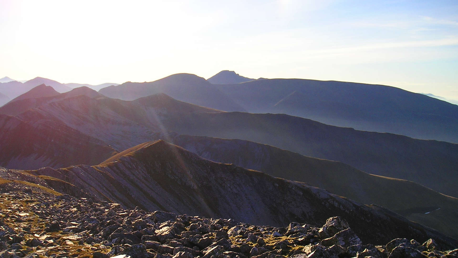
9. Ben Nevis

Looking up the Carn Mor Dearg arete to Ben Nevis
Leaving Carn Mor Dearg's cairn behind, aim southwards on rocky ground following the narrow crest. A path meanders a route, sometimes keeping to the west side of the crest to avoid any difficulties. As ground levels out, the route continues to stick to the crest, occasionally keeping to the east side to avoid exposure.
The lowest point on the ridge is reached and the route ahead looks a bit tougher as the red granite of Carn Mor Dearg is left behind. Uphill, the rock-scrambling is pretty easy keeping to the crest, but if windy, there are opt-out options on the south-east of the crest.
The ground begins to level and become easier. A large cairn is reached  - this is where the top of the 'abseil posts' used to mark a route into Coire Leis. Ahead lies 1,000ft of ascent up bouldery ground to reach the summit of Ben Nevis
  .
.
10. Descent to Glen Nevis

Descending Ben Nevis's Mountain Track
The next part of the route follows the Mountain Track and after the fairly quiet routes on the Grey Corries, the Aonachs and Carn Mor Dearg, the likely crowds and bussle on Ben Nevis will come as a bit of a shock !
In mist, careful compass work is needed to avoid Gardyloo Gully ! So from the summit trig point walk on a bearing of for 231o for 150m, then aim 282o, keeping the large cairns just on your left.
Follow the very obvious Mountain Track route down Ben Nevis past Red Burn and the Halfway Lochan into Glen Nevis.
Route profile »

Maps and GPX downloads »


|
Download GPX of route |
Information on maps and GPX files is on this page.
The map images above link to items on Amazon. A small commission is earned on any map purchased which helps fund the operating costs of this website.
Weather forecasts »
| Regional | MWIS - Western Highlands |
| Peak specific | Mountain Forecast.com Met Office YR.no |
| Seasonal | SAIS - Lochaber Midge forecast |
Alternative and nearby routes »
Lochaber 4000s | |

|
Together Ben Nevis, Carn Mor Dearg, Aonach Mor and Aonach Beag are referred to as the Lochaber 4000s and bagging them in one day makes for a long and varied route hiking on vast plateaux and scrambling along narrow ridges while taking in vast views. Peaks : 4 Munros
Ascent : 2220m (7280ft) Distance : 20km (12m) Time : 8:45hr |
Grey Corries from Corriechoille | |

|
The 'Grey Corries' is the name given to the superb range mountains to the east of Ben Nevis and the Lochaber 4000ers. The Grey Corries are probably seen at their finest from above Spean Bridge with the quartzite rock shimmering in sunshine and framed with the Commando Memorial in the foreground. Peaks : 4 Munros
Ascent : 1800m (5910ft) Distance : 25km (16m) Time : 9:15hr |
The 'Aonachs' from Nevis Range hiking route | |

|
Aonach Mor and Aonach Beag are affectionately known as the 'Aonachs' and a straightforward and direct route these high Munro peaks is from the Nevis Range below Aonach Mor's northern grassy flank. Peaks : 2 Munros
Ascent : 1450m (4760ft) Distance : 15km (9m) Time : 6hr |
Easains from Corriechoille | |

|
Often referred to as just the 'Easains', Stob Coire Easain and Stob a'Choire Mheadhoin are most likely to be tackled on their own from Fersit. However, heading in from Corriechoille not only shows another side to these Munros but also gives the option of also bagging a couple of rugged Corbetts, Cruach Innse and Sgurr Innse. Peaks : 2 Munros, 2 Corbetts
Ascent : 1900m (6230ft) Distance : 20km (12m) Time : 8:20hr |


