

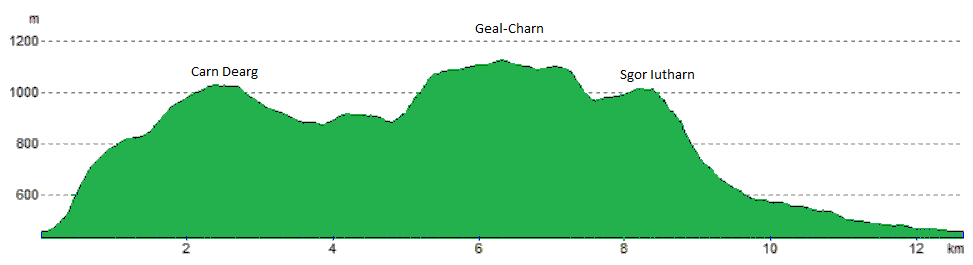
Geal-Chàrn via the Lancet Edge
Hillwalking route from Culra via the Lancet Edge up Geal-Charn, then over Beinn Eibhinn, Càrn Dearg and Aonach Beag on a fine linear ridge.
Route outline
| Munros | ||||
| Walk ascent | 930m (3050ft) | |||
| distance | 13km (8m) | |||
| time | 5:00hr | |||
| Bike ascent | 400m (1310ft) | |||
| distance | 31km (19m) | |||
| time | 1:30hr | |||
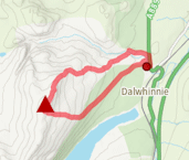
| Start/finish | Dalwhinnie, Highland Grid Ref : NN663846 | |||
| Terrain |
| |||
| Nav |
| |||
| Effort |
| |||
| Scenery |
| |||


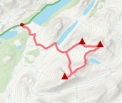
Probably the finest way to explore Geal-Chàrn and the neighbouring Munros is to be based by Culra Bothy for a couple of nights, taking in the Geal-Chàrn group of four Munros in one day and the Ben Alder group on the other day. For the Geal-Chàrn group, this gives the opportunity this huge mountain by heading up (or down) the sharp ridge above Culra known as the Lancet Edge. There's some fairly easy scrambling on this ridge.
There's a conundrum however - how to fit in the nearby Munros of Aonach Beag and Beinn èibhinn ?
Show map
Route description
1. Getting to Dalwhinnie

Bridge under railway at Dalwhinnie
By car, Dalwhinnie is just off the A9, half way between Perth and Inverness. Alternatively arrive by train, all the way from Euston if you need !
In Dalwhinnie, head up the road to towards the railway station, turning left just before it and continue along 'Alder Road' past some houses to the railway crossing. There's a turning circle here and you can usually park just before it.
Unfortunately there is an ongoing access problem over the railway line at this point, and Network Rail are insisting access to Ben Alder Estate should be made via a tunnel 1km to the south. To get here, turn west down a road just south of the petrol station in Dalwhinnie and park before the tunnel avoiding causing any hassle to the houses nearby.
2. Culra Bothy

Carn Dearg above Loch Pattack
From Dalwhinnie, cycle from the crossing down the lochside on the fine estate track that hugs the western shore of Loch Ericht. Just before meeting the third gate-house, turn right uphill and continue to the highest point on the track and Culra Bothy  can be seen ahead in the far distance. There are some wonderful spots to wild-camp by the Allt a'Chaoil-reidhe.

Camping at Culra, Lancet Edge on right
Camping at Culra, Lancet Edge on right
3. Càrn Dearg

Heading up Càrn Dearg, Lancet Edge on right
From Culra Bothy, aim north-west, directly uphill. The ground is heather-clad, although patches of grass can be picked up to ease the slog. After around 300m of ascent the gradient easies and the north-eastern shoulder of Càrn Dearg comes into view.
Upon reaching Càrn Dearg's north-east shoulder, a path can be picked up and followed onto Càrn Dearg's grassy covered summit plateau meeting up with its large summit cairn  shortly thereafter.
4. Geal-Charn

Geal-Chàrn from Càrn Dearg
Leaving Càrn Dearg's summit cairn behind, and continuing south-west along the summit plateau, you'll come to another cairn, from where bouldery terrain is encountered. No avoiding this unfortunately !
Below the boulderfield, terrain is much easier and a delightful hike leads over Diollaid a'Chairn  (a Munro Top) to the ridge between Loch Coire Cheap and Loch an Sgòir. Ahead a steep climb up a narrow ridge leads towards Geal-Charn, there is a path zig-zagging all the way - beware, in winter this can cornice over !
A small cairn  marks the top of the ridge and the edge of the vast plateau that is Geal-Chàrn. From the cairn, a bearing of appx 242o and a distance of 1km will get you onto Geal-Chàrn's summit
  marked by a cairn perched above Coire na Coichille. Note that this last 1km in mist will require some good navigation skills !
Decision tìme ! Head over the remaining Munros of Aonach Beag and Beinn Eibhinn, or tackle the Lancet Edge ?
5. Lancet Edge

The Lancet Edge and Geal-Chàrn from near Culra
From Geal-Chàrn's summit, aim on a bearing of 94o for just short of 1km, which will take you to the top of the drop that leads down to Sgòr Iutharn. Grassy ground initially as you begin descending leads to unavoidable boulderfield, but easily negotiated.
The bealach reached, a walk on flat terrain heads to the Munro Top of Sgòr Iutharn  . The descent down the Lancet Edge is pretty straightforward with some sections of easy scrambling. There are traces of a faint path to follow on the way, with some excellent views.
At the bottom of the ridge, head down to the fine path following the northern bank of Allt a'Bhealaich Dhuibh, cross the burn  coming out of Loch an Sgòir and return to Culra.
6. Aonach Beag

Looking back along to Geal-Chàrn from Aonach Beag
From Geal-Chàrn's summit, head south-west and follow a path along the crest above Coire na Coichille. The route drops to a bealach, from where it's a mere 100m to climb to reach the broad summit of Aonach Beag  , the cairn being a slight dog-leg to the right (the path is a bit vague on the summit).
7. Beinn Eibhinn

Beinn èibhinn from the east
Ahead is Beinn Eibhinn, a shapely mountain crest encircling a coire above the small dark lochan, Lochan a'Charra Mhòir. From Aonach Beag's summit aim due south-west and drop down just over 100m on a well-worn path to a bealach.
The path climbs up the dome ahead and then reaches a flat area with significant drops to Lochan a'Charra Mhòir on the right. The base of the final climb up Beinn èibhinn is reached  , from where the path leads onto the summit
  . Superb views from this summit !
8. Return to Culra

Aonach Beag above Coire a'Charra Bhig
Leave Beinn èibhinn's summit and return to where the start of the final climb began . Leave the crest and drop down loose grass covered steep ground south-east. As the gradient easies, turn east and pick up the eastern shoulder of Beinn èibhinn to follow downhill. It's grass covered and a pleasant jog.
Cross the burn coming down from Coire a'Charra Bhig, then the Uisge Labhair  .
.
Briefly climb the hillside directly infront and meet up with a well-defined path  that travels from Culra to Ben Alder Cottage on Loch Ericht. Follow this path north-east up to Bealach Dubh and back to Culra .
Route profile »
Maps and GPX downloads »


|
Download GPX of route |

|
Open route in OS Maps |
The map images above link to items on Amazon. A small commission is earned on any map purchased which helps fund the operating costs of this website.
Weather forecasts »
| Regional | MWIS - Western Highlands |
| Peak specific | Mountain Forecast.com Met Office YR.no |
| Seasonal | SAIS - Creag Meagaidh Midge forecast |
Alternative and nearby routes »
Ben Alder Forest Munros | |

|
Bike and hike from Dalwhinnie into Ben Alder Forest, cycling Loch Ericht then bagging 6 Munros on high plateaux, ridges and lochans from Culra. Peaks : 6 Munros
Ascent : 2400m (7870ft) Distance : 56km (35m) Time : 11:5hr |
Ben Alder via the Long Leachas | |

|
Rock-scrambling route up Ben Alder via the Long Leachas ridge, a straightforward scramble, adding Beinn Bheòil for a superb Munro circuit. Peaks : 2 Munros
Ascent : 1475m (4840ft) Distance : 48km (30m) Time : 7:30hr |
The Fara and Meall nan Eagan | |
|
This Dalwhinnie hillwalking circuit leads to The Fara’s large summit cairn and superb views and also takes in nearby Graham, Meall nan Eagan. Peaks : 1 Corbett, 1 Fiona
Ascent : 550m (1800ft) Distance : 11km (7m) Time : 3:40hr |
Ardverikie and Loch Laggan Munros | |
|
Bike and hike over Beinn a’ Chlachair, Geal Chàrn and Creag Pitridh, the three Munros of the wild Ardverikie Forest between Laggan and Alder. Peaks : 3 Munros
Ascent : 1350m (4430ft) Distance : 26km (16m) Time : 7hr |
Càrn Dearg and Sgòr Gaibhre | |

|
Bike-hike from Loch Eigheach to Càrn Dearg and Sgòr Gaibhre above Rannoch Forest, with an option to detour to Corbett Meall na Meoig. Peaks : 2 Munros, option of 1 Corbett
Ascent : 1270m (4170ft) Distance : 27km (17m) Time : 5:10hr |


