

West of Glenshee
Route over 3 Munros west of Glenshee. Càrn Aosda and The Cairnwell make an easy outing, extended with Càrn a’ Ghèoidh for a longer day.
Route outline
| Munros | ||||
| Ascent | 625m (2050ft) | |||
| Distance | 11km (7m) | |||
| Time | 3:50hr | |||
| Start/finish | Glenshee Ski Centre Grid Ref : NO139782 | |||
| Terrain |
| |||
| Nav |
| |||
| Effort |
| |||
| Scenery |
| |||


The Glenshee Ski Centre sits at 650m above sea-level overlooked by several Munros, including Càrn Aosda and The Cairnwell. Hiking these two Munros from the ski centre makes for one of the easiest Munro days with only 400m of ascent in under 5km ! Extend the route to include nearby Càrn a' Ghèoidh in more remote surroundings makes for something a tad more challenging and interesting !
Show map

Route description
1. Getting to Glenshee

Càrn Aosda above the Glenshee Ski Centre
The A93 connects Perth with Aberdeen, passing through Braemar in Deeside. A few miles south of Braemar, Glenshee Ski Centre is just below the col on the road's highest point. Unless skiing is in full swing, there are usually no problems parking by the ski centre or in the vast rough area east of the road.
2. Càrn Aosda

Descending Carn Aosda
From the back of the main buildings of the Glenshee Ski Centre, head up a bulldozed track aiming west. Not long after passing a building, the track splits and a couple of options present themselves :
For a fairly gentle climb, take the left fork and continue uphill onto the col between Càrn Aosda and The Cairnwell  , where the track meets with another crossing the crest above Coire Butchart. Turn right and follow the track northeast. The track continues onto the crest of Càrn Aosda, just west of the summit and above the top of the ski-tows.
For a more direct route, keep straight on at the junction above the building and hike close to the Càrn Aosda T-bar climbing fairly steeply. The track eventually meets up with the other track coming from Coire Butchart, above the ski-tows.
A short distance over boulders and stones, reaches the small cairn sitting on Càrn Aosda's summit  .
.
3. Càrn a'Gheoidh

Càrn a' Ghèoidh from the lochans to the north-east
From Càrn Aosda's summit, return down the wide track south-west around the top of the ski-tows and down the bealach just above Coire Butchart and Loch Vrotacha.
If thinking of just bagging The Cairnwell, just stay on the track and follow it all the way to the top of the chair-lift  and onto the summit
  !
!
Alternatively, for a longer and more interesting day, from the bealach , look for a faint path on the right of the track aiming due south.
This crosses wet ground and climbs a few metres to the col  between the Cairnwell and Càrn nan Sac.
A well-defined path crossed the col - turn right and follow this path south-west to the second of two lochans  just north of Càrn nan Sac. Turn around the south edge of this lochan, following a fainter path aiming directly towards Càrn a'Ghèoidh. The path continues over delightful grass-covered ground with only one short steep section on the final approach to Càrn a'Ghèoidh's summit
  .
.
4. The Cairnwell

The Cairnwell from the col below Càrn nan Sac
From Càrn a'Ghèoidh retrace your steps back to the lochans and then to the bealach between Càrn nan Sac and The Cairnwell .
At the bealach, directly ahead look for a scarred path that initially climbs uphill. Follow this as it then turns right (south-east) and cuts a route through heather and stones. As ascent levels out, the path meets up with a ski-run and line of snow fencing.
Follow the ski-run past the top of the Cairnwell Chairlift and continue on a rough track uphill to the huts, masts and weather-station on Cairnwell's summit . Although rather untidy, the Cairnwell's summit is a fine viewpoint in all directions.
5. Return to Glenshee ski centre
It's fairly straightforward to descend directly from Cairnwell downhill to the mast by the snow-gate.This is grassy most of the way with some small patches boulderfield to contend with.
Alternatively for a slightly softer descent, retrace your steps from the Cairnwell's summit for around 200m to just beyond the top of the Cairnwell Chairlift, then make a beeline north-east down grassy slopes to Glenshee Ski Centre directly below.
A third more gentle, but longer option would be to follow the ski-run from the Cairnwell down to the top of Coire Butchart then turn east and hike down another track/ski-run back to Glenshee Ski Centre.
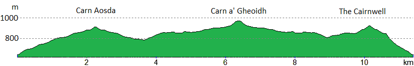
Route profile »
Maps and GPX downloads »


|
Download GPX of route |

|
Open route in OS Maps |
The map images above link to items on Amazon. A small commission is earned on any map purchased which helps fund the operating costs of this website.
Weather forecasts »
| Regional | MWIS - Southeast Highlands |
| Peak specific | Mountain Forecast.com Met Office YR.no |
| Seasonal | SAIS - Southern Cairngorms Midge forecast |
Alternative and nearby routes »
Glenshee 9 Munros | |

|
Long high-level route linking the 9 Munros above Glenshee. With grassy slopes, this is one of the easier multi-Munro circuits, and a hill race. Peaks : 9 Munros
Ascent : 1690m (5540ft) Distance : 30km (19m) Time : 10:15hr |
Morrone from Braemar | |

|
A short hillwalk from Braemar up a fine, if rather rough path to the top of Morrone - a superb viewpoint to survey the southern Cairngorms. Peaks : 1 Corbett
Ascent : 480m (1570ft) Distance : 6km (4m) Time : 2:25hr |
Glas Tulaichean and Càrn an Righ | |

|
Route up Glas Tulaichean and Càrn an Rìgh from Spittal of Glenshee. Estate tracks and clear paths ease the way to these two fine Munros. Peaks : 2 Munros
Ascent : 1170m (3840ft) Distance : 23km (14m) Time : 7:40hr |
Ben Gulabin from Spittal of Glenshee | |

|
Hillwalking route up Ben Gulabin from Spittal of Glenshee. A short, straightforward climb on estate tracks and a worn path all the way to the summit. Peaks : 1 Corbett, option to extend
Ascent : 450m (1480ft) Distance : 5km (3m) Time : 2hr |
An Socach from Baddoch | |

|
Hillwalking route up An Socach from Glen Clunie near Braemar. A detached Munro south of Glen Ey, climbed directly from Baddoch. Peaks : 1 Munro
Ascent : 610m (2000ft) Distance : 15km (9m) Time : 5:45hr |


