

Loch Arkaig Corbetts hillwalking route
Tackle the Corbetts of Sgùrr Mhurlagain, Fraoch Bheinn and Sgùrr Cos na Breachd-laoidh above Loch Arkaig in rugged Rough Bounds of Knoydart.
Route outline
| Corbetts | ||||
| Ascent | 1900m (6230ft) | |||
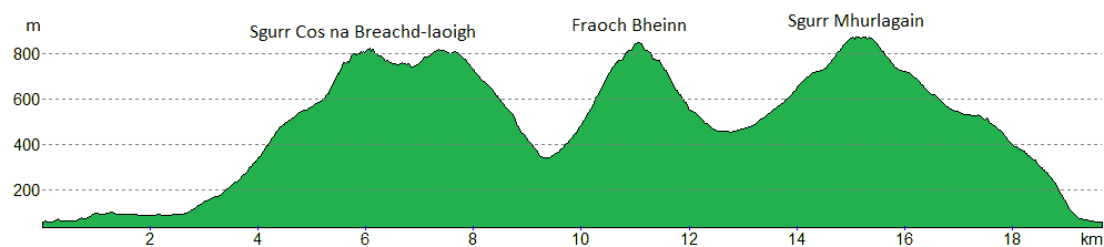
| Distance | 20km (12m) | |||
| Time | 8:10hr | |||
| Start/finish | Western end of Loch Arkaig Grid Ref : NM988916 | |||
| Terrain |
| |||
| Nav |
| |||
| Effort |
| |||
| Scenery |
| |||


The remote and wild area west of Loch Arkaig, is a rugged and mountainous area, often referred to as the Rough Bounds of Knoydart. On the edge of this, rise the three Corbett peaks of Sgùrr Cos na Breachd-laoidh, Fraoch Bheinn and Sgùrr Mhurlagain, their grass-covered slopes scarred with crags and rocky outcrops.
The three Corbetts are quite distinct and as such involve a fair bit of ascent up pathless grassy slopes. Higher up an old wall and iron fence-lines aid navigation eastwards from Sgùrr Cos na Breachd-laoigh to Druim a' Chuirn, but otherwise there are no tracks or paths along the hill-crests.
Show map

Route description
1. Getting to Loch Arkaig

At the western end of Loch Arkaig
In the Great Glen, Gairlochy and its locks on the Caledonian Canal sit a couple of miles west of the Commando Memorial above Spean Bridge.
From Gairlochy the narrow B8005 heads up to Loch Lochy's southern tip then turns westwards. From here on a very narrow and unclassified road a 12 mile drive travels through the mossy Mile Dorcha then hugs the northern shores of Loch Arkaig to its western end.
The road ends by a gate across the access to an estate track, just before which is a large parking area with designated bays for around 15 vehicles. If the car-park is full, there are various verge side parking areas before reaching the car-park, but care should be taken not to block passing places.
2. Sgùrr Cos na Breachd-laoidh

Heading along Glen Dessarry towards Sgurr Cos na Breachd-laoigh
Leave the car-park, head around the gate and begin hiking up the estate track.
After just under 1km, the track comes to a junction  by a few right-of-way signs - keep right as the track climbs uphill for a few metres.
The track drops down to the River Dessarry where the twin summits of Sgùrr Cos na Breachd-laoidh and Druim a' Chùirn overlooking Coire Chicheanais dominate the view ahead.
Continue hiking along the track for another 1km or so toward the estate house and outbuildings of Glendessarry  . Just before reaching the buildings and after crossing a bridge over the Allt na Feithe, turn off the track and head uphill on a faint grassy track by a target practice area.
The track heads through a knackered old fence line then splits - take the left fork. A short distance further on, the track disappears into long grass - just continue over damp ground and cross the Allt Coire Chicheanais where suitable.
Now on the south-eastern shoulder of Sgùrr Cos na Breachd-laoidh, follow its crest as it rises continuously up to the Corbett's complex summit with puddles and fine views.

On Sgùrr Cos na Breachd-laoidh, view to Sgùrr Mor
 sits by the corner of a wall that rises up from Sgùrr Cos na Breachd-laoidh's north-western shoulder - this shoulder connects to An Eag on the Sgùrr Nan Coireachan to Sgùrr Mòr ridge.
On Sgùrr Cos na Breachd-laoidh, view to Sgùrr Mor
3. Fraoch Bheinn

the 'obilisk' on Druim a' Chuirn
From Sgùrr Cos na Breachd-laoidh's summit cairn, follow the remains of the wall and iron fence-posts north-east along the hill's mainly grass-covered crest. Some height is lost and the low point between the summit and the eastern top, Druim a' Chùirn is reached, where what appears from below to be a volcanic plug, reveals its true origin - just shattered rock  .
.
A hike up a gentle grassy crest leads to Druim a' Chùirn's top  , where the wall turns north-east and is therefore left behind for a descent down Druim a' Chùirn's south-east shoulder. No path, but no difficulties ahead, just a drop of 450m to flat ground where the Allt and Feithe
  is crossed.

On Fraoch Bheinn looking to Bidein a' Chabair and Càrn Mor
 , a grassy bank gently rises from right to left (south to north), aim for this and when reached, follow it up onto the crest of Fraoch Bheinn's southern shoulder. A faint path is picked up and followed northwards to the small cairn on the summit
  - a fine viewpoint due to this hill's isolated position.
On Fraoch Bheinn looking to Bidein a' Chabair and Càrn Mor
4. Sgùrr Mhurlagain

Route down Coire na Cioche Bige
On Fraoch Bheinn's summit, about turn and retrace your steps back to where you arrived on the crest, then continue southwards dropping a bit more height until reaching fairly safe terrain above Coire na Cioche Bige  .
.
Turn eastwards and begin to head down into Coire na Cioche Bige - there are some rocky ledges, but these are easily by-passed or gone around to reach the flat ground of Feith a' Bhrolaich  .
.
Some soggy ground, then a couple of lines of ATV tracks are crossed before ground ahead begins to rise. A bit of a trudge of a hike up a grass covered slope for the next 1km leads up onto Sgùrr Mhùrlagain's wide south-western shoulder, where a faint path can be found to follow for another 1km to the hill's summit crest.

Summit of Sgùrr Mhurlagain
 .
.Summit of Sgùrr Mhurlagain
5. Return to Loch Arkaig

Looking down Sgùrr Mhùrlagain's south-western shoulder
Sgùrr Mhùrlagain can be descended from virtually any point aiming southwards, but if you're heading directly back to the car-park at the western end of Loch Arkaig, prepare for a slog !
Re-trace your steps back down the south-western shoulder of Sgùrr Mhùrlagain to where you came onto the crest, then continue for a further 2km south-west until a fence  is met. Cross the fence and aim due south down steeper terrain to meet with the road above Loch Arkaig to walk back along to the car-park.
Route profile »
Maps and GPX downloads »


|
Download GPX of route |

|
Open route in OS Maps |
Information on maps and GPX files is on this page.
The map images above link to items on Amazon. A small commission is earned on any map purchased which helps fund the operating costs of this website.
Weather forecasts »
| Regional | MWIS - Northwest Highlands |
| Peak specific | Mountain Forecast.com Met Office YR.no |
| Seasonal | SAIS - Lochaber Midge forecast |
Alternative and nearby routes »
Gairich & Sgùrr Mòr via Glen Kingie | |

|
Bike and hike along Glen Kingie to Gairich, Sgùrr an Fhuarain and Sgùrr Mòr on the edge of the Rough Bounds of Knoydart. Peaks : 2 Munros, 1 Corbett
Ascent : 2245m (7370ft) Distance : 49km (30m) Time : 9:5hr |
Sgùrr Mòr and Sgùrr an Fhuarain from Loch Arkaig | |

|
Hike from Loch Arkaig on stalker's tracks and paths to Sgùrr Mòr and Sgùrr an Fhuarain in the edge of the Rough Bounds of Knoydart's. Peaks : 2 Munros
Ascent : 1500m (4920ft) Distance : 21km (13m) Time : 7:45hr |
Mullach Coire nan Geur-oirean hillwalk | Loch Arkaig | |

|
Lochside cycle from Loch Arkaig followed by hill walk along Druim na Giuthsaich ridge to reach Mullach Coire nan Geur-oirean. Peaks : 1 Fiona/Graham
Ascent : 920m (3020ft) Distance : 32km (20m) Time : 4:30hr |
Càrn Mòr bike and hike via Glen Dessarry | |

|
Scenic bike and hike via Glen Dessary to Càrn Mòr above the head of Loch Morar and on the edge of the Rough Bounds of Knoydart. Peaks : 1 Corbett
Ascent : 1035m (3400ft) Distance : 25km (16m) Time : 4:45hr |
Glen Dessarry Munros traverse | |

|
Bike along Glen Dessary to hike and scramble the Rough Bounds Munros of Sgùrr na Cìche, Garbh Chìoch Mòr, and Sgùrr nan Coireachan. Peaks : 3 Munros
Ascent : 1510m (4950ft) Distance : 29km (18m) Time : 7hr |


