Glen Lyon Munros
Hiking route up the Munros north of Glen Lyon: Meall na Aighean, Càrn Mairg, Meall Garbh and Càrn Gorm, with option to extend to the Corbett Beinn Dearg nearby.
Route outline
| Munros | ||||
| Corbetts | ||||
| Ascent | 1450m (4750ft) | |||
| Distance | 17km (11m) | |||
| Time | 6:40hr | |||
| Start/finish | Invervar, Glen Lyon Grid Ref : NN666482 | |||
| Terrain |
| |||
| Nav |
| |||
| Effort |
| |||
| Scenery |
| |||
Fine views are had from all of the summits, with the views west from Càrn Gorm to Meall Ghaordie and beyond, and north from Meall Garbh to Alder and Drumochter being particularly worthy.
I find the circuit is best done anti-clockwise as, for the most part, you'll face the westerly mountainous views, unlike the more flat distant ground that is viewed to the east. Access may be an issue in this area (search for North Chesthill Estate for more info).
Show map
Route description
1. Getting to Invervar

Start from Invervar
North of Loch Tay an unclassified road heads westwards from picturesque Fortingall with its thatched cottages near Aberfeldy. This road travels along the length of Glen Lyon and ends by the dam at the easterrn end of Loch Lyon.
On this road, around 7km west from Fortingall, is the hamlet of Invervar, from where this hillroute begins.
After the Covid Lockdowns of the early 2020s, many roads in Perthshire were slapped with 'Clearway' to curb irresponsible parking. The 2 mile stretch of road around Invervar is unfortuantely one of these roads and on my last visit to the area, the small car-park by the red phone-box in Invervar was blocked off.
The nearest parking spots outwith the 'Clearway' are an off-road layby 1km west of Invervar and some rough ground by a corner in the road 1km east of Invervar close to an old telephone exchange.
2. Meall na Aighean (Creag Mhòr on older maps)

Looking up the south-west shoulder of Meall na Aighean
In Invervar, just to the east of the old bridge over Invervar Burn, a sign on the north side of the road points the way up to the hills, initially through a patch of ground around the back of some houses.
The route joins with a rough track and begins to head up through felled forestry and rhodedendrons.
At the end of the forested land  it's onto a more pleasant track and out to open hillside.
Walk a few metres up the track and look for a faint path off right heading directly up the western shoulder of Meall na Aighean. Follow this path over grass, then as it makes a way through heather.
At one point, the path splits - don't take the left fork as this is a direct descent route from Càrn Mairg (described in 'Escape routes'). Keep heading directly uphill on the crest. The heather becomes more stunted higher up and the south-west summit of Meall na Aighean can be bypassed.
A faint path continues eastwards over Meall na Aighean's grassy plateau to its rocky main summit  .
On older maps, you may find Meall na Aighean refered to as Creag Mhòr - the name belongs to a minor top to the south-east.
3. Càrn Mairg

Path leading to Càrn Mairg
From Meall na Aighean return towards the dip between its two summits, then head off right (north-west). An obvious path develops and picked up heading northwards towards Càrn Mairg.
The path crosses a wide grassy bealach and aims for the col  between Càrn Mairg and its nearby minor summit of Meall Liath. At this bealach turn westwards and head for the boulders below Càrn Mairg's summit.
Clamber up boulders and reach Càrn Mairg's summit  with its two cairns.
4. Meall Garbh

Summit of Meall Garbh
From Càrn Mairg, navigation is pretty straightforward for a fair distance - it's more or less a case of following a line of fence-posts !
From the summit of Càrn Mairg, head north-west and pick up the line of posts. Keeping to the left of the line of posts as they continue north-west, the ground is grass-covered and easy underfoot and a path can be followed.
The path turns westwards and further on patches of bouldery ground are crossed.
Over the flat top of Meall a' Bhàrr  , the path and posts then take a sharp turn north-west. Around 500m further on, the path turns westwards and drops though heather covered ground to eventually arrive at the foot of Meall Garbh after passing a lochan
  . Follow the path westwards and uphill bypassing Meall Garbh's minor south-east top.
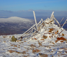
Meall Garbh's summit cairn  is reached - it is made entirely of old iron posts ! Decent views from here, with the southern aspect of Schiehallion given a fine show.
5. Càrn Gorm

Approaching the summit of Càrn Gorm
Leave Meall Garbh following the fence-posts.
As the posts start to turn north-west  , leave them and follow the faint path to the bealach Leave Meall Garbh following the fence-posts initially westwards.
After dropping around 50m, the line of posts changes direction and turns north-west  , leave them at this point and drop south-west following a faint path to the bealach
  below the minor top of An Sgòrr
  .
.
At the bealach, there's a choice - two paths contour around the north-west side of An Sgòrr and another heads over it.
Either way, all paths eventually lead to the bealach  west of An Sgòrr and below Càrn Gorm. There's a broken line of rusty posts heading up to from Invervar Burn to this point.
Heading up the northern shoulder of Càrn Gorm, the line of posts disappears abruptly, but a faint path is followed onwards to Càrn Gorm's summit  .
.
On Càrn Gorm's summit, two cairns sit on the crest, of which the northerly one has a trig point, now broken from its base. Both summits offer little in the way of shelter against north-westerly winds.
6. Return to Invervar

The track by Invervar Burn
From Càrn Gorm's summit, continue following the path as it makes a way down the mountain's south-east shoulder. The path is a hill-runner's delight !
After dropping around 500m, the edge of forestry above Invervar is reached  , just before which ground begins to become quite sodden. Walk north-east tracing the forest bounderay then drop to a shoogly bridge
  over Invervar Burn.
Cross the bridge and follow an old track downhill. The track improves with height lost and reaches the gap in the forest  earlier, from where retrace your steps back to Invervar.
7. Escape routes

Post marking path of hut by Allt Coire a'Chearcaill
Direct descent (or ascent) from Càrn Mairg
From the summit of Càrn Mairg  , turn south-south-west and clamber down some bouldery ground.
Reach grassy ground below, then descend over heather to drop down to a hut
  by the Allt Coire a'Chearcaill.
From here, a good path travels downwards to meet up with the path used to head up Meall nan Aighenan.
Direct ascent (or descent) to Meall Garbh
From Invervar, head up on the track through the forest to the bridge  over Invervar Burn.
Keeping to the northern side of Invervar Burn and you'll come to an old corrugated hut, from where the track becomes fainter. The path continues onwards north-west to the base of An Sgòrr
  , from where continue north-west on pathless ground to gain the col
  between An Sgòrr and Meall Garbh.
8. Detour to Beinn Dearg

Beinn Dearg from Càrn Gorm
More commonly ascended on its own from Innerwick, the nearby Corbett of Beinn Dearg can instead be tagged on to day bagging the Glen Lyon Munros. Although the start and end points of such a day are a few kilometres apart, there is only 200m of additional ascent.
This route begins from just west of the forest of Camusvrachan, where a track heads up over farmland into the trees. Following this track leads through the forest and up to open heathery hillside  .
.
Simply hike uphill to the summit of Beinn Dearg  with its fine views south onto the Lawers group.
To progress to Càrn Gorm, just drop north, then north east to the col at the top of Dubh Choirein  , from where it is a steep trudge up to the north-west arm of Càrn Gorm.
Route profile »

Maps and GPX downloads »

|
Download GPX of route |

|
Open route in OS Maps |
The map images above link to items on Amazon. A small commission is earned on any map purchased which helps fund the operating costs of this website.
Weather forecasts »
| Regional | MWIS - Southeast Highlands |
| Peak specific | Mountain Forecast.com Met Office YR.no |
| Seasonal | SAIS - Glencoe Midge forecast |
Alternative and nearby routes »
Ben Lawers Range | |

|
Hillwalking route over all 7 Munros of the Lawers range, including Ben Lawers, Meall Corranaich, An Stùc and Meall Garbh, in a long day’s hike. Peaks : 7 Munros
Ascent : 1750m (5740ft) Distance : 19km (12m) Time : 7:30hr |
Schiehallion from Braes of Foss | |

|
Hillwalking route up Schiehallion from Braes of Foss. A popular, fairly easy Munro and distinctive peak - often the first Munro for many hillwalkers. Peaks : 1 Munro
Ascent : 750m (2460ft) Distance : 10km (6m) Time : 3:45hr |
Meall Tairneachan and Farragon Hill | |

|
Hillwalking route from Loch Tummel up Meall Tairneachan and Farragon Hill. Overgrown trails and old tracks give character to this Corbett double. Peaks : 2 Corbetts
Ascent : 1100m (3610ft) Distance : 17km (11m) Time : 6:10hr |
Innerwick Corbetts | |

|
Hillwalking route from Glen Lyon up Cam Chreag and Beinn Dearg, following estate tracks then short grassy climbs to the Corbett summits. Peaks : 1 Corbett
Ascent : 755m (2480ft) Distance : 13km (8m) Time : 4:30hr |


