
Strathconon Corbetts
North of Strathfarrar and Monar, Strathconon stretches eastwards, above which Meallan nan Uan and Sgùrr a' Mhuilinn encircle the hidden loch of Coire Mhuilinn.
Route outline
| Corbetts | ||||
| Ascent | 1300m (4260ft) | |||
| Distance | 15km (9m) | |||
| Time | 5:55hr | |||
| Start/finish | Church Wood, Strathconon Grid Ref : NH292538 | |||
| Terrain |
| |||
| Nav |
| |||
| Effort |
| |||
| Scenery |
| |||


Although there are four prominant peaks in this tight group of hills, only Sgùrr a' Mhuilinn and Meallan nan Uan are afforded Corbett status. Sgùrr a' Choire-rainich and Sgùrr a' Ghlas Leathaid miss out on the classification, but omitting them from a hike while here would be a shame as the views west and east from these peaks are uninterupted and quite vast. A visit to hidden Loch Coire a' Mhuilinn is also highly recommended !
There are some steep slopes and very little in the way of obvious paths to aid progress, therefore navigation can be testing in misty conditions.
Show map

Route description
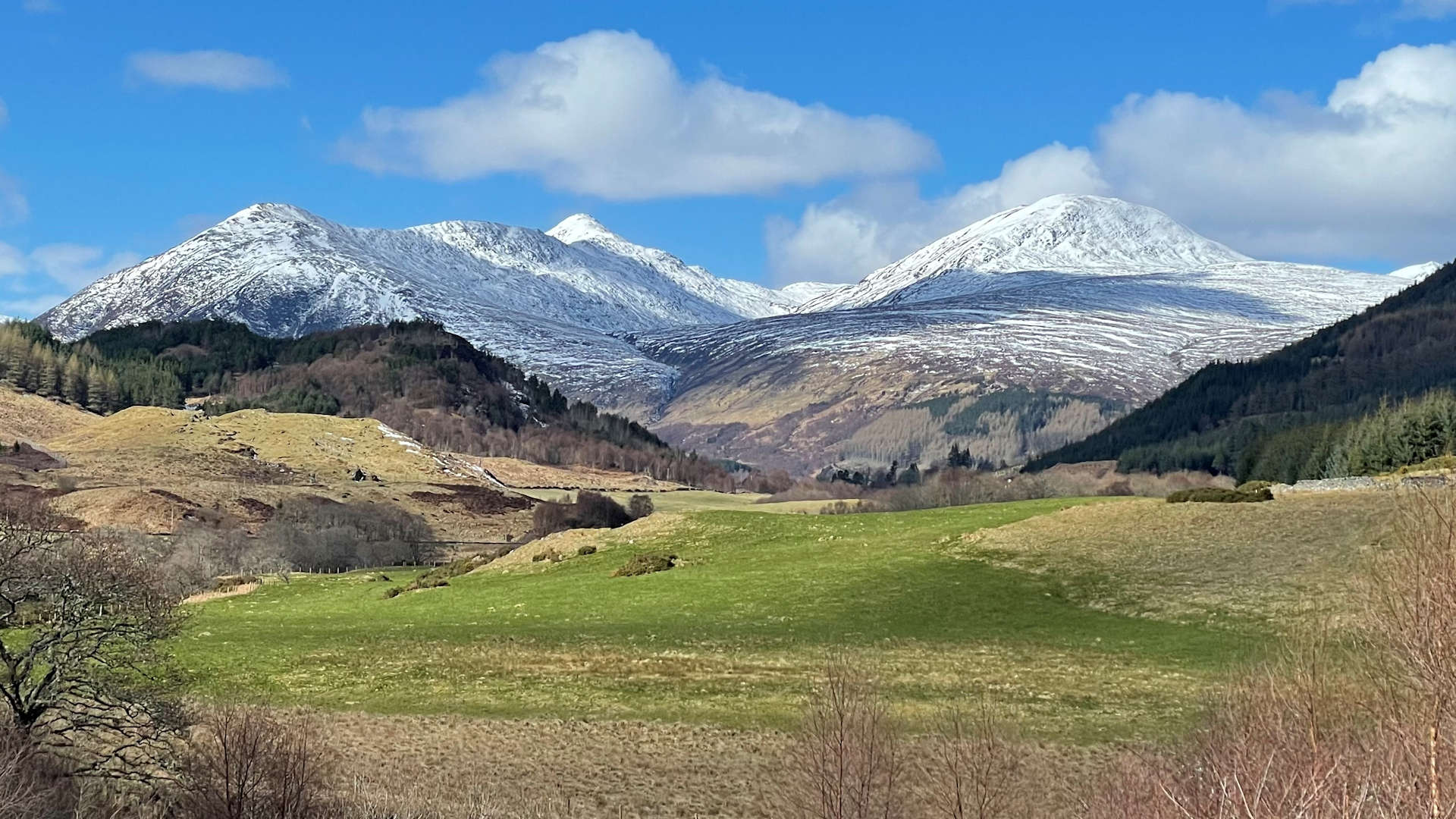
1. Getting to Strathconon and Church Wood

Church Wood in Strathconon
West of Inverness, the A832 heads through Muir of Ord to Marybank, beyond which is Strathconon. This rather lovely glen has little lochs and hydro schemes, aside which travels an unclassified and narrow road.
Just beyond the settlements of Bridgend and Milton are the road of houses of Strathanmore. There is parking marked for hillwalkers here, or 1km further south is a small parking area by a sign for Church Wood.
2. Meallan nan Uan

Strathconon and Ben Wyvis on way up Creag Ruadh
Starting from the roadside by Church Wood, follow a vague path directly uphill around some woodland. The path quickly disappears ! Keeping to the crest ahead, clamber uphill over grass and heather, sometimes quite steeply, while avoiding rocky outcrops.
There's around 450m of ascent before the gradient easies and a faint path forms heading westwards up Creag Ruadh  . Once on this minor summit, Meallan nan Uan can be seen ahead with the path, now more obvious, making a route directly along the hill crest.

Meallan nan Uan from Creag Ruadh
 is crossed before turning westwards for the final 100m of ascent up to Meallan nan Uan's summit
  , where a small cairn rests and from where fine views can be had.
Meallan nan Uan from Creag Ruadh
3. Sgùrr a' Ghlas Leathaid and Sgùrr a' Choire-rainich

Sgùrr a' Ghlas Leathaid and Sgùrr a' Choire-rainich
From Meallan nan Uan continue westwards along the crest of the hill for 200m or so, before turning north-west and beginning to lose height. Drop to the ground above Coir' a' Mhuilinn where the little bump of Carnan Fuar  forces a route to be made either directly over it, or contouring around it - on both occassions I've been here I did the latter, but if in poor visibility, possibly better to cross directly over it.
Beyond Carnan Fuar, a direct route could be made up Sgùrr a' Mhuilinn - fine for a quick day out, however, you'd missing out on the uninterupted views from the westerly peaks in this group - Sgùrr a' Ghlas Leathaid and Sgùrr a' Choire-rainich !
Aim north-west, contouring around Sgùrr a' Mhuilinn. There is no path to follow, but the terrain underfoot is the main delightfully soft and grass covered. The foot of Sgùrr a' Ghlas Leathaid  is reached, up which a direct ascent to its summit is fairly straightforward.

Sgùrr a' Mhuilinn from Sgùrr a' Ghlas Leathaid
 and climbs Sgùrr a' Choire-rainich
  . A small untidy cairn rests here, from where superb views can be savoured westwards.
Sgùrr a' Mhuilinn from Sgùrr a' Ghlas Leathaid
4. Sgùrr a' Mhuilinn

Looking back to Sgùrr a' Ghlas Leathaid and Sgùrr a' Choire-rainich from Sgùrr a' Mhuilinn
To avoid some crags on Sgùrr a' Choire-rainich's south-east face, from its summit, about turn and re-trace your steps for a short distance. Turn due south and drop to safer ground below Bealach Gaoithe, then turn south-east to drop further to Bealach na Siunnachair  .
.

View east from Sgùrr a' Mhuilinn
 and onto a wide grass-covered crest that leads up a gentle incline all the way to Sgùrr a' Mhuilinn's complex summit
  .
.View east from Sgùrr a' Mhuilinn
5. Return to Strathconon

Meallan nan Uan from Sgùrr a' Mhuilinn's summit
The direct route down from Sgùrr a'Mhuilinn heads south-east and is fairly obvious following a faint path to the Allt an t-Srathain Mhòir.
A more enjoyable descent can be made by heading south-west from Sgùrr a' Mhuilinn's summit towards Carnan Fuar and then dropping to the shores of Loch Coire a' Mhuilinn  - this is a special place, hidden from roadside view and from where the views back up to the Corbett peaks are stunning ! As with the direct route down, this route meets with the Allt an t-Srathain Mhoir, aside which is a faint path.

By the shore of Loch Coire a' Mhuilinn
By the shore of Loch Coire a' Mhuilinn
Route profile »

Maps and GPX downloads »


|
Download GPX of route |

|
Open route in OS Maps |
The map images above link to items on Amazon. A small commission is earned on any map purchased which helps fund the operating costs of this website.
Weather forecasts »
| Regional | MWIS - Northwest Highlands |
| Peak specific | Mountain Forecast.com Met Office YR.no |
| Seasonal | SAIS - Torridon Midge forecast |
Alternative and nearby routes »
Meall na Faochaig and Beinn Mheadhoin from Strathconon | |

|
From Inverchoran in Strathconon, two short hillwalking routes head up the Fionas Meall na Faochaig and Beinn Mheadhoin Peaks : 2 Fionas
Ascent : 1100m (3610ft) Distance : 16km (10m) Time : 5:45hr |
Bac an Eich and An Sìthean | |

|
Old stalkers paths help access the Corbetts Bac an Eich and An Sìthean which are tucked away in a remote area between Loch Monar and Strathconon. Peaks : 2 Corbetts
Ascent : 1200m (3940ft) Distance : 31km (19m) Time : 9:45hr |
Càrn na Còinnich from Strathconon | |

|
Hillwalking route from Bridgend onto the high ground between Strathconon and Glen Orrin to reach Càrn na Còinnich and its neighbour Meall a' Bhogair Mòr. Peaks : 1 Fiona
Ascent : 750m (2460ft) Distance : 14km (9m) Time : 4:45hr |
Strathfarrar Munros | |

|
A quiet road from Struy in Strathglass leads to a circular hillwalking route that bags Sgùrr a' Choire Ghlais and the Strathfarrar Munros. Peaks : 4 Munros
Ascent : 1580m (5180ft) Distance : 17km (11m) Time : 6:55hr |
Maoile Lunndaidh from Strathfarrar | |

|
Fine paths above Loch Monar lead to Maoile Lunndaidh's base from where an old stalkers path travels towards its summit. A detour can be made to An Sìthean. Peaks : 1 Munro, option of 1 Corbett
Ascent : 1350m (4430ft) Distance : 25km (16m) Time : 8:15hr |


