

Broad Law to Dollar Law
Hiking route up Broad Law, Cramalt Craig and Dollar Law from Megget Stone. Fencelines aid navigation across the rolling Southern Uplands.
Route outline
| Corbetts | ||||
| Donalds | ||||
| Other hills | ||||
| Ascent | 810m (2650ft) | |||
| Distance | 16km (10m) | |||
| Time | 5:20hr | |||
| Start | Megget Reservoir Grid Ref : NT196232 | |||
| Finish | Megget Stone Grid Ref : NT151203 | |||
| Terrain |
| |||
| Nav |
| |||
| Effort |
| |||
| Scenery |
| |||


Ranges of rolling grass-covered hills twist and turn in the lands between Peebles and Moffat, on which Broad Law is the highest point. Fine access points for starting a hike up Broad Law are by Tweedsmuir and Megget reservoir.
This route begins from Megget reservoir, from where a fine estate track leads onto high ground and meets with fencelines. Most of the route traces faint paths following the fencelines over gentle climbs and descents and as such navigation is pretty straightforward.
Show map

Route description
1. Getting to Megget Reservoir

Cattle-grid by the Megget Stone
This hillwalking route up Dollar Law and Broad Law approaches from the Megget reservoir and the Megget Stone to the south of the hills. The start and finish of the route lie some 5km apart, therefore organising some shared transport or use of a bike will cut out an hours walk along tarmac at the end of the day.
Megget reservoir can be accessed from Tweedsmuir on the A701, where a narrow, well maintained road heads south-east along Talla Reservoir, then climbs steeply to the Megget Stone by the highest point on the road.
Alternatively, the area can be accessed from the A708 near St Mary's Loch from where a narrow road along the Megget reservoir is followed to the road's highest point.
The hillroute starts from an inlet near Megget reservoir's eastern end, where close by there is ample parking in a picnic area above the lochside. The route ends 5km to the west of the start point, by a cattle grid close to the highest point on the road, where parking is limited to a couple of cars, though more parking for around 5 or 6 cars is available 300m further west.
2. Dollar Law

Cramalt Craig from Cramalt Burn
Starting by the bridge over the Cramalt Burn at the inlet near the eastern end of Megget Reservoir, head through a gate by a patch of woodland. On a fine estate track travelling north-west, folllow the east bank of the burn uphill.
The track climbs gently for around 2km, then turns northwards around Stone Grain Rig and begins to climb more steeply. After 1km travelling northwards, the track begins to curve in a more westerly direction - note that this is shown correctly on the OS Explorer map, but not on the OS Landranger map !

On Dollar Law's summit, looking back over Fifescar Knowe
 , around halfway between the minor summits of Dùn Law and Fifescar Knowe, where a fence-line is met. Turn right and follow a faint trod northwards as it hugs the fence-line for 1.5km, crossing another fenceline on Fifescar Knowe
  on the way before reaching Dollar Law's summit
  . The summit is marked by a trig point sitting between the fenceline and the remains of an old wall.
On Dollar Law's summit, looking back over Fifescar Knowe
3. Cramalt Craig and Broad Law

Fenceline on Cramalt Craig with Broad Law in mist
Navigation for the remainder of the route is fairly straightforward, even in mist or white-out, tracing a fence-line all the way !
On Dollar Law, about-turn and trace your route back over Fifescar Know to the top of the estate track. Continue following the fence-line southwards to Dùn Law, after which there is a shallow drop, before a climb up Cramalt Craig  . Cramalt Craig's summit is marked by a small cairn close to a turn in the fenceline.
Still keeping close to the fence-line, lose a height of just under 150m while traversing Middle Hill to reach the bealach between Cramalt Craig and Broad Law, crossing a fenceline running north-south on the way. If the drop had been just a few metres more, Cramalt Craig might have been classified a 'Corbett' rather than just a 'Donald' !

Broad Law summit beacon with Culter Fell beyond
 on Broad Law's wide summit plateau. There are three masts and a huge circular beacon on the plateau, with the highest point marked by a trig point
  just south of the beacon. Views are pretty good !
Broad Law summit beacon with Culter Fell beyond
4. Return

Beginning a descent southwards from Broad Law
From the trig point, aim southwards following the fenceline for 2km. There are some ATV tracks to follow instead - these pull slightly westwards away from the fenceline before returning on the descent to Cairn Law.
Just below Cairn Law, the fenceline meets with a tall deer fence  - don't head through the gate in this fence, instead keep to the east side of the fence line, picking up a faint path by the shepherd's cairns.
The path, slight soggy in bits, hugs the fenceline and becomes more obvious as it drops over Fans Law to the roadside by the Cattle Grid and Megget Stone.
5. Alternative route avoiding road return

View from Clockmore over Megget Reservoir
To avoid the need for transport arrangements or bringing a bike for the 5km road walk, an alternative there-and-back route can be made from near the western end of Megget reservoir.
At the western end of the reservoir, a bridge crosses Linghope Burn, with roadside parking available just west of the bridge. Begin your walk from the east side of the bridge. In winter and spring, a fence leading up to a gate is visible - though in summer and autumn it may be obscured by vegetation. Head uphill to the gate, then continue climbing the grassy, heather-covered slope to reach Clockmore  .
.
From here, follow the crest of Cramalt Craig's southeastern spur, aiming northwest over Pykestone Knowe. ATV tracks can be picked up at around a height of 650m leading to the bend in the fenceline by Cramalt Craig's summit.

Broad Law and Cramalt Craig from above Pykestone Knowe
Broad Law and Cramalt Craig from above Pykestone Knowe
6. Alternative approach via Talla Cleuch Head

Talla Cleuch Head from the reservoir
To the west of Megget Reservoir, the narrow single-track road twists its way over the hills before dropping steeply down to Talla reservoir and continuing northwards to Tweedsmuir. Rising from the shores of Talla reservoir is Talla Cleuch Head, a grass-covered Donald that branches off from the southern ridge of Broad Law. This peak offers an excellent alternative approach to Broad Law or can be climbed as a rewarding short outing in its own right.
The walk begins from the roadside around the midpoint of Talla Reservoir, where a large deer fence runs along the base of the hillside. A gate in the fence allows access to open ground. From here, follow a faint ATV track up through long grass, heading steadily eastwards up the hillside. The route is straightforward, leading directly to the crest near the summit of Talla Cleuch Head, its unmarked top  lying on the west side of a deer fence, a short distance north of a gate.
For those continuing to Broad Law, pass through the gate just south of the summit and follow the fence-line southeastwards then eastwards towards Cairn Law , joining the more common southern ridge route to Broad Law's summit.
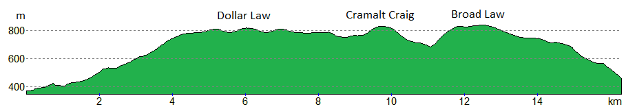
Route profile »
Maps and GPX downloads »


|
Download GPX of route |

|
Open route in OS Maps |
The map images above link to items on Amazon. A small commission is earned on any map purchased which helps fund the operating costs of this website.
Weather forecasts »
| Regional | MWIS - Southern Uplands |
| Peak specific | Mountain Forecast.com Met Office YR.no |
| Seasonal | Midge forecast |
Alternative and nearby routes »
Black Law and Dollar Law | |

|
Hillwalking route from Black Law to Dollar Law above Manor Water: tough trackless eastern half contrasts with easier grassy crests and clear paths west. Peaks : 3 Donalds, 5 Donald Tops
Ascent : 1030m (3380ft) Distance : 17km (11m) Time : 6hr |
Pykestone Hill from Manor Water | |

|
Hillwalking route up Pykestone Hill and Middle Hill from Manor Water, a quiet walk above Peebles with secluded corries and wide southern views. Peaks : 2 Donalds, 3 Donald Tops
Ascent : 600m (1970ft) Distance : 12km (7m) Time : 4hr |
White Coomb and Hartfell | |

|
Hillwalking route from the Grey Mare's Tail up White Coomb and Hart Fell. A fine hike from the dramatic waterfall near Moffat onto high rolling hills. Peaks : 2 Corbetts
Ascent : 1050m (3440ft) Distance : 15km (9m) Time : 5:30hr |
Culter Fell and Gathersnow Hill | |

|
Hillwalking route in the Culter Hills south of Biggar around Coulter Reservoir, over grassy summits including Culter Fell and Gathersnow Hill. Peaks : 2 Fionas, 4 Donalds
Ascent : 960m (3150ft) Distance : 19km (12m) Time : 6:30hr |
Dùn Rig and the Glen Sax Circuit | |

|
Circular hillwalking route from Peebles over Dùn Rig, Huddleshope Heights and the Glen Sax hills, part of which forms the Gypsy Glen Race. Peaks : 1 Fiona, 4 Donalds
Ascent : 900m (2950ft) Distance : 21km (13m) Time : 6:45hr |


