

Mount Keen from Glen Tanar
Biking and hiking route up Mount Keen from Glen Tanar
Fine tracks following the old drove road through forests of Scots Pine lead to the "Mounth Road" and to Mount Keen's summit. The use of a bike for the 13km plus cycle to the foot of Mount Keen is recommended !
Route outline
| Munros | ||||
| Walk ascent | 410m (1340ft) | |||
| distance | 4km (2m) | |||
| time | 1:45hr | |||
| Bike ascent | 400m (1310ft) | |||
| distance | 27km (17m) | |||
| time | 1:45hr | |||
| Start/finish | Glen Tanar Grid Ref : NO479965 | |||
| Terrain |
| |||
| Nav |
| |||
| Effort |
| |||
| Scenery |
| |||


The most popular route up Mount Keen comes in from Glen Mark to the south, but this slightly quieter route heads in from Glen Tanar to the north. Like the Glen Mark route, most of the way is on fine estate tracks and well maintained paths, but the scenery is quite different - with a fair amount of the way is through delightful woodland and forestry following the Water of Tanar. The Glen Tanar Visitor centre is worth visiting and a wander around the old church and cemetary is worthwhile.
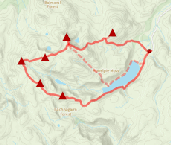
Show map
Route description
1. Getting to Glen Tanar

Best to keep straight on !
West of Aberdeen, Aboyne lies on the River Dee and just south-west of the village an unclassified road leads to Glen Tanar. At the end of public access on this road is a car-park from where the route up Mount Keen begins. Parking is £3 for a day (Tuesdays free !).
2. Cycle to Shiel of Glen Tanar

The 'Halfway Hut'
From the car-park, head 100m back along the road then cross the bridge over the Water of Tanar. Immediately to the left is Glen Tanar visitor centre and its ranger service.Take the track to the right and cycle south past Glen Tanar Church and cemetary  to a junction and turn right.
The track comes to another junction  by a bridge over Water of Tanar and right-of-way sign pointing to "Glen Esk by the Mounth") - you can take either route - I prefer straight on as the track is smoother.A further 1km, the track splits
  - keep left (to the right is the old track which has been badly erroded by the river).
The track comes to another junction  , turn sharp right and cross the bridge over the Water of Allachy. Shortly thereafter yet another junction and bridge
  , turn left heading west alongside the north bank of Water of Tanar.
Around 2½km further on you'll pass a small wooden shack, the "Half Way Hut"  and as its name suggests, you're now around halfway to the foot of Mount Keen ! Shortly after this you'll come out of the forest and get your first view of Mount Keen ahead.
Another bridge  is reached, with the track crossing onto the southern bank of the Water of Tanar. After a brief cycle of 1km, yet another bridge
  is crossed, this time it's back onto the northern bank for 1.5km to a right-of-way sign pointing to Mount Keen near a fairly new metal bridge
  . Once over this, the track gets much rougher and begins to climb fairly steeply uphill, so perhaps best to leave bikes just beyond this bridge.
3. Mount Keen

Leaving Mount Road, last climb to Mount Keen's summit
The now rough but obvious track is followed uphill and comes to a grate  . Beyond this, a fine path has been constructed with side sections around culverts enabling accomplished mtb-ers to continue (see glentanar.co.uk for info on the reconstructed path).
At around c700m  , the path splits - the 'Mounth Road' heads off right around the summit dome of Mount Keen and a footpath heads directly ahead uphill aiming for the summit. This final section is made of rocks and boulders carefully placed and twists and turns until Mount Keen's trig point
  comes into view.
4. Return to Glen Tanar

Mount Keen's summit
Return by the same route. The cycle for the most part is a gentle downhill and therefore easier than the route in.
Route profile »

Maps and GPX downloads »

|
Download GPX of route |
Information on maps and GPX files is on this page.
The map images above link to items on Amazon. A small commission is earned on any map purchased which helps fund the operating costs of this website.
Weather forecasts »
| Regional | MWIS - Southeast Highlands |
| Peak specific | Mountain Forecast.com Met Office YR.no |
| Seasonal | SAIS - Southern Cairngorms Midge forecast |
Alternative and nearby routes »
Mount Keen from Glen Mark | |

|
This is the most popular route up Mount Keen and begins along estate tracks through Glen Mark on which the use of a bike is recommended. Higher up well maintained paths make for a straightforward route to Mount Keen's summit. Peaks : 1 Munro
Ascent : 700m (2300ft) Distance : 16km (10m) Time : 2:30hr |
Lochnagar and Loch Muick circuit | |
|
A group of five Munros surround Loch Muick in Royal Deeside. Including mighty Lochnagar, these peaks form a terrific high-level hiking circuit. Peaks : 5 Munros, 1 Corbett
Ascent : 1340m (4400ft) Distance : 28km (17m) Time : 9:15hr |
Morven hillwalking and race route | |

|
The shortest and direct route up Morven begins from near Logie Coldstone in Cromar and takes the form of a steep heathery trudge followed by a gentle hike over a wide crest. This route is also used for the ascent on the Morven Hill Race, with a detour for the descent. Peaks : 1 Corbett
Ascent : 660m (2170ft) Distance : 9km (6m) Time : 3:20hr |
Clachnaben and Mount Battock | |

|
Heading from Glen Dye to Mount Battock via the granite tor of Clachnaben makes for an enjoyable hike on an elevated expanse. Clachnaben Hill Race is also outlined on this page. Peaks : 1 Corbett
Ascent : 1050m (3440ft) Distance : 25km (16m) Time : 8hr |


