
Meall Chuaich from Glen Tromie
Hiking route up Meall Chuaich from Drumguish. Cycle through Glen Tromie then a short 600m hike to the large cairn on Meall Chuaich’s summit.
Route outline
| Munros | ||||
| Walk ascent | 160m (520ft) | |||
| distance | 2km (1m) | |||
| time | 0:30hr | |||
| Bike ascent | 620m (2030ft) | |||
| distance | 29km (18m) | |||
| time | 2:15hr | |||
| Start/finish | Drumguish, Insh Grid Ref : NN792997 | |||
| Terrain |
| |||
| Nav |
| |||
| Effort |
| |||
| Scenery |
| |||


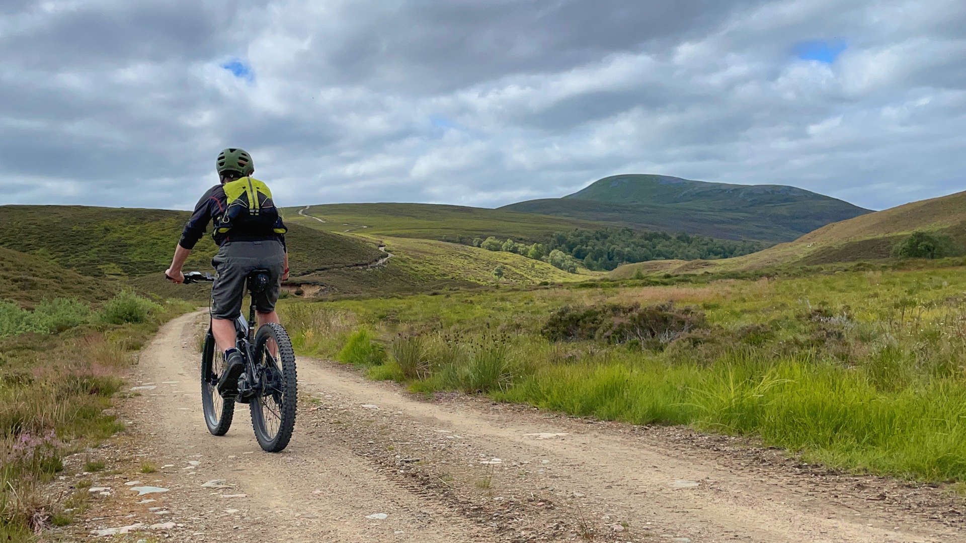
When biking down the estate tracks through pretty Glen Tromie, Meall Chuaich is the grass-covered hump that appears directly ahead for most of the way down the glen. The closer the hill gets, the more obvious the track up its north-eastern shoulder appears.
This route makes use of these estate tracks which lead most of the way up Meall Chuaich to within 600m of the summit leaving a climb up a grassy slope of a mere 150m.
Navigation is straightforward, but it is worth noting that this route crosses over two maps, so either both the Landranger or both the Explorer maps listed below will be needed.
With the bridge over the River Tromie behind Bhran Cottage being damaged by storms a few years ago and since not repaired, currently this route can only be done if river levels are low allowing for the river to be forded safely.
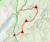
Show map
Route description
1. Getting to Drumguish

Forests by Drumguish
The B970 travels along the southern bank of the River Spey, linking Kingussie to Aviemore. On this, around 4km south-east of Kingussie, the road twists sharply as it crosses the River Tromie via an old bridge (no parking here).
Around 500m north of the bridge, a sign points east to Drumguish. Drive uphill on a narrow road into woodland and park somewhere appropriate, without causing obstruction, before reaching the houses at Drumguish.
2. Bhran Cottage

Bhran Cottage and bridge over River Tromie pre-2023.
On bike, cycle up the narrow road to the crossroads in the heart of Drumguish. Turn right and head downhill on a rough track to join the main estate track  through Glen Tromie.
Now on a fine, fairly flat estate track, cycle down delightful Glen Tromie. The journey is around 9km, the first half of which is on track to Lynaberack Lodge - a rather 1970's housing-estate looking building and a bit out of place in such a beautiful area !
Beyond the lodge it's on tarmac all the way to Bhran Cottage  . On the way the fast flowing River Tromie begins to hug the track and the last tìme I was here, a fair number of behives were standing close to the river just before reaching Bhran Cottage.
3. Meall Chuaich
.")
Ford on River Tromie (by Cat Wright).
To the western side of Bhran Cottage, a track drops down to some woodland and to the River Tromie. A rather rickety bridge used to cross the fast flowing water at this point, but unfortunately the bridge was heavily damaged in autumn '23 and the remains of the iron frame currently lies opposite Bhran Cottage.
On the OS maps there is a footbridge marked around 250m upstream of Bhran Cottage. Alas, this has long disappeared with only the concrete foundations on both banks surviving.
On the eastern side of Bhran Cottage another track leads down to the river where there is a ford of sorts, though this will not be crossable if the river is in spate.
Onto the southern side of the River Tromie, the track is picked up again, heads out of woodland and after a short distance, begins to climb. Through a gate in a deer-fence, around a corner, the track does a couple of short little climbs before leveling out to a more easy gradient as it ascends around 150m over the next 1.5km.
The constructed track ends abruptly on Càrn an Fheòir Bhuidhe  .
.

Approaching the final climb up Meall Chuaich
 .
.
Steep to begin with, the rough rutts of the track climb uphill, before leveling out and crossing grass covered ground to reach a final climb up the hill
 . I left my bike here, then on foot aimed uphill, climbing a mere 150m up a grassy slope to reach Meall Chuaich's summit plateau with its large cairn
  standing on the highest point.
Approaching the final climb up Meall Chuaich
4. Return

Descending Meall Chuaich
Return is by the same route.
Once back on bike, the effort made on the uphill is rewarded by some really enjoyable downhill free-wheeling !
Route profile »

Maps and GPX downloads »


|
Download GPX of route |

|
Open route in OS Maps |
The map images above link to items on Amazon. A small commission is earned on any map purchased which helps fund the operating costs of this website.
Weather forecasts »
| Regional | MWIS - Southeast Highlands |
| Peak specific | Mountain Forecast.com Met Office YR.no |
| Seasonal | SAIS - Southern Cairngorms Midge forecast |
Alternative and nearby routes »
Meall Chuaich and Creag Ruadh from Dalwhinnie | |

|
Hillwalking route up Meall Chuaich and Creag Ruadh near Dalwhinnie, following estate and hydro tracks to a bothy before a quick ascent to the summits. Peaks : 1 Munro, option of 1 Fiona/Graham
Ascent : 650m (2130ft) Distance : 14km (9m) Time : 3:35hr |
Càrn Dearg Mòr and Meallach Mhor | |

|
From Drumguish, a cycle through quiet Glen Tromie, then a hike over heather and grass reaches the remote Corbetts Càrn Dearg Mòr and Meallach Mhòr. Peaks : 2 Corbetts
Ascent : 1040m (3410ft) Distance : 41km (25m) Time : 6:45hr |
Leathad an Taobhain from Glen Feshie | |

|
Bike through beautiful Glen Feshie on estate tracks, then a steep push gets close to Leathad an Taobhain, leaving a short hike to the summit. Peaks : 1 Corbett
Ascent : 900m (2950ft) Distance : 33km (21m) Time : 4:20hr |
An Dùn and A' Chaoirnich | |

|
Biking and hiking route above Gaick Pass. Cycle estate tracks to Loch an Duin, then hike faint paths to the remote Corbetts A' Chaoirnich and An Dùn. Peaks : 2 Corbetts
Ascent : 1190m (3900ft) Distance : 53km (33m) Time : 5:30hr |
East of Drumochter | |
|
Linear hillwalking route over Càrn na Caim, A’ Bhuidheanach Bheag and Meall Chuaich east of Drumochter. Transport helps as start and finish are 11km apart. Peaks : 3 Munros
Ascent : 1100m (3610ft) Distance : 25km (16m) Time : 8:10hr |


