

Beinn Enaiglair from Braemore
Hillwalking route up Beinn Enaiglair from Braemore Junction. Estate tracks then a pathless circular route over heather slopes lead to fine viewpoints.
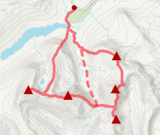
Route outline
| Corbetts | ||||
| Ascent | 740m (2420ft) | |||
| Distance | 12km (8m) | |||
| Time | 4:15hr | |||
| Start/finish | Braemore Junction Grid Ref : NH209777 | |||
| Terrain |
| |||
| Nav |
| |||
| Effort |
| |||
| Scenery |
| |||


To the west of mighty Beinn Dearg, sits little Beinn Enaiglair above Lael Forest. Hiking up this delightful hill is a fine way to spend a few hours while savouring some stunning views out west to Coigach.
Decent estate tracks access the base of Beinn Enaiglair and continue further around the hill. Higher up there are only occasional traces of trods to follow, but terrain is fairly light underfoot and navigation is straightforward.
Show map
Route description
1. Getting to Braemore Junction

Braemore gatehouse by the junction
Around 12km south of Ullapool, the main A835 trunk road meets with the A832 by Braemore junction, beside which is a large car-parking area and the entrance to Braemore Estate.
On the A832, 1km on from Braemore junction, is another car-parking area which is for Corrieshalloch Gorge and the Falls of Messach - a visit to this via the constructed footpaths and viewing platforms is highly recommended.
2. Beinn Enaiglair

Waterfall on the Allt a' Chumhainn
From Braemore junction car-park, head to Braemore Estate gate-house, then follow a fine track heading north-west. After around 1.5km the track comes to the entrance for the main estate house  , just before which there is a junction with another track heading off right and uphill.
Follow this other track as it passes another smaller house and some outbuildings then continues through some forestry, to meet with a gate  in a deer-fence. Through the gate, keep to the track as it passes a loch with boathouse, then climbs gently with Beinn Enaiglair in view ahead. Passing a grass-topped dyke, the track comes to a cairn
  - leave the track here and follow a faint path directly uphill and above the Allt a' Chumhainn with a few lovely little waterfalls.

Beinn Dearg from Beinn Enaiglair's summit
 . Leave the path at this col and over grassy terrain, climb up fairly steep ground between rocky outcrops. Higher up the ascent easies and a faint path can be picked up to follow to Beinn Enaiglair's summit
  . Fine views from the top, but with being on a fairly large plateau, you may have to wander a bit to get the best pics !
Beinn Dearg from Beinn Enaiglair's summit
3. Return

View from Beinn Enaiglair's western cairn
A straightforward return can be made by re-tracing your steps back down Beinn Enaiglair's southern slopes.
On my most recent visit I opted to head along Beinn Enaiglair's north-western shoulder in order to savour more views over Coigach. After pausing by the cairn  on a minor rise and around 1km on from the summit, I turned westwards and enjoyed a fine downhill run over heather and grass. I reached the track
  around 1km north where it was left earlier and followed it southwards to the cairn by the Allt a' Chumhainn and retraced my steps back.
On my first tìme up Beinn Enaiglair, we were in fine conditions and had plenty of time, so opted to extend our planned route up to Beinn Dearg. Easier than expected, we went over Iorguill and followed the 'destitution wall' to Beinn Dearg's summit followed by a return out via Clach na h-Aide.
Route profile »

Maps and GPX downloads »


|
Download GPX of route |

|
Open route in OS Maps |
The map images above link to items on Amazon. A small commission is earned on any map purchased which helps fund the operating costs of this website.
Weather forecasts »
| Regional | MWIS - Northwest Highlands |
| Peak specific | Mountain Forecast.com Met Office YR.no |
| Seasonal | SAIS - Torridon Midge forecast |
Alternative and nearby routes »
Inverlael Munros | |

|
Hillwalking route up Beinn Dearg and neighbouring Munros from Inverlael. Tracks and old paths lead into vast forests to this bouldery Munro dome. Peaks : 6 Munros
Ascent : 2600m (8530ft) Distance : 35km (22m) Time : 13hr |
Creag Rainich from Loch a' Bhraoin | |

|
Hillwalking route from Loch a’ Bhraoin up Creag Rainich. A straightforward climb on grass-covered slopes to the Corbett summit above the loch. Peaks : 1 Corbett
Ascent : 840m (2760ft) Distance : 17km (11m) Time : 5:40hr |
Am Faochagach from Loch Glascarnoch | |

|
Hillwalking route up Am Faochagach from Loch Glascarnoch. A direct line over soggy ground and faint paths, with ATV tracks on wide grassy crests. Peaks : 1 Munro
Ascent : 780m (2560ft) Distance : 15km (9m) Time : 5hr |
Western Fannichs | |
|
Hillwalking route on the western Fannichs, tracing ridges above corries to 5 Munros including Sgurr nan Clach Geala, the highest and most distinctive. Peaks : 5 Munros
Ascent : 1840m (6040ft) Distance : 23km (14m) Time : 8:50hr |
An Teallach | |

|
Hillwalking route on An Teallach, with moderate scrambling along its famous ridge to reach Munro summits Bidein a' Ghlas Thuill and Sgùrr Fiona. Peaks : 2 Munros
Ascent : 1270m (4170ft) Distance : 13km (8m) Time : 5:20hr |


