
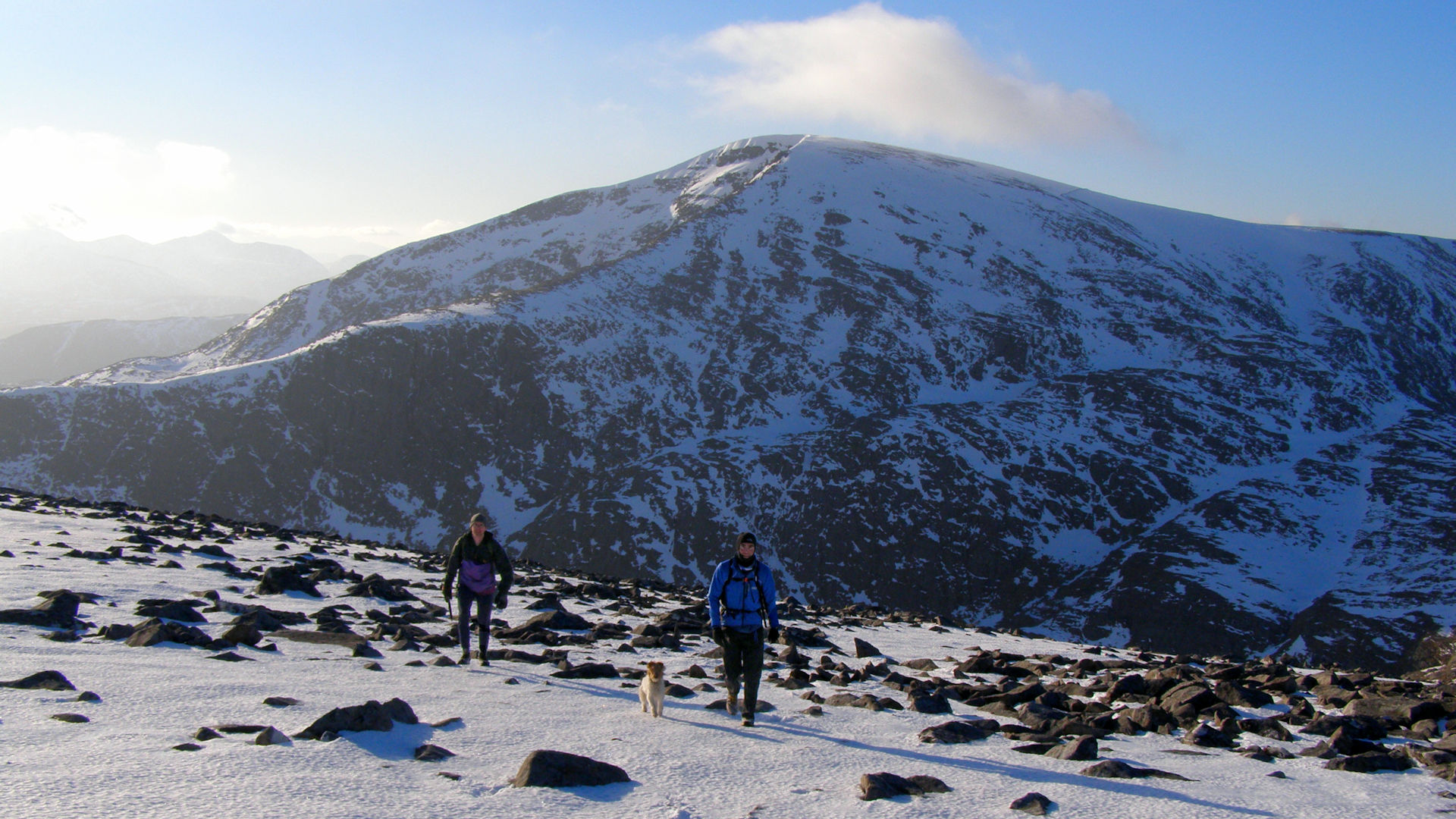
Inverlael Munros
Hillwalking route up Beinn Dearg and neighbouring Munros from Inverlael. Tracks and old paths lead into vast forests to this bouldery Munro dome.
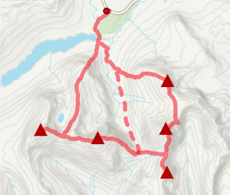
Route outline
| Munros | ||||
| Fionas | ||||
| Ascent | 2600m (8530ft) | |||
| Distance | 35km (22m) | |||
| Time | 13:00hr | |||
| Start | Inverlael, Loch Broom Grid Ref : NH182853 | |||
| Finish | Abhainn an Torrain Duibh Grid Ref : NH277743 | |||
| Terrain |
| |||
| Nav |
| |||
| Effort |
| |||
| Scenery |
| |||


Beinn Dearg is vast mountain at the centre of a group of Munros that lie in Inverlael and Strath Vaich forests. These mountains rise above deep corries in where stalkers paths can be followed up to higher ground.
There are some stunning landforms and interesting remnants of past-times to be found while navigation is tested when away from stalkers paths.
One of my favourite epic hill-running routes that can be divided into a shorter outings if needed.
Show map

Route description
1. Getting to Inverlael
Inverlael lies around 10km south of Ullapool on the A835, where a there is a hill-walker's car-park. There is a height barrier at the entrance to the car-park preventing access to campervans and other high vehicles.
If hiking the full route, this ends by the weather station at the western end of Loch Glascarnoch, some 16 km south-east from Inverlael, therefore a bike or other transport arrangements will ideally need to be organised.
The route can be shortened to return to Inverlael, however this would require Am Faochagach to be dropped from the itinerary.
2. Seana Bhraigh

From the car-park, follow an estate track eastwards into Inverlael Forest and onwards for just over 2km. The track crosses the River Lael, passes an old wall by a sign pointing to Beinn Dearg and comes to a junction  .
.
Keep left at the junction and begin to climb uphill, shortly after which another junction is reached - again keep left.
This track twists and turns as it climbs out of the forest and reaches a gate  . Now on the old stalker's path, follow it for 4km as it climbs 350m and reaches the Allt Gleann a' Mhadaidh
  .
.
Cross the burn and follow the now soggy path above the northern bank of the Allt Gleann a' Mhadaidh for 1km. The path veers away from the burn, climbs over the north-west arm of Eididh nan Clach Geala, then drops slightly into Coire an Lochain Sgeirich.
Sticking to the path, cross the Allt na Creige Duibhe  (stepping stones) and continue around the southern base of Meall Glas an Ruighe to head up to a cairn
  just south of a small lochan
  on a grassy plateau.
Now away from paths, reach the small lochan, then head north-east and descend into a coire.
Past a couple of little lochans, aim east, where the ground starts to level and a faint path is picked up.
Follow this path as it crosses the bealach  at the head of Cadha Dearg and turn northwards in the direction of Seana Bhraigh.
More soggy ground next while hiking uphill and around the south-western side of Seana Bhraigh's minor top marked 906m  .
The peaty bealach
.
The peaty bealach  below Seana Bhraigh is gained from where a faint path is followed to the summit
  with a small cairn. Fantastic views from this spot !

Approaching Seana Bhraigh from the south-east
 - if attempted, requires a bit care while rock-scrambling over loose ground to reach its summit.
Approaching Seana Bhraigh from the south-east
3. Eididh nan Clach Geala

Crossing the moorland near Toman Coinich
Return to the bealach at the head of Cadha Dearg .
From this point there are no paths to follow for around 3km and this combined with fairly featurless ground will test navigation skills !
Aim south-west from the bealach, gradually attaining height.
After hiking around 1 km, rockier ground is met, there's a bit of a climb before gradients begin to level as a plateau at a height of just over 850m is approached.
The minor summit of Toman Choinich  is met, beyond which the crest of its plateau travels west-north-west. Instead of sticking to this crest, aim due west to the burn
  in Coire Gorm, then up grass covered and perhaps soggy ground up Eididh nan Clach Geala's eastern flank.

Eididh nan Clach Geala's cairn with Beinn Dearg behind
 is marked by the eastern cairn.
Eididh nan Clach Geala's cairn with Beinn Dearg behind
4. Meall nan Ceapraichean

Lines of rock below Cean Garbh
Following a faint path, leave Eididh nan Clach Geala's summit behind and head south-east downhill.
The path disappears into grass and sodden ground as the hillside steepens - keep heading south-east down and the path reforms nearing a wet bealach  below.
Cross the bealach, negotiate a burn, and ignore a stalker's path heading east-west.
Turn south and start climbing up wet grassy ground with lines of rock.
Although pathless, a natural line up Ceann Garbh can be found, steadily becoming steeper with progress.

Heading up Meall nan Ceapraichean from Eididh nan Clach Geala
 is reached.
Terrain is slightly easier south-east of this minor summit, so simply make a directly for the cairn on the bouldery top of Meall nan Ceapraichean
is reached.
Terrain is slightly easier south-east of this minor summit, so simply make a directly for the cairn on the bouldery top of Meall nan Ceapraichean  .
.Heading up Meall nan Ceapraichean from Eididh nan Clach Geala
5. Beinn Dearg

Beinn Dearg from the Bealach an Lochain Uaine
From Meall nan Ceapraichean, descend south-east on an obvious and well-worn path through stoney ground.
In less than 1km, the grassy ground and several lochans of the appropiately named Bealach an Lochain Uaine  are encountered.
By the most south-easterly lochan is the base of the "destitution wall"  - a well constructed stone dyke that travels up the base of Beinn Dearg's north-east ridge
  then most of the way up this shoulder. For the most part, follow this wall uphill. There are a few rocky sections an the way that require a bit of a scramble up, though invariably to the right of any of these, a path can be found making an easier if less direct route up.

On the way to Beinn Dearg, just above the 'destitution wall'
 , at which point there is a gap in the wall. Leave the wall behind and on a faint path through stones and grass, aim southwards for the summit of Beinn Dearg.
There's a huge cairn marking the highest point on Beinn Dearg
, at which point there is a gap in the wall. Leave the wall behind and on a faint path through stones and grass, aim southwards for the summit of Beinn Dearg.
There's a huge cairn marking the highest point on Beinn Dearg  , from where views are good. The bulk of the flat summit plateau does block some of the vistas, suggesting a little wandereing from the cairn is needed to get the best views.
On the way to Beinn Dearg, just above the 'destitution wall'
6. Cona' Mheall

Hiking up Cona' Mheall with Beinn Dearg behind
From Beinn Dearg's summit return to the gap in the "destitution wall" and retrace your steps back down to the lochans at Bealach an Lochain Uaine .
At the bealach, cross over the wall to the grassy south side and look for an obvious boot-worn path heading east and downhill.
The path contours below the bump marked with spot height 884m  (or 886m on OS Landranger) and will lead you to the bealach
  below Cona' Mheall.
From the bealach the path continues south-east uphill until it meets with bouldery ground.
The path then turns east and tries to pick a route on grassy ground between boulderfields, but higher up some boulderfields have to be crossed.
The long narrow summit crest of Cona' Mheall is met  around 250m south of the highest point, from where a walk along a bouldery crest reaches the summit
  where a small cairn stands perched above some precipitious drops.
7. Am Faochagach

Descending Cona' Mheall
It's all change for the route onwards from Cona' Mheall - there are no paths of any sort !
From Cona' Mheall's summit, head north slightly and look for a way down between rocks aiming north-east. The first few metres of descent does require a bit of care as the ground is not only steep, but quite loose.
Beyond this first steep section, the gradient lessens and grassy terraces are followed between lines of rock. Beware in mist the route down will require some navigation as these lines of rock have a tendancy to pull away from the crest of Cona' Mheall's eastern shoulder.
As height is dropped, grass and rock lines give way to heather and a faint path forms which is followed down to the southern end of Loch Prille.
Cross the stream  coming out of the lochan, taking some extra care as rocks are slippy and a waterfall thunders just below.
Start climbing up through deep tussock grass and gradually head south-south-east onto Am Faochagach's northern shoulder, from where an unrelenting uphill hike awaits.
The minor rounded summit Meallan Bàn  is met, where a well constructed conical cairn stands around two metres high.

Cairn on Meallan Ban, Am Faochagach beyond
 !
!Cairn on Meallan Ban, Am Faochagach beyond
8. Descend to Loch Glascarnoch

On Am Foachagach's wide southern crest
Leave Am Faochagach's summit and head south-west dropping down a gentle slope to a wide flat area. This is followed by another gentle drop, this tìme through more stoney ground. As the ground levels, it becomes more grass covered and signs of a faint path can be found heading southwards - follow this path for the next 1km or so, crossing a wide plateau.
Ground begins to drop once more, beyond which it levels out again  . Leave the path (more of a track by now) and head south-west. Boulders amongst grass are gone around and a boot-worn path evolves - follow this down. The path becomes more obvious with height lost as it makes a direct route for the level ground at the southern end of Loch Gharbhrain
  .
.
Some soggy ground is crossed, then the path continues around a morraine to meet with the Abhainn a' Gharbhrain . This is usually fairly straightforward to cross, though expect wet feet. It won't however be crossable in spate, in which case, instead head around the northern shores of Loch a' Gharbhrain and make two shallower river crossings by some old shielings.

Crossing the Abhainn a' Gharbhrain, Am Faochagach behind
Crossing the Abhainn a' Gharbhrain, Am Faochagach behind
9. Alternative - leave out Seana Bhraigh

Split in the path in Gleann na Sguaib
Seana Bhraigh can be approached seperately from other directions, through Strath Oykel is to be recommended. In which case the route above can be shortened by aiming direct from Inverlael to Eididh nan Clach Geala .....
Start as described above and when you get to the junction beyond the sign for Beinn Dearg, keep right and continue on the track to the edge of the forest. Out of the forest and now on a constructed path, continue hiking following the River Lael for a further 2km.
The path comes to a junction, also marked with a small cairn  - take the left fork and climb uphill as the path cuts a defined route through heather. The path continues to the bealach above Lochan a' Chnapaich where its joins the above route between Eididh nan Clach Geala and Meall nan Ceapraichean.
10. Alternative - return through Gleann na Sguaib

The 'destitution wall' along Beinn Dearg
If no transport options are available to allow for a return from Loch Glascarnoch to Inverlael, then the route can be altered by missing out Am Faochagach and returning through Gleann na Sguaib .....
Having reached Bealach an Lochain Uaine as described above, alter the route by first heading up Cona' Mheall then returning to the bealach.
Up Beinn Dearg next, then one option is to return to Bealach an Lochain Uaine once more followed by a walk out through Gleann na Sguaib on a rough but decent stalkers path to meet up with the forestry tracks and return to Inverlael.
Alternatively follow the "destitution wall" along Beinn Dearg's north-western shoulder. This wall ends by the 700m contour  , from where moorland is crossed for a further 2km while aiming north-west. Head northwards to descend steep heather-clad slopes back into forestry and onto a forest track
  which meets up with the track back to Inverlael.
11. Alternative - begin with Beinn Bhreac

Eididh nan Clach Geala and Beinn Dearg above gorges and waterfalls
Beinn Bhreac is a modest Graham/Fiona hill lying north-east of Inverlael. It may be climbed either as a there-and-back from Inverlael or as a short detour at the start of the main route described above. Note that the bridge crossing the Allt Mòr, around 2km east of Inverlael, is currently closed due to its poor condition.
The route begins as for the main Inverlael approach, following the estate track into the forest. Around 1km from the car park the track splits - instead of continuing straight on, the left-hand branch is taken, dropping slightly to a pair of bridges. These cross the Allt Mòr where it divides to form a small island between two narrow but impressive gorges.
After crossing the bridges, the track is followed eastwards for just under 2km, ignoring a branch off to the left.
At the next split  , a less obvious track continues directly ahead, climbing steeply into forestry. This track twists as it gains height before emerging at another vehicle track. Crossing this, a further steep section leads to the forest edge and a locked gate
  in the enclosing deer fence, with a side gate located to the left.
Beyond the fence, the track becomes rougher and climbs more gently, with widening views to Eididh nan Clach Geala and Beinn Dearg, and down into a series of gorges where waterfalls tumble below.
Rounding a bend, Beinn Bhreac comes into view, its slopes broad and gently rising, largely covered in heather. The track fades into a pair of ATV lines, which are followed until they turn eastwards  towards a cairn on the moorland skyline.
From the bend, the summit is reached by striking northwards across open heather. Progress can be heavy underfoot, though occasional grassy rakes ease the going. Higher up, a sizeable lochan appears unexpectedly, with the summit cairn lying off to the right.
Beinn Bhreac's summit  offers expansive views, with much of Coigach and Assynt spread out to the west and north and a fine view of Ben Klibreck.
To continue on to either Seana Bhraigh or Eididh nan Clach Geala, a south-eastward line is taken across heathery moorland to join the path in Coire an Lochain Sgeirich.

Coigach from Beinn Bhreac's summit
720m/14km/4:45hr
Coigach from Beinn Bhreac's summit
Route profile »

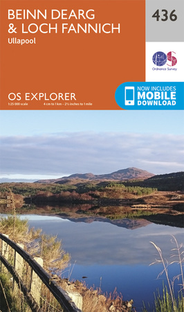
Maps and GPX downloads »


|
Download GPX of route |

|
Open route in OS Maps |
The map images above link to items on Amazon. A small commission is earned on any map purchased which helps fund the operating costs of this website.
Weather forecasts »
| Regional | MWIS - Northwest Highlands |
| Peak specific | Mountain Forecast.com Met Office YR.no |
| Seasonal | SAIS - Torridon Midge forecast |
Alternative and nearby routes »
Am Faochagach from Loch Glascarnoch | |

|
Hillwalking route up Am Faochagach from Loch Glascarnoch. A direct line over soggy ground and faint paths, with ATV tracks on wide grassy crests. Peaks : 1 Munro
Ascent : 780m (2560ft) Distance : 15km (9m) Time : 5hr |
Seana Bhraigh from Corriemulzie | |

|
Hike and bike route up Seana Bhraigh from Oykel Bridge and Corriemulzie. Drive, cycle, then hike heather slopes for the easiest approach to this remote Munro. Peaks : 1 Munro
Ascent : 930m (3050ft) Distance : 27km (17m) Time : 4:30hr |
Beinn Enaiglair from Braemore | |

|
From Braemore Junction, a fine hillwalk over tracks and heather slopes to Beinn Enaiglair, with an optional extension to nearby Meall Doire Fàid. Peaks : 1 Corbett, plus option of 1 Fiona
Ascent : 740m (2430ft) Distance : 12km (7m) Time : 4:15hr |
Càrn Bàn and Beinn a' Chaisteil | |

|
Bike through Alladale’s wild tracks to hike up Càrn Bàn and Beinn a' Chaisteil – remote Corbett hills in the Strathvaich wilderness. Peaks : 2 Corbetts
Ascent : 1400m (4590ft) Distance : 47km (29m) Time : 7:25hr |
Western Fannichs | |
|
Hillwalking route on the western Fannichs, tracing ridges above corries to 5 Munros including Sgurr nan Clach Geala, the highest and most distinctive. Peaks : 5 Munros
Ascent : 1840m (6040ft) Distance : 23km (14m) Time : 8:50hr |


