

Ben Gulabin from Spittal of Glenshee
Hillwalking route up Ben Gulabin from Spittal of Glenshee. A short, straightforward climb on estate tracks and a worn path all the way to the summit.
Route outline
| Corbetts | ||||
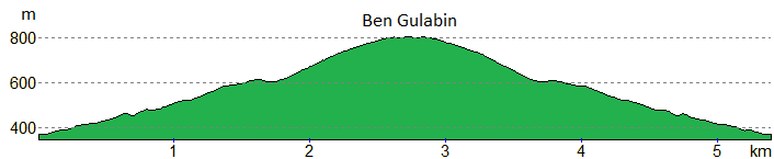
| Ascent | 450m (1470ft) | |||
| Distance | 5km (3m) | |||
| Time | 2:00hr | |||
| Start/finish | Spittal of Glenshee Grid Ref : NO114714 | |||
| Terrain |
| |||
| Nav |
| |||
| Effort |
| |||
| Scenery |
| |||


Standing above Spittal of Glenshee close to the A93, Ben Gulabin is a grass covered little lump of a hill. With an estate track climbing up most of the way up the Ben Gulabin's east-facing slopes, followed by a worn footpath travelling all the way to the summit, this is one of the easiest routes to a Corbett summit.
Extending the route to include nearby Càrn a' Ghèoidh in more remote surroundings makes for something a tad more challenging and interesting !
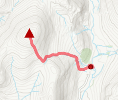
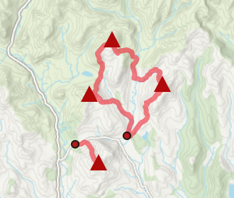
Show map
Route description
1. Getting to Glenshee

Route start by Spittal of Glenshee
The A93 connects Perth with Aberdeen, passing through Blairgowrie and Braemar in Deeside. Halfway between Blairgowrie and Braemar is Spittal of Glenshee on the junction between Glen Shee and Gleann Beag just before the road begins its climb to Glenshee Ski Centre.
By the roadside on the A93, around 1km north of Spittal of Glenshee, a sign by a gate indicates the start of the hillwalking route up Ben Gulabin.
Parking is limited to a couple of verge-side places by the gate (being careful not to block access).
2. Ben Gulabin

Glas Maol and Creag Leacach above the track
Through the gate, an estate track is followed northwards up a gentle incline.
After climbing around 150m, the track begins to turn north-west and crosses the Allt a' Charnaich (nearly dried up on my last visit after a dry early summer spell).
A further height gain of 50m or so, an old ruin is passed, before the track comes to a junction  , meeting with another rougher track, just below the bealach between Ben Gulabin and Creagan Bheithe.
This rough track heads south-west, crosses the Allt a' Charnaich once again, this tìme to its southern bank, then travels over damp grass-covered peaty ground uphill. Gradually becoming drier, grass is replaced by heather as the track gains height.

Glas Tulaichean from Ben Gulabin's summit
 , from where a boot-worn path takes over for the remaining short distance to the small cairn on Ben Gulabin's summit
  .
.Glas Tulaichean from Ben Gulabin's summit
3. Return or extend route

Looking across the bealach to Càrn Bhinnein and Càrn a' Gheoidh
The return is made by retracing the route downhill.
The route can easily be extended to Càrn a' Ghèoidh and other Glenshee Munros by following the estate track northwards from the bealach between Ben Gulabin and Creagan Bheithe. The track travels for much of the 4km to Càrn a' Ghèoidh with only a short section of pathless terrain just before the hill's summit.
If intending to hike this extended route, a bit of advance planning is recommended by perhaps dropping of a bike at the Glenshee Ski Centre or arranging other transport, in order to avoid a long walk back down the A93 to the foot of Ben Gulabin.
Route profile »
Maps and GPX downloads »


|
Download GPX of route |

|
Open route in OS Maps |
The map images above link to items on Amazon. A small commission is earned on any map purchased which helps fund the operating costs of this website.
Weather forecasts »
| Regional | MWIS - Southeast Highlands |
| Peak specific | Mountain Forecast.com Met Office YR.no |
| Seasonal | SAIS - Southern Cairngorms Midge forecast |
Alternative and nearby routes »
Glas Tulaichean and Càrn an Righ | |

|
Route up Glas Tulaichean and Càrn an Rìgh from Spittal of Glenshee. Estate tracks and clear paths ease the way to these two fine Munros. Peaks : 2 Munros
Ascent : 1170m (3840ft) Distance : 23km (14m) Time : 7:40hr |
East of Glenshee | |

|
Hillwalking route over the 4 Munros east of Glenshee, dominated by Glas Maol. High, vast, and pathless, with the option to add Creag nan Gabhar. Peaks : 4 Munros, option of 1 Corbett
Ascent : 910m (2990ft) Distance : 15km (9m) Time : 5:15hr |
Glenshee 9 Munros | |

|
Long high-level route linking the 9 Munros above Glenshee. With grassy slopes, this is one of the easier multi-Munro circuits, and a hill race. Peaks : 9 Munros
Ascent : 1690m (5540ft) Distance : 30km (19m) Time : 10:15hr |
Monamenach from Glen Isla | |
|
Hillwalking route up Monamenach from Auchavan in Glen Isla. Estate tracks make this Corbett one of the easiest to bag, with only 450m ascent and simple nav. Peaks : 1 Corbett
Ascent : 450m (1480ft) Distance : 5km (3m) Time : 2hr |
Glen Isla hills | |
|
Hillwalking route up Monamenach, Mount Blair, Badandun Hill and Duchary Hill - the Corbett and Fiona hills surrounding Glen Isla. Peaks : 1 Corbett, 3 Fionas
Ascent : 1610m (5280ft) Distance : 25km (16m) Time : 8:55hr |


