

Glen Isla hills
Hillwalking route up Monamenach, Mount Blair, Badandun Hill and Duchary Hill - the Corbett and Fiona hills surrounding Glen Isla.
Route outline
| Corbetts | ||||
| Fionas | ||||
| Ascent | 1610m (5280ft) | |||
| Distance | 25km (16m) | |||
| Time | 8:55hr | |||
| Start/finish | Folda, Glen Isla Grid Ref : NO187648 | |||
| Terrain |
| |||
| Nav |
| |||
| Effort |
| |||
| Scenery |
| |||


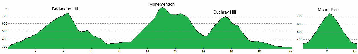
A delightful hill-running circuit above Glen Isla and along grassy crests, often following fence lines and walls to reach summits. Mount Blair sits close by but is better tackled on its own via the obvious track from the high pass between Glen Shee and Glen Isla.
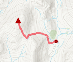
Show map

Route description
1. Getting to Glen Isla

By the bridge over the River Isla
North of Alyth and Blairgowrie, Glen Isla leads towards the southern Cairngorms and the Glenshee hills.
From Perth, follow the A93 north through Blairgowrie. Around 20km beyond the town, turn east onto the B951. After 5km, an unclassified road heads north up Glen Isla to reach a bridge over the River Isla.
On the eastern side of the bridge is a small parking area with space for a couple of cars, next to a Cateran Trail access point and information board. This is the start for the circuit.
2. Badandun Hill

Leaving the Cateran Trail, Badandun Hill ahead
From the parking area, there is right-of-way sign indicating the direction to Glen Prosen beginning by heading through a gate with deer-stalking information.
Through a gate, follow a fine estate track climbing gently uphill for just over 500m to a junction  . Taking the left fork, a grassy track is followed past forestry and around Badandun's southern spur 'The Knaps'.
A further junction  is met, this one marked with a post indicating the Cateran Trail heading east - take the left fork aiming north. The track rises onto Badandun Hill’s south-west shoulder, then turns northeast towards its summit.

Wall nearing Badandun's summit
 where a lonely trig point marks the top.
Wall nearing Badandun's summit
3. Monamenach

Track heading around Auchavan
From Badandun's summit, the track turns eastwards and this could be followed. However, for a much shorter descent, leave the track and head northwest initially over heather. The heather gives way for a descent down a lovely grassy slope to cross Fergus Burn and meet a track  .
.
The track is followed aside Fergus Burn downhill to meet with the forestry surrounding the buildings at Fergus. Before the forest  , leave the track and trace a faint path through rushes heading directly downhill.
Re-joining the track as it emerges out of the forestry, the River Isla is then crossed by a bridge. Meeting with the road in Glen Isla  , jog up it to its end at Auchavan
  .
.

At the pass below Monemenach, looking to Duchray Hill
 at about a height of 600m. Leave the track here and turn right onto a fainter ATV track that climbs more directly through heather. The heather becomes more stunted as old fence-posts appear near the top, leading to Monamenach’s summit cairn
  , a messy pile of stones and weathered old posts.
At the pass below Monemenach, looking to Duchray Hill
4. Duchray Hill (Mealna Letter)

Aside Duchray Hill's wall, looking back to Monemenach
From Monamenach, follow faint traces of path beside old posts aiming south-west. A flat peat-covered area is crossed before a slight rise gains the top of Craigenloch Hill  with Duchray Hill is view ahead.
Turning southwards and crossing more heather, ground begins to drop more steeply. Aiming south-east to avoid the steepest of the ground, descend through deep heather with hidden divots to gain more level grass-covered ground.

Mount Blair from the summit of Duchray Hill
 above Loch Beanie, a fence-line is crossed. Following the fence-line aside a wall, a faint path is traced travelling uphill on grass. The route ahead is straightforward with one little rocky notch gone under to gain Duchray Hill’s flat summit. The hill's top
  is marked by a cairn sitting close to a corner in the wall.
Mount Blair from the summit of Duchray Hill
5. Return to Glen Isla
Return for a short distance and get onto the eastern side of the wall. Aiming eastwards, beginning to lose height on grassy ground and meet with a fence line  aiming south-east. Follow the fence for around 500m or so to pass some steep ground on the left dropping eastwards.
Now onto the eastern side of the fence, drop down a delightful grass covered slope into Glen Beanie. As the ground begins to level further down, dense heather with more hidden divots needs negotiated. Beanie Burn is then crossed to reach a track  heading down the glen.
As the track nears the roadside in Glen Isla, a deer fence appears - take the first gate  which leads through woodland and by the houses at Dalvanie - the more obvious gate (the second gate) which is closer to the roadside, was locked when I was here.

Descending Duchary Hill down to Glen Beanie
Descending Duchary Hill down to Glen Beanie
6. Mount Blair
Continuing south-west from Duchray Hill and following the wall, Mount Blair could be included in a circuit with these hills. However, further down the hillside, recently planted forestry would need trotting over, and after up-and-down Mount Blair, there's around 3km on tarmac to return on. So Mount Blair is best hiked separately - the route up it couldn’t be more obvious !
The start point is 2km back along the road at the high pass between Glen Isla and Glenshee. Parking is available 300m west at the entrance to forestry tracks.

On Mount Blair's summit
 , an obvious track climbs steadily, runnable almost throughout. Around halfway up (at about a height of 550m), pass through a gate in a fence, then continue on a rougher track up the heather-clad hillside. After a further 200m of ascent, the summit
  is reached, marked by a trig point, cairn, and a mast. A circular wall surrounds a metal viewfinder (now rather faded), and inside a plaque commemorates local folk. The views from here are superb.
On Mount Blair's summit
Route profile »
Maps and GPX downloads »


The map images above link to items on Amazon. A small commission is earned on any map purchased which helps fund the operating costs of this website.
Weather forecasts »
| Regional | MWIS - Southeast Highlands |
| Peak specific | Mountain Forecast.com Met Office YR.no |
| Seasonal | SAIS - Southern Cairngorms Midge forecast |
Alternative and nearby routes »
Monamenach from Glen Isla | |
|
Hillwalking route up Monamenach from Auchavan in Glen Isla. Estate tracks make this Corbett one of the easiest to bag, with only 450m ascent and simple nav. Peaks : 1 Corbett
Ascent : 450m (1480ft) Distance : 5km (3m) Time : 2hr |
Driesh and Mayar | |

|
Hillwalking route up Driesh and Mayar above Glen Doll in the Angus Glens. Easy paths make these Munro twins ideal for a shorter day. Peaks : 2 Munros
Ascent : 900m (2950ft) Distance : 14km (9m) Time : 5hr |
East of Glenshee | |

|
Hillwalking route over the 4 Munros east of Glenshee, dominated by Glas Maol. High, vast, and pathless, with the option to add Creag nan Gabhar. Peaks : 4 Munros, option of 1 Corbett
Ascent : 910m (2990ft) Distance : 15km (9m) Time : 5:15hr |
Ben Gulabin from Spittal of Glenshee | |

|
Hillwalking route up Ben Gulabin from Spittal of Glenshee. A short, straightforward climb on estate tracks and a worn path all the way to the summit. Peaks : 1 Corbett, option to extend
Ascent : 450m (1480ft) Distance : 5km (3m) Time : 2hr |
West of Glenshee | |

|
Route over 3 Munros west of Glenshee. Càrn Aosda and The Cairnwell make an easy outing, extended with Càrn a’ Ghèoidh for a longer day. Peaks : 3 Munros, option of 1 Corbett
Ascent : 625m (2050ft) Distance : 11km (7m) Time : 3:50hr |


