

Creag Dhubh from Newtonmore
Hillwalking route up Creag Dhubh from Newtonmore through woodland and along its crest, with option to extend traverse down to Loch Uvie.
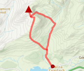
Route outline
| Fionas | ||||
| Ascent | 510m (1670ft) | |||
| Distance | 8km (5m) | |||
| Time | 2:50hr | |||
| Start/finish | Biallid Farm, Newtonmore Grid Ref : NN705985 | |||
| Terrain |
| |||
| Nav |
| |||
| Effort |
| |||
| Scenery |
| |||


A delightful hike beginning in woodland, ascending via Creag Dhubh's crest to its summit, offering fine views over Strathspey, Laggan, and Lochaber. If transport can be arranged, the route can be extended to traverse the full length of the hill above its dramatic southern face - home to schist cliffs that are famed for rock climbing - before descending to Loch Uvie.
Show map
Route description
1. Getting to Biallid Farm

Roadside by Biallid Farm near Newtonmore
From the centre of Newtonmore, the A86 travels south-west out of the village. As the road leave the village, it crosses the River Calder and the route begins from the west side of the bridge. Parking is a bit tricky around here, with only a space or two on the east side of the bridge by the entrance to Banchor Cemetery. There are plenty of places to park in Newtonmore.
To traverse the hill, the route ends (or begins) from Loch Uvie below the southern face of Creag Dhubh - the schist cliffs on which are famed for rock climbing. Parking is available in a couple of lay-bys overlooking the loch.
2. Creag Dhubh

In the woodlands below Creag Dhubh
Begin by following the estate road between fields, heading towards Biallid Farm. Just before reaching the farm buildings, take the second turning on the right. This leads past a few houses and to a junction. Continue straight ahead over a cattle grid, then turn left onto a track that enters a field - on all of my visits, this section required ducking under an electric fence.
Continue on the track as it heads uphill towards a gate. Through the gate, the track is followed as it enters woodland, bends to the right, then to the left and again to the right. On this second right bend  , to left is evidence of ATV tracks, but directly ahead and partially hidden in the undergrowth, a faint path can be found. If a small hut is reached while on the track - you've gone too far !
Take this faint woodland path as it climbs gently, then turns westward, winding through increasingly delightful woodland. The gradient soon steepens  , with a few "granny-stoppers" (small rocky steps) to clamber over, before the path eventually exits the trees.
Emerging onto a heather-clad hillside, the path continues uphill, cutting through exposed peat in places. Partway up this steeper slope, look for a fork  in the track to the left - take this turning as it swings southwest beneath a minor summit.
The route now follows the broad shoulder of Creag Dhubh, and views begin to open up ahead and to the west. After a short dip, the path makes a more direct line towards the summit, about 1.5km ahead.In places it crosses some marshy ground, where it may become faint at times, but always reappears clearly further on.

Creag Dhubh's crest
 , with a smaller cairn just beyond. The views in all directions are superb.
Creag Dhubh's crest
3. Alternative from Lochain Uvie

Beginning a descent back to Newtonmore
The most practical option is to retrace your steps back to Newtonmore, perhaps including a short detour to the cairn on An Tor  , which offers excellent views.
If transport is available, a rewarding alternative descent is to traverse Creag Dhubh's south-western shoulder, ending at Loch Uvie…
From the summit of Creag Dhubh, descend to the lower of the two cairns, then follow a fairly well-defined path heading southwest over a mix of terrain. After crossing a fence-line and descending further, the path skirts above the cliffs overlooking Loch Uvie, meeting a short section of stone wall on the way.

Evening run up Creag Dhubh from Loch Uvie
 before descending to a gate
  by the roadside, followed by a brief walk leading to the lay-bys above Loch Uvie.
Evening run up Creag Dhubh from Loch Uvie
4. Creag Dhubh Hill Race

Leader returning to games field
Held as part of Newtonmore's Highland Games on the first Saturday in August, the Creag Dhubh Hill Race is a short but intense up-and-down challenge.
The race begins with a lap around the games field, before heading out across nearby farmland - often filled with thistles and nettles! A river crossing at the River Calder leads to Biallid Farm, where it joins the same route described above. Local runners often know a few brief time-saving shortcuts.
The course passes the cairn on An Tor with a brief detour, then follows the return path, concluding with a final sprint around the games track.
Route profile »

Maps and GPX downloads »


|
Download GPX of route |

|
Open route in OS Maps |
The map images above link to items on Amazon. A small commission is earned on any map purchased which helps fund the operating costs of this website.
Weather forecasts »
| Regional | MWIS - Cairngorms and Monadhliath |
| Peak specific | Mountain Forecast.com Met Office YR.no |
| Seasonal | SAIS - Creag Meagaidh Midge forecast |
Alternative and nearby routes »
Càrn Dearg in the Monadhliath | |

|
Circular hillwalking route up Càrn Dearg in the Monadh Liath from Glen Banchor, with the option of adding Creag Liath on the way. Peaks : 1 Munro, option of 1 Fiona
Ascent : 770m (2530ft) Distance : 18km (11m) Time : 5:50hr |
Monadhliath Munros | |

|
Linear hillwalking route over all four Monadh Liath Munros: A’ Chailleach, Càrn Sgulain, Càrn Dearg and Geal Chàrn, with demanding navigation. Peaks : 4 Munros
Ascent : 1420m (4660ft) Distance : 30km (19m) Time : 9:50hr |
Eastern Monadhliath Munros | |

|
Hillwalking route from Glen Banchor up A’ Chailleach and Càrn Sgulain, the most easterly Monadh Liath Munros, with gentle slopes and tricky navigation. Peaks : 2 Munros
Ascent : 750m (2460ft) Distance : 14km (9m) Time : 4:45hr |
Càrn an Fhreiceadain from Kingussie | |

|
Hillwalking route up Càrn an Fhreiceadain from Kingussie. Estate tracks make for a straightforward circular over the broad summit above the town. Peaks : 1 Corbett
Ascent : 680m (2230ft) Distance : 16km (10m) Time : 5hr |
Geal Chàrn from Spey Dam | |
|
Hillwalking route up Geal Chàrn at the western end of the Monadh Liath. Gentle slopes hide odd landforms and interest off the direct line. Peaks : 1 Corbett
Ascent : 740m (2430ft) Distance : 15km (9m) Time : 4:45hr |


