
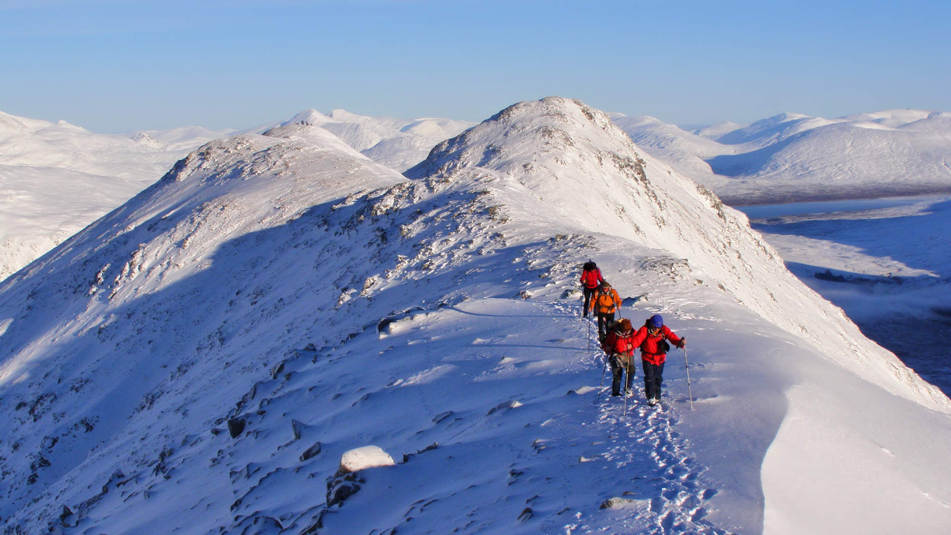
Shepherds of Etive
Classic Glencoe route on Buachaille Etive Mòr and Etive Beag, the Shepherds of Etive, with rugged ridges and easy scrambling between Munros.
Route outline
| Munros | ||||
| Ascent | 1875m (6150ft) | |||
| Distance | 19km (12m) | |||
| Time | 8:00hr | |||
| Start/finish | Altnafeadh, Glencoe Grid Ref : NN221563 | |||
| Terrain |
| |||
| Nav |
| |||
| Effort |
| |||
| Scenery |
| |||


Etive Mòr and Etive Beag are rugged mountains with intimidating profiles, particularly when viewed from Glencoe. Coire na Tulaich and Coire Altruim on Etive Mòr have some loose ground and rough slabs that can catch out hillwalkers. Once onto the mountain crests, routes are fairly obvious on worn paths following ridge-lines.
This route can easily be cut into two days, with Etive Beag on one and Etive Mòr on the other. If intending to do this, there is a shorter and easier route up Etive Beag starting from a few miles to the west of Altnafeadh and heading up the other side of the mountain, details are here.
Show map

Route description
1. Getting to Altnafeadh in Glencoe

Etive Beag from the River Coupall
The main parking area for the Etives is by the farm buildings of Altnafeadh on the A82, 4km west of Kingshouse Hotel.
This can be very busy in summer and at weekends, therefore additional parking is available 1km further west of Altnafeadh.
If heading up Curved Ridge, then limited roadside parking is possible 2km east of Altnafeadh on a corner.
2. Etive Beag - Stob Coire Raineach

Etive Beag's Stob Coire Raineach from the south
From the main car-park at Altnafeadh, walk westwards along the road to the other car-park. A right-of-way sign-post points the way down the Làirig Gartain, from where a path starts.
Get on this path, which can be fairly sodden and crosses some occasional bog. Follow it along the northern bank of the River Coupall for 2km to where a burn flows down from the Màm Buidhe pass on Etive Beag  .
.
Turn right and follow a path heading up the east bank of this burn. As height is gained, the path becomes fainter, but it can be traced up to the bealach  between Etive Beag's two Munro summits.
Turn right (north-east) and follow an obvious and worn path through scree and small boulders to Stob Coire Raineach's summit  . Excellent views - tìme for a stop for a bit to take them in !
3. Etive Beag - Stob Dubh

Etive Beag's Stob Dubh from Stob Coire Raineach
From Stob Coire Raineach's summit return to the bealach .
On a very obvious path, start climbing south-west up grassy and occasional sections of loose gravel. The ground levels out at c900m, from where it's a straightforward walk taking in the fine views all around.
The base of the last climb up Stob Dubh is reached and the ground narrows to a scrambly crest. No real difficulties are encountered, but there is a real airy feel to this section of the route.
Upon reaching the summit cairn  , you'll find the views down Glen Etive are blocked by a minor top, so continue south-west for a few metres over some boulders to a smaller cairn for amazing views down Loch Etive and beyond.
4. Etive Mòr - Stob na Broige

Stob na Broige from Stob na Doire
Return to the Màm Buidhe bealach , then head back down to the Làirig Gartain following the burn you came up.
Upon reaching the glen floor, cross the Làirig Gartain path and drop down over tussocky ground to the River Coupall. Even after rain, I've never found this river difficult to cross !
Once across, directly ahead is the peak of Stob Coire Altruim with a burn coming down from the coire to your left.
On the west (right) side of this burn, a well worn path climbs up into the coire. Follow this path up. It's loose in bits and, particularly in wet conditions or in snow, will require some care to clamber over rocks. There is one little nasty bit  and keeping into the groove on the right-hand-side of this is much safer than the exposed rocks on the left-hand-side.
Up onto the ridge on a flat area  west of the bealach that separates Stob Coire Altruim from Stob na Doire, a faint bypass path contours around the south side of Stob Coire Altruim's summit.
Alternatively, on an obvious path, you can head up to the summit cairn on Stob Coire Altruim then continue south-west along the crest.
Both of these routes converge and continue along the crest.
One short last pull up over some gravel and stone will get you on Stob na Broige's summit cairn  , where some beautiful views await.
5. Etive Mòr - Stob Dearg

Heading north along Etive Mòr to Stob Dearg
Head back to the flat area west of the bealach beyond Stob Coire Altruim, then continue on a worn path over a bump to drop to the the bealach.
Aim north-east directly uphill along a path on the crest. Initially the ground is grass covered, then onto scree and rock higher up. A small cairn sits on Stob na Doire  .
.
Turn north and lose some height by dropping down on more loose gravel and over some boulders and rock. Further down the crest widens and a worn path is followed over undulating grass covered ground to the small cairn sitting above Coire na Tulaich  . This cairn is marking the route down, but there is still one more peak to bag - Stob Dearg, the highest Etive peak.
The terrain changes dramatically from grass to pink loose rock and scree. From the top of Coire na Tulaich, a very obvious path zig-zags up onto the crest of Stob Dearg and this is then followed to the summit  .
.
Once here, you can glow in the knowledge that you've left the best view-point to the end of the day. A vast panorama is enjoyed from this summit, with Rannoch Moor below and Schiehallion pointing up far in the distance.
6. Return to Glencoe

Looking down Coire na Tulaich
Return to the cairn above Coire na Tulaich .
In winter the descent from here may be corniced over and ice descending techniques will be called upon. Otherwise, although the descent may look difficult, it's actually pretty straightforward.
A fairly easy scramble is required down the initial drop into the gully, then keeping to the left side (west) of the burn, from where scree makes for a fast descent.
A rough path is picked up and followed down into Coire na Tulaich and out to the hut at Lagangarbh, from where a short walk will return you to your car.
Route profile »

Maps and GPX downloads »


|
Download GPX of route |

|
Open route in OS Maps |
The map images above link to items on Amazon. A small commission is earned on any map purchased which helps fund the operating costs of this website.
Weather forecasts »
| Regional | MWIS - Western Highlands |
| Peak specific | Mountain Forecast.com Met Office YR.no |
| Seasonal | SAIS - Glencoe Midge forecast |
Alternative and nearby routes »
Buachaille Etive Beag from Glencoe | |

|
Hillwalking route up Buachaille Etive Beag from Glencoe, with ascents of Stob Coire Raineach and Stob Dubh, less intimidating via the west side. Peaks : 2 Munros
Ascent : 940m (3080ft) Distance : 8km (5m) Time : 3:40hr |
Aonach Eagach traverse | |

|
Aonach Eagach traverse in Glencoe is a committing scramble over Meall Dearg and Sgòrr nam Fiannaidh with exposed rocky sections and superb views. Peaks : 2 Munros
Ascent : 1200m (3940ft) Distance : 8km (5m) Time : 6hr |
Beinn a' Chrùlaiste from Glencoe | |

|
Hillwalking route up Beinn a' Chrùlaiste from Glencoe and Kingshouse, a rough path ascent with outstanding views over Rannoch Moor and Etive Mòr. Peaks : 1 Corbett
Ascent : 700m (2300ft) Distance : 11km (7m) Time : 4hr |
Bidean nam Bian and Stob Coire Sgreamhach | |

|
Hillwalking route up Bidean nam Bian and Stob Coire Sgreamhach from Glencoe, finishing via a descent through the dramatic ‘Lost Valley’. Peaks : 2 Munros
Ascent : 1300m (4270ft) Distance : 10km (6m) Time : 4:30hr |
Black Mount mountains from Glen Etive | |

|
Hillwalking route from Glen Etive to Beinn Mhic Chasgaig, Creise and Meall a’ Bhùiridh. A tough there-and-back linking a Corbett with two Black Mount Munros. Peaks : 2 Munros
Ascent : 1500m (4920ft) Distance : 15km (9m) Time : 6:15hr |


