

Aonach Eagach traverse
Aonach Eagach traverse in Glencoe is a committing scramble over Meall Dearg and Sgòrr nam Fiannaidh with exposed rocky sections and superb views.
Route outline
| Munros | ||||
| Ascent | 1200m (3930ft) | |||
| Distance | 8km (5m) | |||
| Time | 6:00hr | |||
| Start | Three Sister's car-park, Glencoe Grid Ref : NN173568 | |||
| Finish | By Loch Achtriochtan Grid Ref : NN147571 | |||
| Terrain |
| |||
| Nav |
| |||
| Effort |
| |||
| Scenery |
| |||


The Aonach Eagach which appropriately means 'notched ridge', travels along the northern side of Glencoe and is probably the most famous ridge in the country. Viewed from Glencoe below, the Aonach Eagach ridge appears as a narrow crest with a series of small towers. It is only once onto the crest that the scale and size of the ridge of becomes apparent.
This is a commiting route and there are no 'escape' routes from the ridge between Meall Dearg and Stob Coire Lèith. To attempt this route, you'll need a decent head for heights and be confident on at least Grade 1 rock-scrambling ground. You may find comfort in the security of a rope on some sections or prefer the help of a guide (see below).
Show map

Route description
1. Getting to Glencoe

Looking down to the Aonach Eagach car-aprk in Glencoe
On the A82 in the heart of Glencoe there are two large car-parks looking over to the impressive buttresses of the Three Sisters of Glencoe. Just up the road from these car-parks and on the other side of the road there is a rough smaller car-park with room for around 5 or 6 vehicles - the route starts from here.
This route finishes down the glen, just east of Loch Achtriochtan - a path tracing the line of the old road connects the start and end points.
2. Am Bodach

On Am Bodach
From the rough car-park, aim uphill on an obvious path climbing steeply aimming eastwards. The path turns northwards and meets some old iron fence-posts, and then climbs another 200m of ascent where there are a couple of options  .
.
The route from this point that most people take heads directly uphill north-westwards, following the path, rough and loose in places with a few hands-out-of-pockets moves, ending up on the summit of Am Bodach  .
.
Alternatively, a better route follows faint traces of an older path that initially heads right under a buttress of rock to pick up the banks of the Allt Ruigh. Crossing this burn a couple of times (a good place to top up water-bottles), a final grassy ascent leads onto the crest  between Sròn Ghairbh and Am Bodach for a superb view along the Aonach Eagach towards Meall Dearg. A rough ascent up bouldery ground gains the summit of Am Bodach .
3. Meall Dearg

Aonach Eagach ridge leading westwards from Meall Dearg
After taking in the views from Am Bodach (stunning over the Mamores to Ben Nevis), the next bit is slightly tricky and sets the scene for the the traverse of the Aonach Eagach.
From Am Bodach's summit follow the path north-west and it comes to a sudden and sharp drop. The drop is around 20m or so and looks a lot more difficult to climb down than it actually is, though it can be slippy if wet. Keeping to the north side of the crest, start to descend, the route quickly switches back left (south), and drops in a series of big steps to the safety of the path below. You'll know if you're on the right route if you can see the fence-post and crampon-marks !
This awkward bit done, there's some easy rocky ground to reach the bealach between Am Bodach and the Aonach Eagach's east Munro, Meall Dearg. Continue westwards, passing occasional fence-posts and The Chancellor - a huge drop on the south side of the ridge - and reach the Munro summit of Meall Dearg  .
.
4. Crazy Pinnacles

On the Crazy Pinnacles (pic courtesy Al Halewood)
From Meall Dearg's summit, continue west on the obvious and well-worn path downhill following the crest of the ridge.
A narrow gap is followed by a climb of 15m up a chimney (much easier than it looks), then continue along the distinct path on ridge's crest, some short sections of easy scrambling and rough moves on the way.
Eventually the crux of the ridge, the 'Crazy Pinnacles'  , is reached with drops on both sides. A path descending westwards on the north side of the ridge looks like a bypass path - it's not, it's a dead end ! Keeping to the ridge and on its north side manouvre yourself by hugging the two pinnacles - it looks daunting, but again it's actually easier than it looks - there are good handholds to be found.
You'll now be confronted with a short steep exposed rise, there is no option but to head straight up it - again it's easier than it looks !
(pic courtesy Al Halewood)
5. Sgòrr nam Fiannaidh

Ridge done, heading up to Stob a'Choire Leith
That's the real difficulties over with ! Continue along the ridge tackling a few more easy rock-scrambling bits on the way and reach Stob Coire Lèith  .
.
The path continues along the ridge over easy ground to a bealach  , then goes up some patches of scree and boulders to the cairn on Sgòrr nam Fiannaidh
  . Superb views in all directions, particularly back along the ridge just done.
6. Return to Glencoe

Descending screes down to Glencoe
There are various options for descent, including a direct route down to the Clachaig (probably best avoided as considered dangerous) or the Pap of Glencoe path which will see you end up around 2km north of the Clachaig.
My personal choice begins with a return to the bealach , then descending initially on steep loose scree, head directly downhill. Traces of path can be picked up on the scree with the route turning south-west with some sections of good running screes - great fun bounding down.
Lower down the screes are replaced by grass and a couple of paths can be picked up to descend to the A82 - one follows the Allt an t-Sidhein to the western end of Loch Achtriochtan, the other aims direct for the long lay-by to the east of Loch Achtriochtan.
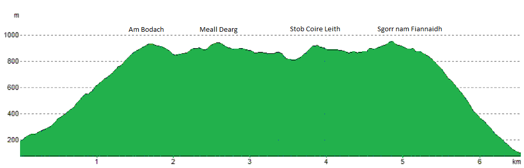
Route profile »
Maps and GPX downloads »




The map images above link to items on Amazon. A small commission is earned on any map purchased which helps fund the operating costs of this website.
Weather forecasts »
| Regional | MWIS - Western Highlands |
| Peak specific | Mountain Forecast.com Met Office YR.no |
| Seasonal | SAIS - Glencoe Midge forecast |
Alternative and nearby routes »
Garbh Bheinn from Loch Leven | |

|
Hillwalking route up Garbh Bheinn from Loch Leven, following wet tracks then rough slopes and boulderfield to reach the Corbett summit. Peaks : 1 Corbett
Ascent : 840m (2760ft) Distance : 6km (4m) Time : 3hr |
Bidean nam Bian and Stob Coire Sgreamhach | |

|
Hillwalking route up Bidean nam Bian and Stob Coire Sgreamhach from Glencoe, finishing via a descent through the dramatic ‘Lost Valley’. Peaks : 2 Munros
Ascent : 1300m (4270ft) Distance : 10km (6m) Time : 4:30hr |
Bidean nam Bian via the Zig-Zags | |

|
Rock-scrambling up Bidean nam Bian via Geàrr Aonach and the Zig-Zags. A superb summer route with some exposed Grade 1-2 pitches. Peaks : 2 Munros
Ascent : 1325m (4350ft) Distance : 10km (6m) Time : 5hr |
Beinn a' Chrùlaiste from Glencoe | |

|
Hillwalking route up Beinn a' Chrùlaiste from Glencoe and Kingshouse, a rough path ascent with outstanding views over Rannoch Moor and Etive Mòr. Peaks : 1 Corbett
Ascent : 700m (2300ft) Distance : 11km (7m) Time : 4hr |
Shepherds of Etive | |

|
Classic Glencoe route on Buachaille Etive Mòr and Etive Beag, the Shepherds of Etive, with rugged ridges and easy scrambling between Munros. Peaks : 4 Munros
Ascent : 1875m (6150ft) Distance : 19km (12m) Time : 8hr |


