
Ring of Steall hiking route
Hillwalking route on the Ring of Steall, bagging 4 Munros of Sgùrr a' Mhàim, Am Bodach, An Gearanach and Stob Coire a' Chairn with some enjoyable scrambling.
Route outline
| Munros | ||||
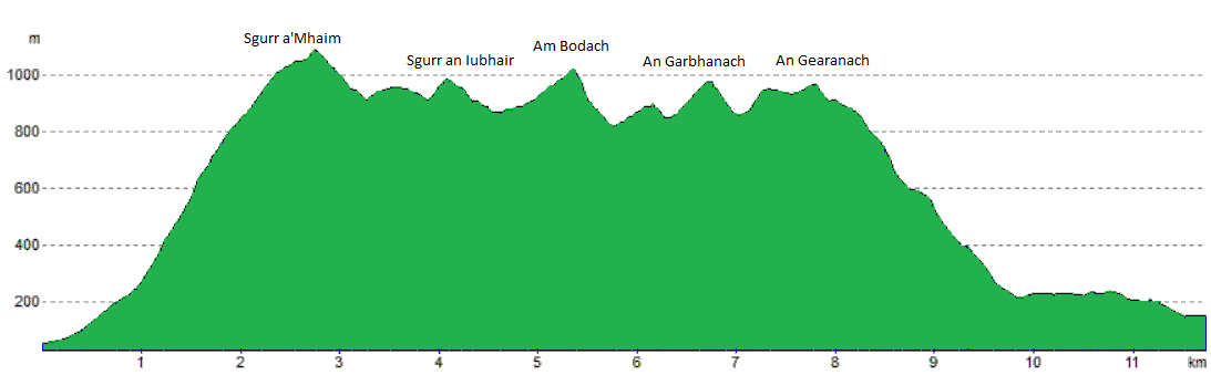
| Ascent | 1750m (5740ft) | |||
| Distance | 15km (9m) | |||
| Time | 6:45hr* | |||
| Start/finish | Achriabhach, Glen Nevis Grid Ref : NN142684 | |||
| Terrain |
| |||
| Nav |
| |||
| Effort |
| |||
| Scenery |
| |||


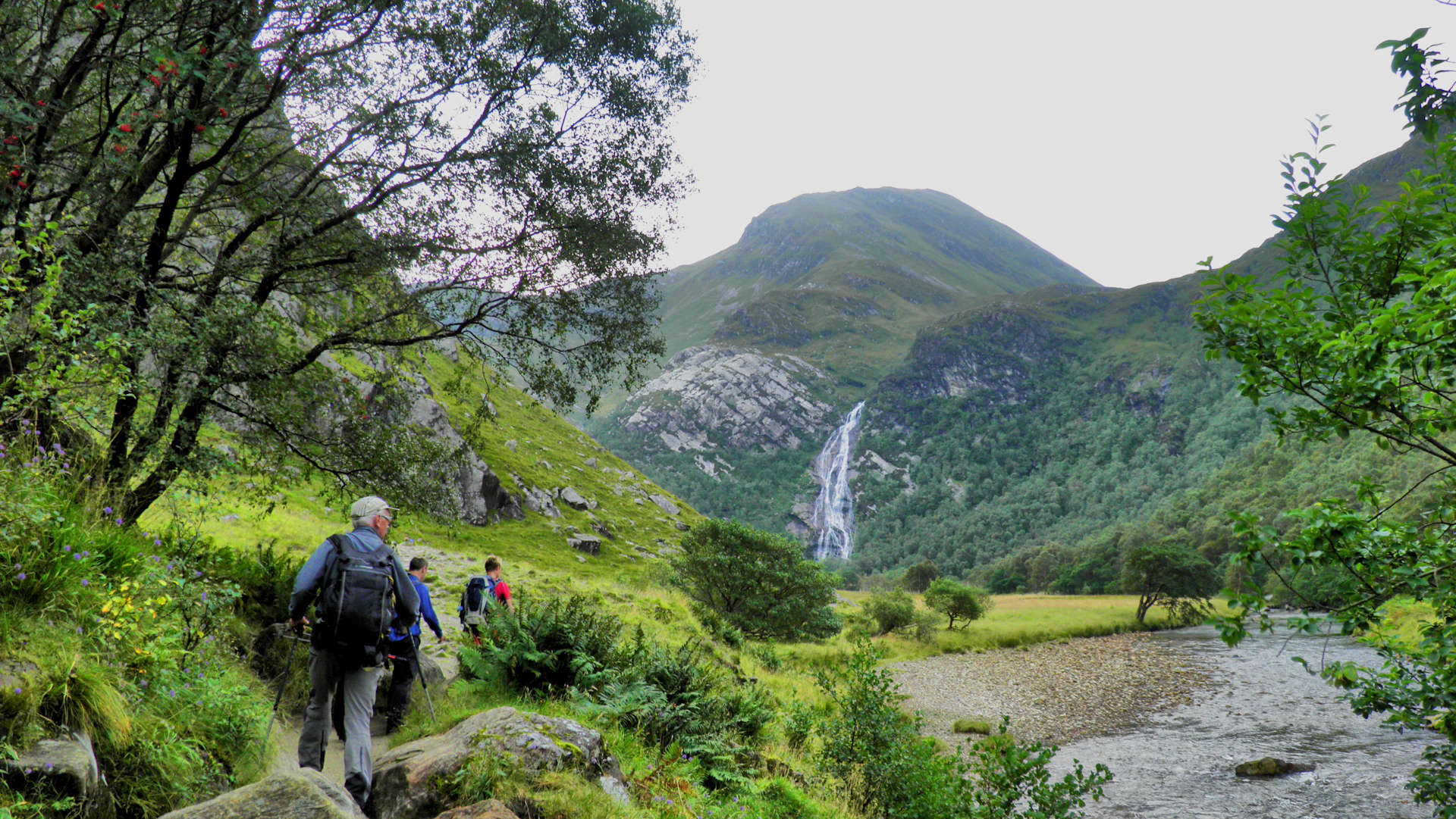
Starting and finishing in Glen Nevis, the route explores some of the finest terrain in the range, with grassy crests and narrow rocky ridges connecting the summits. The route also passes the spectacular Falls of Steall, Scotland’s second-highest waterfall.
Some enjoyable and fairly easy summer rock-scrambling is encountered on the Devil’s Ridge south of Sgùrr a’ Mhàim and on the southern flank of An Garbhanach.
Route map

Route description
1. Getting to Achriabhach

Sgùrr a' Mhàim and the start from the Lower Falls
In Fort William, just north of the Lochaber Leisure Centre, there is a small roundabout.
Take the turning into Glen Nevis and head up here for 7km to the Lower Falls car-park just beyond the farm buildings of Achriabhach and before the bridges over the Water of Nevis (there is a charge to park here).
2. Sgùrr a' Mhàim

Looking back down Glen Nevis on the way up Sgurr a' Mhaim
From the car-park, walk towards the bridges over the Water of Nevis and cross the first of these. Immediately thereafter and before the second bridge, you'll see a gate on your right, with a stile to cross. Over this, follow a track then rough but obvious path south-east.
The path begins to climb up gentle slopes and after around 1km, there is a split in the path  - take the left (east) fork.
Now climbing more steeply, the path goes through a gate in a deer-fence and strikes up Sgùrr a' Mhàim's north-western shoulder. The path is rough and loose. At around the 900m contour, the summit screes are met, with the path zig-zagging a way through and onto Sgùrr a' Mhàim's summit crest, where the ground levels and the large untidy summit cairn  is reached.
3. Over the Devil's Ridge to Sgùrr Iubhair

Approaching the Devil's Ridge from the south, Sgùrr a' Mhàim behind
Leave Sgùrr a' Mhàim's summit behind and strike downhill on a rough and loose path on bouldery ground. As height is lost, the terrain becomes grass-covered and easier.
A small col (Bealach a' Chip)  is reached with a rocky slab the other side - keeping slightly to the right (west), a ledge with good holds can be traced to ascend this obstacle.
The grassy crest narrows with a worn path leading southwards. The crux of the Devil's Ridge is reached  - it's much easier than it looks (outwith winter conditions). Keeping to the right (west) with the big boulders on your left, a rough, steep and loose route can be climbed down, then back out the other side.
A worn path leads over Stob Choire a'Mhail and over boulders then loose scree up to Sgùrr Iubhair's summit  .
.
4. Am Bodach

Am Bodach from Stob Coire a' Chairn
Sgùrr Iubhair is a significant summit and was promoted to Munro status in 1984, only to be demoted back to a Munro Top in 1997 !
A path heads south-east from Sgùrr Iubhair's summit. Though obvious and easy to walk on, this path seems to be quite tricky to run on - the rocks just seem to be awkwardly spaced.
The path reaches the bealach then makes a direct ascent up Am Bodach  , its rougher higher up but without any difficulties being encountered.
5. Stob Coire a' Chairn

Stob Coire a' Chairn from An Gearanach
Getting off Am Bodach to continue a traverse of the Mamores can be slightly rough and some people may find the next section challenging !
Aim north-east down steep and very loose ground on bits of worn path. Be careful with your footing as you pick your way down on the gravel using rocks as 'islands of safety'. Some small bits of easy scrambling are encountered, then some scree boulders as the bealach above Coire a' Bhodaich is approached.
Now onto grassy ground, follow the path up over one bump (marked 909m)  , then up to the bouldery summit of Stob Coire a' Chairn
  . Although a fine vantage point, this summit feels more part of An Gearanach than a Munro summit in its own right.
6. An Gearanach

An Gearanach from Stob Coire a' Chairn
A worn path heads initially north from the summit of Stob Coire a' Chairn. Zig-zagging through some scree, it drops just over 100m to the bealach  below the steep climb of An Garbhanach.
Climb up the path on the right (east) side of the crest, then cross over to the left (west), then back over to the right (east), before clambering up onto the crest - the route is pretty obvious. Some sustained but straightforward scrambling lies ahead up to and over An Garbhanach as the route sticks to the crest - there are slightly exposed bypass paths on the east side of the crest.
Passing the top of An Garbhanach (no cairn), there's a slight drop, and An Gearanach  lies ahead - just a walk over a grass covered crest reaches the summit. The small cairn on An Gearanach's summit is an excellent place to stop and take in the views.
7. Return to Glen Nevis

The wire bridge over Water of Nevis
A stalker's path leads north from An Gearanach's summit. It twists and turns taking the easiest line avoiding rock buttresses. Lower down some landslips have taken sections of the path away, so a bit of care is needed.
The path reaches the Water of Nevis, it can either be crossed direct  - some stepping stones can be seen if water level isn't too high. Or a very wet and rough path can be taken that leads westwards to under the spectacular Falls of Steall (tricky to cross in spate) to reach a wire bridge over the Water of Nevis on which a bit of fun can be had crossing it.
Get onto the path which leads down the north side of the Nevis Gorge (take care here).
The road-end is reached, from where a 3km walk or jog downhill will take you back to Achriabhach.
Maps and GPX downloads »


Route profile »
Weather forecasts »
| Regional | MWIS - Western Highlands |
| Peak specific | Mountain Forecast.com Met Office YR.no |
| Seasonal | SAIS - Lochaber Midge forecast |
Alternative and nearby routes »
Western Mamores hiking route | |
|
Hillwalking route up Mullach nan Coirean and Stob Bàn, a western Mamores horseshoe with rough ground and two fine Munro summits. Peaks : 2 Munros
Ascent : 1200m (3940ft) Distance : 12km (7m) Time : 5hr* | |
Eastern Mamores | |
|
Hillwalking route from Kinlochleven around the eastern Mamores, climbing Binnein Mòr and other Munros on fine stalkers paths and rough ridges. Peaks : 4 Munros, plus option of 1 Corbett
Ascent : 2000m (6560ft) Distance : 18km (11m) Time : 8hr* | |
Màm na Gualainn from the West Highland Way | |
|
Hillwalking route up Màm na Gualainn from the West Highland Way, climbing from a quiet glen over heather slopes to its grassy summit. Peaks : 1 Corbett
Ascent : 755m (2480ft) Distance : 11km (7m) Time : 4hr* | |
Mamores range of Munros | |
|
Hillwalking route traversing all 10 Munros of the Mamores, a classic outing linking ridges and summits between Glen Nevis and Glencoe. Peaks : 10 Munros
Ascent : 3400m (11150ft) Distance : 34km (21m) Time : 14hr* | |
Ben Nevis via the Mountain Track | |
|
Hillwalking route up Ben Nevis via the Mountain Track, a zig-zagging path to the UK’s highest summit. Straightforward but never underestimate weather ! Peaks : 1 Munro
Ascent : 1340m (4400ft) Distance : 16km (10m) Time : 6:15hr* | |
* Times shown are estimates – see timing notes on the disclaimer page for more information.

