

Stac Pollaidh from Loch Lurgainn
Hillwalking route up Stac Pollaidh from Loch Lurgainn. A short, popular circuit on good paths, with scrambling needed to reach the true top.
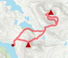
Route outline
| Fionas | ||||
| Ascent | 575m (1880ft) | |||
| Distance | 5km (3m) | |||
| Time | 2:00hr | |||
| Start/finish | Loch Lurgainn, Inverpolly Grid Ref : NC108096 | |||
| Terrain |
| |||
| Nav |
| |||
| Effort |
| |||
| Scenery |
| |||


Stac Pollaidh is a unique and very distinctive little mountain, standing isolated in the north-west highlands. This, combined with its proximity to the roadside, has made it a very popular hill during tourist seasons and a well-constructed path has been built to cope with the errosion.
The path climbs around the base of Stac Pollaidh and up its northern side onto its crest. Traversing the ridge is very enjoyable in fine conditions, though to reach the summit requires negotiating a 'bad step' which calls for fine rock-scrambling skills.
Show map
Route description
1. Getting to Loch Lurgainn

Gate below Stac Pollaidh
North of Ullapool, the A835 continues north-east through Coigach to Ledmore Junction. Around halfway between Ullapool and Ledmore Junction are a couple houses that make Drumrunie, immediately south of which a narrow unclassified road heads westwards towards Achiltibuie.
Turning onto this road, head for around 3km to Loch Lurgainn and then a further 4km above its eastern and northern shores.
You'll come to the large car-park below Stac Pollaidh with welcoming sign boards. As of 2025, there is a charge to park - £6 for cars, £8 for motorhomes and campervans.
2. Stac Pollaidh

At the bealach by Stac Pollaidh's eastern top
From the large car-park, cross the road, head through a gate and begin uphill hiking through a wood on a well constructed footpath.
After climbing around 40m, the woodland is left behind and the path comes to a junction  - take the right (east) fork. Shortly after the junction, the path comes to a gate in a deer-fence and once through, its onto open hillside following the well-constructed path.
The path meanders and climbs around the eastern base of Stac Pollaidh and as it turns north-west, comes to a split  - take the obvious, but less well-constructed path on the left aiming due-west and climbing steeply uphill.
The path climbs and zig-zags up loose ground to a bealach  by Stac pollaidh's eastern summit (spot height of 551m).
The eastern summit is a fine vantage point and a good place to stop for a breather.
Stac Pollaidh's highest point is on the opposite end of the ridge and between it and the eastern summit is a fair bit of rugged ground to contend with. There is an obvious boot worn path traversing the route, keeping below the crest in bits and switching between the north and south side of the ridge. Some of this is exposed, but there's nothing of any difficulty if keeping to the path. There are alternatives should you fancy a little fun scrambling.
That is until you reach the gap immediately below the highest and most westerly summit - there is a nasty little bad step to negotiate ! If you don't fancy scrambling up the step, then just before reaching it, there is a detour to another, slightly lower summit on which most people will be happy to call it a day.
I'd guess that in the dry, the bad step is an exposed scramble up a little tower verging on Grade 3 - most competent rock-scramblers should be able to climb up and down it without the use of a rope. A down-climb of the step will be needed on the return.

The awkward step on Stac Pollaidh
 .
.The awkward step on Stac Pollaidh
3. Return to Loch Lurgainn

Cul Beag and Stac Pollaidh's centre peak from the western peak
To return you could simply re-trace your route up.
Alternatively, a circular route can be made. To do this, return along the ridge to around halfway and get onto the north side of the crest. Head directly down the fall-line on scree to join a path by the remains of a fence. Turn left (north-west) and follow the path until it joins the main constructed footpath  at around c500m. Aim west on this constructed footpath and follow it around the western base of Stac Pollaidh and back to the car-park.
Route profile »

Maps and GPX downloads »


|
Download GPX of route |

|
Open route in OS Maps |
The map images above link to items on Amazon. A small commission is earned on any map purchased which helps fund the operating costs of this website.
Weather forecasts »
| Regional | MWIS - Northwest Highlands |
| Peak specific | Mountain Forecast.com Met Office YR.no |
| Seasonal | Midge forecast |
Alternative and nearby routes »
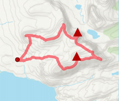
Cul Beag and Cul Mòr | |
|
Hillwalking route up Cul Beag and Cul Mòr from Loch Lurgainn. A rough outing through Inverpolly’s lochans and forests linking the two summits. Peaks : 2 Corbetts
Ascent : 1650m (5410ft) Distance : 16km (10m) Time : 6:25hr |
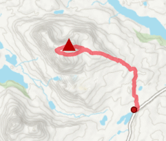
Cul Mòr from Knockan Crag | |
|
Hillwalking route to Cul Mòr from Knockan Crag. A short climb following a good stalker's path most of the way to the rocky summit. Peaks : 1 Corbett
Ascent : 720m (2360ft) Distance : 11km (7m) Time : 4hr |
Ben More Coigach and Sgùrr an Fhidhleir | |
|
From Achiltibuie, a circular route explores Ben More Coigach, Sgùrr an Fhidhleir and nearby tops, with superb views over Coigach and the Summer Isles. Peaks : 2 Fionas
Ascent : 1035m (3400ft) Distance : 15km (9m) Time : 5:30hr |
Suilven circuit | |
|
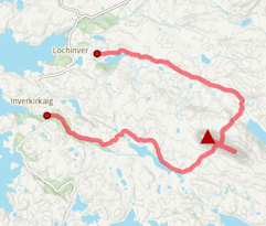
Hillwalking route up Suilven from Glencanisp and Kirkaig Falls. A superb circuit from Lochinver, combining Suilven’s ridges and the spectacular falls. Peaks : 1 Fiona
Ascent : 1425m (4680ft) Distance : 22km (14m) Time : 7:50hr |
Canisp from Loch Awe | |

|
Hillwalking route to Canisp from Loch Awe. A shorter approach than from Glencanisp Lodge, with few paths, but some fine rock formations along the way. Peaks : 1 Corbett
Ascent : 740m (2430ft) Distance : 13km (8m) Time : 4:30hr |


