
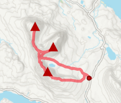
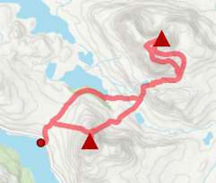
Suilven circuit
Hillwalking route up Suilven from Glencanisp and Kirkaig Falls. A superb circuit from Lochinver, combining Suilven’s ridges and the spectacular falls.
Route outline
| Fionas | ||||
| Ascent | 1425m (4670ft) | |||
| Distance | 22km (14m) | |||
| Time | 7:50hr | |||
| Start | Glencanisp Lodge, Lochinver Grid Ref : NC107220 | |||
| Finish | Inverkirkaig Grid Ref : NC086193 | |||
| Terrain |
| |||
| Nav |
| |||
| Effort |
| |||
| Scenery |
| |||


Starting from Glencanisp and finishing at Inverkirkaig some 6km apart, this route combines the best of Suilven, the Falls of Kirkaig and their surrounding scenery into one circular route.
Suilven's ridge requires a bit of hands-out-of-pockets on the crest to reach its summit, Caisteal Liath. At the opposite end of the ridge is Meall Meadhonach, where scrambling skills and a decent head for heights are needed to reach the top of.
If intending to just aim up Caisteal Liath and return by the same route, it is possible to cycle much of the way to the base of Suilven. Note that the grading for terrain above does not include the detour to Meall Mheadhonach !
Some of the photos below were taken by John King, who regularly guides on Suilven and in the Scottish Highlands.
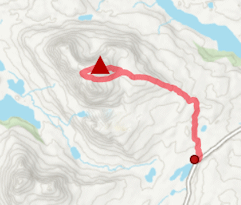
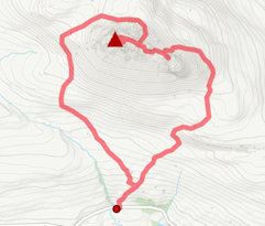
Show map
Route description
1. Getting to Glencanisp

Suilven from Glencanisp Lodge
In the north-west highlands, the A835 travels northwards from Ullapool to meet with the A837 at Ledmore Junction. This road continues further northwards, then west to end at the harbour town of Lochinver.
At the southern end of the town, just before the traffic lights by the turning to the pier, a narrow road heads left (east) and uphill towards Glencanisp. Drive for around 1.5km to the end of the public road, where there is a roadside car-park. At tìme of writing, it was also possible to continue driving to Glencanisp Lodge and park beside some sheds.
If intending to hike the full route, this finishes by Inverkirkaig, around 6km south of Lochinver, therefore a bike or other transport arrangements should be sought to avoid a walk along tarmac at the end of the day.
2. Loch na Gainimh

Suilven from the Glencanisp track
From the car-park at the end of the public road, follow a tarred road towards Glencanisp Lodge  . The road heads through the grounds and comes out by the eastern end of Loch Druim Suardalain, where it becomes a track and meets with a gate
  in a deer-fence.
The track climbs and drops over several bumps over the next 3km, with an ever-improving views of Suilven to the right and Canisp directly ahead, and comes to a junction  - Suileag Bothy is a short detour off left.
Continuing on the main track, a further 2km on, the track crosses the burn heading into Lochan Buidhe via a bridge  , then climbs uphill. Just before approaching Loch na Gainimh, there is a well-constructed path off right (signposted on my last visit)
  .
.
3. Suilven, Caisteal Liath

Caisteal Liath from the col
Now on a well-constructed path heading initially west, hike uphill. The path leads through heather-clad moorland to the base of Suilven by Loch a' Choire Dubh  .
.
Above, the route to Bealach Mòr couldn't be more obvious ! The worn path twists and turns as it climbs steeply up loose sandstone hillside. Just before topping out on the ridge  , there is a little rock jutting out on which to clamber for a fine photo opportunity.
From Bealach Mor, turn right (north-west) and walk along the ridge following a well-defined path. The path heads through a wall, climbs a bit and around halfway up, crosses briefly onto the north side of the crest  .
.
After dropping slightly to a notch, a final pull up a loose section of path reaches the flat, grass covered summit of Caisteal Liath  .
.
4. Detour to Meall Meadhonach

Meall Meadhonach
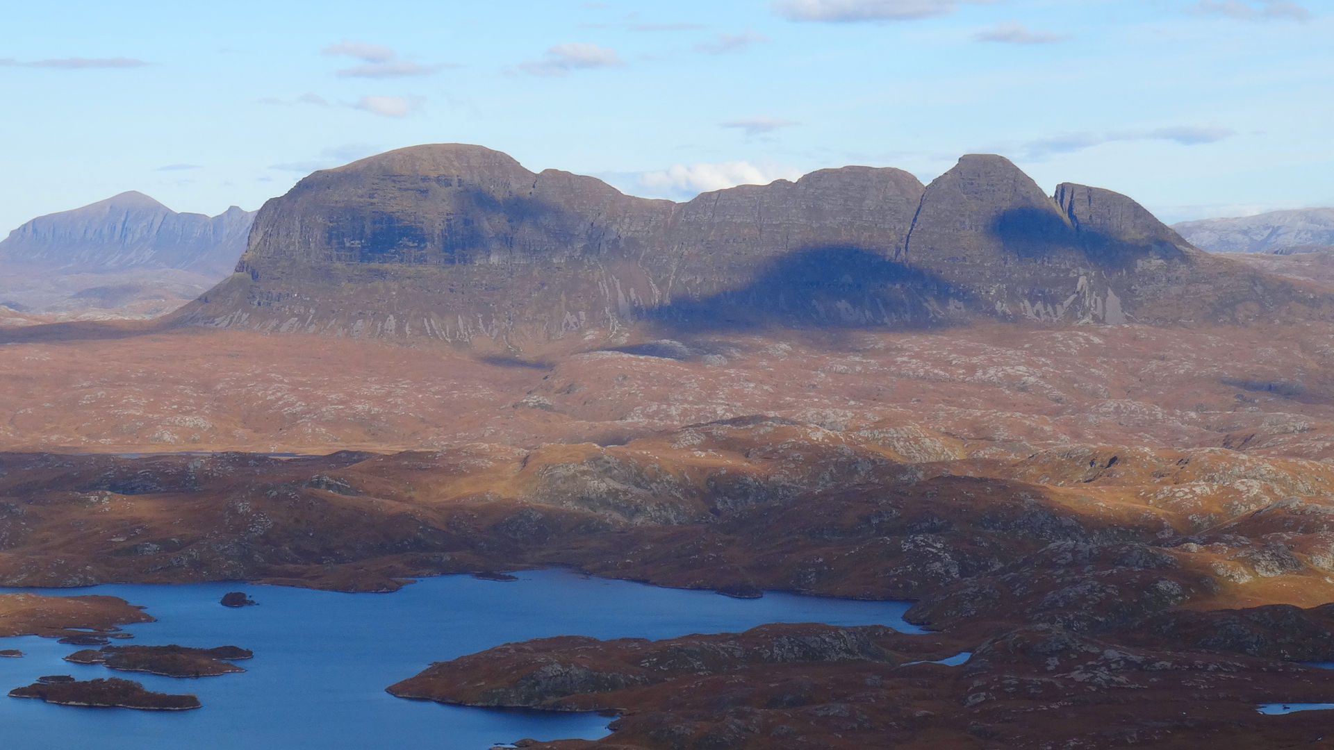
There are 4 peaks on Suilven, Caisteal Liath at the western end, which is the highest, an unnamed peak in the centre and Meall Meadhonach and Meall Beag at the eastern end.
Having hiked to Caisteal Liath, there is the temptation to experience Suilven's ridges and crests further. The unnamed centre peak is similar in terrain to the ridge up to Caisteal Liath, however continuing further eastwards requires good rock-scrambling skills and a decent head for heights ! The route to Meall Mheadhonach is there-and-back and it's worth noting that any rock-scrambling is easier uphill than in reverse !
From Caisteal Liath, return to Bealach Mòr . The path ahead eastwards isn't as worn as the path up Caisteal Liath, suggesting less boot traffic, but is obvious enough as it climbs uphill. Initially quite steep, the path climbs and steps between some rocky ledges. The incline then eases, the path bypasses a bump on the south side of the ridge and meets with a buttress. Around the right of the base of this buttress, then turn left and climb a series of ledges to get on some grassy terrain and reach the summit of the unnamed centre peak  .
.
Continue on the obvious path along Suilven's crest and begin to lose height. The drop to the col before Meall Mheadhonach is straightforward enough apart from one small section of rock needing a careful scramble down.
At the col, immediately ahead, rocky bluffs impede progress. The path heads to the right, then zig-zags a route uphill. Around half way up a rock line blocks progress, turn left under the rock and the path picks a route up onto the next section of grass. The path comes to the bottom of the steepest part of the peak, the trickiest part of the route is now ahead. Directly up some rocky steps, the path turns onto the south side of the crest, climbs gently for a bit then turns northwards. At a scrambling grade of at least Grade 2 and with considerable exposure, climb uphill in a series of ledges onto the grass covered dome of Meall Mheadhonach  with its cairn at the south-eastern end of the peak.

Caisteal Liath from Meall Meadhonach
Caisteal Liath from Meall Meadhonach
5. Descent to Fionn Loch

Suilven above Fhionn Loch
Having returned to Bealach Mòr , have a look over the south side of the mountain. It's steeper than the north side and loose, but descending is much easier than it looks.
A worn path aims generally westwards and loses height as it twists and turns below grass and above scree and heather. After descending around 150m, the path turns more south-westwards and drops through heather to the base of Suilven  at 250m. Now on grass, follow the path as it traces a route by the Alltan Feàrna to meet with a wider path
  travelling along and above the northern shore of Fionn Loch.
6. Falls of Kirkaig and return

Falls of Kirkaig
Follow the path, quite soggy in bits, north-west following the shore of Fionn Loch. The path twist and turns and gradually pulls higher uphill from the shoreline before dropping to cross the loch's outflow  .
.
Having crossed the outflow, the path turns south-east - ignore this and instead turn west and hike up a grassy hillside ahead. A faint trod can be found to trace over heather and grass to reconnect with the path  , just above the Falls of Kirkaig
  . The short detour to a viewpoint across from the waterfall is highly recommended !
Follow the ever-improving path as it makes a way above the River Kirkaig and gradually through woodland for around 3km back to a car-park by the roadside near Inverkirkaig. Above the car-park is the rather eccentric Achins Bookshop and Coffee Shop  (temporarily closed at tìme of writing).
7. Personal note

Me on Suilven in the early 90's
It's 30 years since I was first up Suilven (though possibly also earlier as a child), having clambered up Stac Pollaidh earlier in the day. At that tìme I had a quick skim of the Suilven page in the SMC Guide to "The Corbetts and Other Scottish Hills" and remember thinking how I wasn't quite prepared for the scrambling on Meall Mheadhonach, but still managed it.
Into the late 2010's and when operating my mountain-guiding business, Suilven was frequently requested as a popular hike, possibly on the back of the 'Edie' movie with Sheila Hancock. The non-sensical title of 'Mount Suilven' was used in the movie and for a tìme clients, particularly from North America, referred to the mountain as such !
Route profile »

Maps and GPX downloads »


|
Download GPX of route |

|
Open route in OS Maps |
The map images above link to items on Amazon. A small commission is earned on any map purchased which helps fund the operating costs of this website.
Weather forecasts »
| Regional | MWIS - Northwest Highlands |
| Peak specific | Mountain Forecast.com Met Office YR.no |
| Seasonal | Midge forecast |
Alternative and nearby routes »
Canisp from Loch Awe | |

|
Hillwalking route to Canisp from Loch Awe. A shorter approach than from Glencanisp Lodge, with few paths, but some fine rock formations along the way. Peaks : 1 Corbett
Ascent : 740m (2430ft) Distance : 13km (8m) Time : 4:30hr |
Cul Mòr from Knockan Crag | |
|
Hillwalking route to Cul Mòr from Knockan Crag. A short climb following a good stalker's path most of the way to the rocky summit. Peaks : 1 Corbett
Ascent : 720m (2360ft) Distance : 11km (7m) Time : 4hr |
Stac Pollaidh from Loch Lurgainn | |
|
Hillwalking route up Stac Pollaidh from Loch Lurgainn. A short, popular circuit on good paths, with scrambling needed to reach the true top. Peaks : 1 Fiona
Ascent : 575m (1890ft) Distance : 5km (3m) Time : 2hr |
Quinag from above Loch Assynt | |
|
Hillwalking route bagging Spidean Coinich, Sàil Gharbh and Sàil Ghorm on Quinag. A superb route covering all 3 Corbett summits on this rugged massif. Peaks : 3 Corbetts
Ascent : 1150m (3770ft) Distance : 13km (8m) Time : 5:10hr |
Cul Beag and Cul Mòr | |
|
Hillwalking route up Cul Beag and Cul Mòr from Loch Lurgainn. A rough outing through Inverpolly’s lochans and forests linking the two summits. Peaks : 2 Corbetts
Ascent : 1650m (5410ft) Distance : 16km (10m) Time : 6:25hr |


