

Càrn an t-Sagairt Mòr and Auchallater Munros
Route up Càrn an t-Sagairt Mòr from Glen Callater, with options to extend to several other Munros encircling the glen on fine tracks.
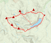
Route outline
| Munros | ||||
| Walk ascent | 850m (2780ft) | |||
| distance | 26km (16m) | |||
| time | 8:00hr | |||
| Bike ascent | 190m (620ft) | |||
| distance | 10km (6m) | |||
| time | 1:00hr | |||
| Start/finish | Auchallater, Braemar Grid Ref : NO156881 | |||
| Terrain |
| |||
| Nav |
| |||
| Effort |
| |||
| Scenery |
| |||


The route begins on an estate track tracing the course of "Old Jocks Road", a drove route between Glen Callater and Glen Clova. A mountain-bike will make quick and easy progress for the 5km along this section to Lochcallater Lodge. Beyond this and on foot, a fine but rough path takes over. leading uphill towards Càrn an t-Sagairt Mòr. Higher up the rolling hills and wide crests have faint paths to trace to Cairn Bannoch and Broad Cairn. The few defining features will test navigation skills in mist or white-out conditions.
The route could be extended to include Tom Buidhe, Tolmount and even Cairn of Claise and Càrn an Tuirc. Some fence-posts will aid navigation, but in the main expect to be away from paths for much of the distance.
Show map

Route description
1. Getting to Auchallater

Bridge over the River Callater
The A93 connects Perth with Aberdeen, passing through Braemar in Deeside. A couple of miles south of Braemar on a bend in the road and by the bridge over Callater Burn, is Auchallater farm. On the opposite side of the road there is a car-park with information board - there is a charge to park (£2.50 at tìme of writing).
2. Càrn an t-Sagairt Mor

On Carn an t-Sagairt Mor's summit
A Right-of-way sign points the way in up a fine estate track initially heading south-east. Walk or cycle up this track for 5km, crossing Callater Burn on a bridge  on the way, to Lochallater Lodge.
  . If cycling, leave bikes here.
On a path, head around the lodge the north side of the lodge and begin hiking uphill. The path climbs directly uphill for just over 50m, then turns south-east and climbs more gently overlooking Loch Callater with views opening up southwards to Glen Callater and Coire Loch Kander.
The path begins to swing away from Loch Callater, and aims around Creag an Loch  then begins up the northern shoulder of Càrn an t-Sagairt Mòr. At around c900m, you could continue on the gently rising path, but we left the path here and made a direct route through heather and some boulders up to Càrn an t-Sagairt Mòr's summit.
To the north-east of the summit is some scattered plane wreckage, including a large section of wing  . These pieces are the remains of a Canberra jet that crashed into the hill in 1956.
Càrn an t-Sagairt Mòr's summit  has two cairns (the southern one indicates the highest point) from where excellent views are to be had on clear days.
3. Cairn Bannoch

Cairn Bannoch from slopes of Cairn of Gowal
Beyond Càrn an t-Sagairt Mor, there's very little ascent left ! Having left Càrn an t-Sagairt Mòr's southern cairn and on a faint path, aim south-east downhill. The path becomes more obvious as it loses height. The bealach between Càrn an t-Sagairt Mòr and Cairn Bannoch is approached where terrain is more gentle and grass covered.
Cross the wide bealach, you may well meet up with folk coming in on the paths from Auchallater and Fafernie  .
.
Cairn Bannoch comes into view and the last few metres of climb up to Cairn Bannoch's summit  require a bit of clambering over some large boulders.
4. Broad Cairn

Braod Cairn from Cairn Bannoch
From Cairn Bannoch, head south-east and up the bump marked 991m  . Nearby Cairn of Gowal
  can be bypassed as you hike downhill, south-east on a faint path over grassy ground to reach an unusual bealach with three summits of Cairn of Gowal, Creagan Dubh-loch and Broad Cairn radiating out from it.
A quick walk over more flat grass covered ground and one last clamber up bouldery ground gain's Broad Cairn's summit  . Good views, particularly down Loch Muick and out to Mount Keen.
5. Return to Auchallater

Re-tracing steps back from Broad Cairn towards Cairn Bannoch
From Broad Cairn, several options now present themselves !
You could return to Cairn Bannoch , then drop to the col below Càrn an t-Sagairt Mòr and pick up the path to re-trace your steps down to Auchallater Lodge .
Alternatively, after returning to Cairn of Gowal , aim directly for 'Old Jocks Road'  at the col between Knaps of Fafernie and Crow Craigies. Follow this path down Loch Callater and back to Auchallater Lodge .
Or if you're feeling fit and the sun is out, why not continue westwards from the col between Knaps of Fafernie and Crow Craigies and bag some more Munros ? Tolmount  , Tom Buidhe
  , Cairn of Claise
  and Càrn an Tuirc
  can be hiked in a linear route, followed by a descent down Càrn an Tuirc's northern shoulder to Lochcallater Lodge .
Route profile »

Maps and GPX downloads »


The map images above link to items on Amazon. A small commission is earned on any map purchased which helps fund the operating costs of this website.
Weather forecasts »
| Regional | MWIS - Southeast Highlands |
| Peak specific | Mountain Forecast.com Met Office YR.no |
| Seasonal | SAIS - Southern Cairngorms Midge forecast |
Alternative and nearby routes »
East of Glenshee | |

|
Hillwalking route over the 4 Munros east of Glenshee, dominated by Glas Maol. High, vast, and pathless, with the option to add Creag nan Gabhar. Peaks : 4 Munros, option of 1 Corbett
Ascent : 910m (2990ft) Distance : 15km (9m) Time : 5:15hr |
Lochnagar and Loch Muick circuit | |
|
Hillwalking route over Lochnagar and its 4 neighbouring Munros above Loch Muick in Royal Deeside, forming a classic high-level circuit. Peaks : 5 Munros, 1 Corbett
Ascent : 1340m (4400ft) Distance : 28km (17m) Time : 9:15hr |
Morrone from Braemar | |

|
A short hillwalk from Braemar up a fine, if rather rough path to the top of Morrone - a superb viewpoint to survey the southern Cairngorms. Peaks : 1 Corbett
Ascent : 480m (1570ft) Distance : 6km (4m) Time : 2:25hr |
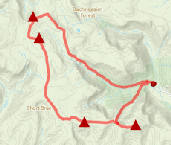
Munros above Jock's Road | |
|
Route over Driesh, Mayar, Tom Buidhe and Tolmount above Jock’s Road. A grassy circuit with little feature, sure to test navigation skills. Peaks : 4 Munros
Ascent : 1375m (4510ft) Distance : 26km (16m) Time : 9hr |
Driesh and Mayar | |

|
Hillwalking route up Driesh and Mayar above Glen Doll in the Angus Glens. Easy paths make these Munro twins ideal for a shorter day. Peaks : 2 Munros
Ascent : 900m (2950ft) Distance : 14km (9m) Time : 5hr |


