

Ben Vuirich from Tarvie
Route up Ben Vuirich from Tarvie in Glen Brerachan. An estate track eases the first half, before pathless grassy slopes rise to the summit trig point.
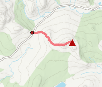
Route outline
| Corbetts | ||||
| Ascent | 630m (2060ft) | |||
| Distance | 15km (9m) | |||
| Time | 5:00hr | |||
| Start/finish | Tarvie, Glen Brerachan Grid Ref : NO019638 | |||
| Terrain |
| |||
| Nav |
| |||
| Effort |
| |||
| Scenery |
| |||


Access to the foot of Ben Vuirich is along excellent estate tracks and paths. Higher up the ground is heather clad ground and fairly pathless, testing navigation skills, even in clear conditions.
Show map

Route description
1. Getting to Tarvie

The first view of Ben Vuirich from above Tarvie
The A924 road travels from Pitlochry uphill to Glen Brerachan eventually making a way through Strathardle to Bridge of Cally a few miles north of Blairgowrie.
A couple of kilometres to the north-east of the highest point of the road, the road crosses Brerachan Water, nearby is a flat roadside gravel area with room for a few vehicles to park.
The route to Ben Vuirich begins by the entrance to Tarvie, which is around 500m east of the parking area.
Around half of this route is on a decent estate track, good enough to cycle on !
2. Tarvie Burn

Loch Tarvie, Ben Vuirich's Carn Dubh on left
At the entrance to Tarvie there is a white house, to the right of this is a tarred road - head up this for 500m throuugh woodland. You'll come to Tarvie House  - an impressive architect designed contemporary house. Go northwards and round the house, out of woodland and to a gate.
Through the gate and into a field (most likely with sheep), the track is faint making a route uphill and over grass towards a fenced-off area of forestry. Beyond this grouping of trees, the track's incline becomes more gentle as it makes its way to the edge of the field and to another gate. Through the gate and Tarvie Loch  with its small boat house is met. Càrn Dubh, the south 'top' of Ben Vuirich can be seen ahead.
Continue northwards past the loch on the track. The track crosses Tarvie Burn by a foot bridge, then later again by a ford. A bit further on the track comes to a junction  - if you're cycling, best leave bikes here.
3. Ben Vuirich

Càrn Liath from Ben Vuirich's summit
From the junction, the track on the left carries north-west for around 500m then stops abrupty below deep heather. The track on the right follows Tarvie Burn further, to easier ground to climb up Ben Vuirich. Therefore, I took an anti-clockwise route leaving the deep heather-clad ground for the descent.
So, from the junction , head north following the now faint track for around 500m, crossing the Allt an Fheadain burn on the way, while keeping Tarvie Burn on your right. As the track begins to turn slightly north-east, leave it and head north-west crossing tussocky ground, quite damp in places to the base of Ben Vuirich's south-east top, Càrn Dubh.
Ahead the ground steepens and becomes more heather-clad with no path to be found. A bit of a trudge up the steep ground through heather leads onto the crest of the hill just south of Càrn Dubh.
Once on the crest, aim for the bealach  between Càrn Dubh and Ben Vuirich where a faint path can be picked up and followed. This leads to Ben Vuirich's summit
  where a trig point stands encircled by a stone shelter.
4. Return

Bothy above Tarvie Burn
You could simply return by the same route !
Alternatively, after retracing your steps for around a kilomtre and a half to just south of Càrn Dubh, take a slight detour by heading south-west. A route travelling over Druim Mòr which in most conditions should be drier underfoot than the way up.
Gradually turning south-east, a path forms which drops to an old building  beside which a track is picked up. This track is followed for around 500m back down to Tarvie Burn and the track hiked up earlier is traced back to Tarvie.
Route profile »

Maps and GPX downloads »


|
Download GPX of route |

|
Open route in OS Maps |
The map images above link to items on Amazon. A small commission is earned on any map purchased which helps fund the operating costs of this website.
Weather forecasts »
| Regional | MWIS - Southeast Highlands |
| Peak specific | Mountain Forecast.com Met Office YR.no |
| Seasonal | SAIS - Southern Cairngorms Midge forecast |
Alternative and nearby routes »
Ben Vuirich from Atholl | |

|
Hillwalking oute up Ben Vuirich from Loch Moraig near Blair Atholl. Estate tracks rise to grass and heather slopes leading to a lonely trig-point summit. Peaks : 1 Corbett
Ascent : 860m (2820ft) Distance : 20km (12m) Time : 6:30hr |
Blath Bhalg from Glen Brerachan | |
|
Short hillwalk up Blath Bhalg from Glen Brerachan following a faint path to summit gives big views over the southern Cairngorms and Lochnagar. Peaks : 1 Fiona/Graham
Ascent : 350m (1150ft) Distance : 7km (4m) Time : 2:20hr |
Ben Gulabin from Spittal of Glenshee | |

|
Hillwalking route up Ben Gulabin from Spittal of Glenshee. A short, straightforward climb on estate tracks and a worn path all the way to the summit. Peaks : 1 Corbett, option to extend
Ascent : 450m (1480ft) Distance : 5km (3m) Time : 2hr |
Ben Vrackie from Moulin | |

|
Hillwalking route up Ben Vrackie from Moulin Hotel. A fine path leads from Pitlochry to the summit, with superb views of the Southern and Eastern Highlands. Peaks : 1 Corbett
Ascent : 675m (2210ft) Distance : 9km (6m) Time : 3:25hr |
Beinn a' Ghlo from Blair Atholl | |

|
Hillwalking route on Beinn a’ Ghlo above Blair Atholl and Glen Tilt. This vast massif has 3 Munros: Càrn Liath, Bràigh Chruinn-bhalgain and Càrn nan Gabhar. Peaks : 3 Munros
Ascent : 1350m (4430ft) Distance : 20km (12m) Time : 7:15hr |


