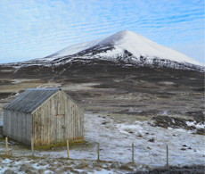
Càrn a' Chlamain
North of Blair Atholl a network of estate tracks encourage cycling to reach the remote area north of Glen Tilt where pointy summit of Càrn a' Chlamain rests.
Càrn a' Chlamain
| Height | 963.5m |
| Prominence | 317m |
| Meaning | cairn of the kite |
| Lists | Munros, 192 |
| Location | Glen Bruar to Glen Tilt, Gaick and Atholl |
| Grid Ref | NN916758 |
| Lat/Lon | 56.86099, -3.77692 |
The conical and bouldery summit of Càrn a' Chlamain sits above a vast expanse of high-level heather-clad Tarf moorland that is split by a variety of corries.
To the south-east of Càrn a' Chlamain is Glen Tilt, along which most hillwalkers will approach the base of this shy Munro typically by bike. Along with the fine track up most of Càrn a' Chlamain's south-west shoulder, this makes for a short outing. The day can easily be extended onto nearby Corbett of Beinn Mheadhonach or Munro of Beinn Dearg, but with a lack of paths, navigation skills will be tested !
Routes up Càrn a' Chlamain
Càrn a' Chlamain via Glen Tilt | |

|
Hiking and biking route up Càrn a’ Chlamain from Blair Atholl via Glen Tilt. An estate track follows the River Tilt before a climb to the bouldery summit. Peaks : 1 Munro
Ascent : 1090m (3580ft) Distance : 26km (16m) Time : 5hr |
Beinn a' Ghlo to Beinn Dearg | |

|
A long hillwalking route over 5 Munros and a Corbett above Glen Bruar and Glen Tilt, including peaks on Beinn a’ Ghlo, Càrn a’ Chlamain and Beinn Dearg. Peaks : 5 Munros, 1 Corbett
Ascent : 2850m (9350ft) Distance : 42km (26m) Time : 15hr |
Nearby hills and mountains


