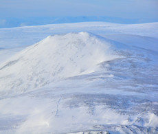
Càrn Liath, Beinn a' Ghlo
Càrn Liath, the most southerly Munro of Beinn a' Ghlo, is distinctive from the A9 above Blair Atholl, with a scarred path up its south-west shoulder.
Càrn Liath, Beinn a' Ghlo
| Height | 976m |
| Prominence | 211m |
| Meaning | mountain of mist - grey hill |
| Lists | Munros, 179 |
| Location | Glen Tilt to Glen Brerachan, Gaick and Atholl |
| Grid Ref | NN936698 |
| Lat/Lon | 56.80789, -3.74399 |
Beinn a' Ghlo is a massive and complex mountain range towering above Blair Atholl and Glen Tilt. The most southerly peak of this range is Càrn Liath, a fine Munro of conical shape as seen from the south-west.
On its own, a hike up Càrn Liath requires a mere ascent of 640m over a distance of 8km (there-and-back) and is therefore one of the easiest Munros to bag, with a well-worn path meandering up its south-west shoulder.
Continuing further from Càrn Liath over the other summits on Beinn a' Ghlo, a relaxed route following crests and faint paths takes in Bràigh Coire Chruinn-bhalgain and Càrn nan Gabhar, returning to Blair Atholl on a delightful path and estate track.
Other options include detouring to nearby Corbett of Ben Vuirich or extending the route further with a fair bit of effort and ascent to bag nearby peaks of Càrn a' Chlamain, Beinn Mheadhonach or even Beinn Dearg.
Routes up Càrn Liath
Beinn a' Ghlo from Blair Atholl | |

|
Hillwalking route on Beinn a’ Ghlo above Blair Atholl and Glen Tilt. This vast massif has 3 Munros: Càrn Liath, Bràigh Chruinn-bhalgain and Càrn nan Gabhar. Peaks : 3 Munros
Ascent : 1350m (4430ft) Distance : 20km (12m) Time : 7:15hr |
Beinn a' Ghlo to Beinn Dearg | |

|
A long hillwalking route over 5 Munros and a Corbett above Glen Bruar and Glen Tilt, including peaks on Beinn a’ Ghlo, Càrn a’ Chlamain and Beinn Dearg. Peaks : 5 Munros, 1 Corbett
Ascent : 2850m (9350ft) Distance : 42km (26m) Time : 15hr |
Nearby hills and mountains


