

Càrn Chuinneag from Glen Calvie – hillwalk & cycle
Cycle or walk through Glen Calvie’s woodland then climb Càrn Chuinneag's twin summits via stalkers path on this remote Corbett route.
Route outline
| Corbetts | ||||
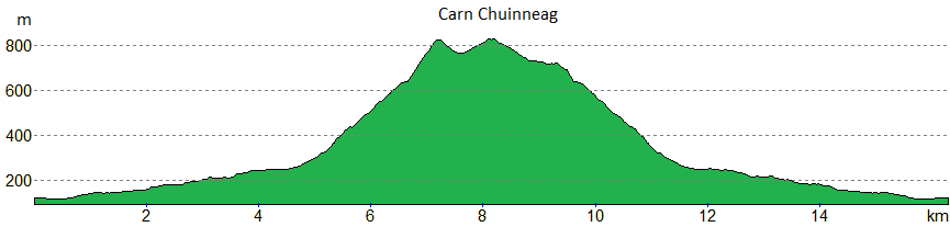
| Ascent | 780m (2550ft) | |||
| Distance | 16km (10m) | |||
| Time | 5:20hr | |||
| Start/finish | Glencalvie Lodge, Strathcarron Grid Ref : NH464891 | |||
| Terrain |
| |||
| Nav |
| |||
| Effort |
| |||
| Scenery |
| |||


This route begins from the end of the public road in Strathcarron, west of Ardgay and takes estate tracks to the foot of Càrn Chuinneag. Thereafter stalkers paths ease access up to this little hill's summit crest, from where fine views can be had from the twin tops.
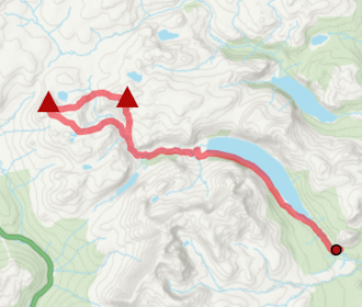
The route to the foot of Càrn Chuinneag through Glen Calvie is 4km and on a fine estate track - perfect for cycling on (a hybrid-bike will easily cope with the track surface).
Show map
Route description
1. Getting to Strathcarron

Gorge on River Carron
North of Inverness, the A9 heads over the Black Isle to the Dornoch Firth, at the head of which is Ardgay. A narrow road heads westwards from this village, at the end of which is a turning area by the entrances to Glencalvie Estate and Alladale Wilderness Reserve.
By the turning area there is limited parking for a few vehicles. If full, there are several roadside laybys on the road approach.
2. Glen Calvie

Carn Chuinneag from Glen Calvie
From the parking area, cross the road and head downhill to a bridge over a river. As a small detour, heading westwards (signposted) for 500m or so, a path leads to the lovely little waterfall of Eas Charron.
Follow the road as it passes a magnificent tree house, heads around Glencalvie Lodge  and passes some houses before heading into birch woodland by the Water of Glencalvie.
Now on an estate track, follow the track as it progresses southwards through woodland, crossing the Water of Glencalvie  . Through a gate
  and out of most of the woodland, the western summit of Càrn Chuinneag comes into view ahead.
After a further 3km on the track, the track swings eastwards, by which is a small untidy cairn  marking the start of a stalkers path heading uphill.
3. Càrn Chuinneag

On Càrn Chuinneag's summit looking to Ben Wyvis
The stalkers path heads up the shoulder of Càrn Chuinneag's western peak. It's grassy and soggy in bits as it twists a route up the steep side of A' Chìoch. There's a little respite before the path hits screes, then zig-zags uphill.
The path levels out and comes to a junction with a cairn  - turn sharp left (north-east).
If you're like me, you'll be wanting to get to the top of both peaks, therefore you'll need to leave the path and strike directly up the fall-line over heather and some boulderfield to aim for the westerly summit  . The top of this is quite rocky, a bit reminiscent of Ben Avon, albeit on a much smaller scale.
The route to the main summit from the westerly top is pathless but straightforward, simply aim eastwards, dropping around 50m on a wide bealach, followed by a gentle climb as you try to keep to grass-covered terrain.
Càrn Chuinneag's main summit  is a rocky place where a trig point stands partically protected by a circular dyke. Fine views in all directions !
4. Return

Descending the stalkers path on Càrn Chuinneag
From Càrn Chuinneag's summit, begin to retrace your steps north-westwards. Instead of turning westwards to the wide bealach, keep north-westwards and descend downhill where you'll meet up with the path again  , around 1km east of where it was left.
Follow the path westwards around Càrn Chuinneag's westerly summit to meet up with the junction .
Retrace your steps back to the estate track below A' Chìoch and return through Glen Calvie to the roadside.
Route profile »
Maps and GPX downloads »


|
Download GPX of route |

|
Open route in OS Maps |
The map images above link to items on Amazon. A small commission is earned on any map purchased which helps fund the operating costs of this website.
Weather forecasts »
| Regional | MWIS - Northwest Highlands |
| Peak specific | Mountain Forecast.com Met Office YR.no |
| Seasonal | SAIS - Torridon Midge forecast |
Alternative and nearby routes »
Beinn nan Eun & Càrn Loch nan Amhaichean Route Guide | |
|
Cycle and hike to the Grahams Beinn nan Eun and Càrn Loch nan Amhaichean from Glen Glass. A remote route with panoramic Highland views. Peaks : 2 Grahams/Fionas
Ascent : 1040m (3410ft) Distance : 39km (24m) Time : 6hr |
Meall Mòr from Glen Glass hillwalk route | |

|
Hike Meall Mòr from Glen Glass through old estate tracks and open moorland for superb views over the forested lands and Northern Highlands. Peaks : 1 Fiona/Graham
Ascent : 650m (2130ft) Distance : 15km (9m) Time : 4:50hr |
Beinn Tharsuinn from Strath Rusdale hillwalk | |

|
Hillwalking route up Beinn Tharsuinn from Strath Rusdale. Quick ascent via estate track leads to wide summit ridge with quiet traverse and fine views. Peaks : 1 Fiona/Graham
Ascent : 560m (1840ft) Distance : 12km (7m) Time : 4hr |
Càrn Bàn & Beinn a' Chaisteil – bike & hike route | |

|
Bike through Alladale’s wild tracks to reach Càrn Bàn and Beinn a' Chaisteil – remote Corbett hills in the Strathvaich wilderness. Peaks : 2 Corbetts
Ascent : 1400m (4590ft) Distance : 47km (29m) Time : 7:25hr |
Seana Bhraigh from Corriemulzie | |

|
Hike and bike route up Seana Bhraigh from Oykel Bridge and Corriemulzie. Drive, cycle, then hike heather slopes for the easiest approach to this remote Munro. Peaks : 1 Munro
Ascent : 930m (3050ft) Distance : 27km (17m) Time : 4:30hr |


