

Beinn Tharsuinn from Strath Rusdale hillwalk
Hillwalking route up Beinn Tharsuinn from Strath Rusdale. Quick ascent via estate track leads to wide summit ridge with quiet traverse and fine views.
Route outline
| Fionas | ||||
| Ascent | 560m (1830ft) | |||
| Distance | 12km (8m) | |||
| Time | 4:00hr | |||
| Start/finish | Braeantra, Strath Rusdale Grid Ref : NH569779 | |||
| Terrain |
| |||
| Nav |
| |||
| Effort |
| |||
| Scenery |
| |||


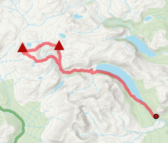
The ascent of Beinn Tharsuinn from Strath Rusdale begins on an estate track that climbs steadily up the hill's western side, allowing for fast and easy progress to reach the turbines of Coire na Cloiche wind farm. From there, a short climb up a heather-clad slope leads to a broad, open summit expanse where a path comes and goes as it travels through a patchwork of peat hags between a trig point on Beinn Tharsuinn's southern summit and a large cairn on Sìthean a' Choin Bhan, the hill's northern high point.
Show map
Route description
1. Getting to Strath Rusdale

The track leading up from 'Keeper's Cottage'
From the northern side of the Cromarty Firth, take the A9 heading north from near Dingwall towards Alness. Just before reaching Alness, turn off onto the B9176, which cuts across moorland heading north. Around 6km from the A9 junction, you'll reach the small school by Easter Ardross. Here, take the minor road heading west.
Follow this single-track road for roughly 10km. Travelling up Strath Rusdale, it winds past Ardross Castle and gradually narrows, eventually ending near the entrance to the Kildermorie Estate. Just before the estate gates, there's space to park a car or two by the bins for 'Keeper's Cottage'.
2. Beinn Tharsuinn

Further up the track, wind turbines come into view
Starting from the roadside, following a good estate track that climbs steeply through a gate in a deer fence and into mixed forestry. The track (shown on OS 1:25,000 maps but not on the 1:50,000) continues uphill through woodland for about 1.5km before emerging into open ground. It then passes through a second high gate in a deer fence and reaches a small dam  , where the OS 1:25,000 map shows the track ending.
From here, a smoother continuation of the track leads gently uphill, arriving at the southernmost turbine  of the Coire na Cloiche wind farm, nestled beneath Beinn Tharsuinn's western flanks.
Leaving the track at this point, head east, initially losing a bit of height while crossing tussocky ground and short heather. After fording a small burn, aim directly for a distinctive rock feature  on the skyline. This turns out to be two large granite boulders sitting side by side.

On Beinn Tharsuinn's summit looking over the Cromarty Firth
 marking Beinn Tharsuinn's summit. The views are a pleasant surprise - expansive and far-reaching, especially over the Cromarty Firth to the south and stretching north and west to the distant mountains of Assynt, Coigach, and Inverlael.
On Beinn Tharsuinn's summit looking over the Cromarty Firth
3. Return over Sìthean a' Choin Bhain

On the way to Sìthean a' Choin Bhain
You could simply retrace your steps from here, but with such a short ascent so far, why stop now ?
Instead, follow the faint path northward along the summit expanse. It quickly fades away into the maze of peat hags, and any notion of a direct route disappears. Thankfully, in dry conditions, the ground is soft and springy, making this traverse quite enjoyable - though it could be a different story after rain !
Continue past Beinn Tharsuinn's northern top  (once believed to be of equal height to the southern summit), then visit the well-built cairn
  just to the north. This is the best viewpoint of the entire route - offering vast, uninterrupted panoramas over Càrn Chuinneag and the Flow Country to Ben Klibreck, Ben Hope, and the hills of Assynt and Coigach. Genuinely breathtaking.

Descending back down to the Coire na Cloiche wind farm
 , gradually aiming for the southernmost turbine , then rejoin the track for a relaxed jog or walk back down to the roadside.
Descending back down to the Coire na Cloiche wind farm
Route profile »

Maps and GPX downloads »


|
Download GPX of route |

|
Open route in OS Maps |
The map images above link to items on Amazon. A small commission is earned on any map purchased which helps fund the operating costs of this website.
Weather forecasts »
| Regional | MWIS - Northwest Highlands |
| Peak specific | Mountain Forecast.com Met Office YR.no |
| Seasonal | SAIS - Torridon Midge forecast |
Alternative and nearby routes »
Meall Mòr from Glen Glass hillwalk route | |

|
Hike Meall Mòr from Glen Glass through old estate tracks and open moorland for superb views over the forested lands and Northern Highlands. Peaks : 1 Fiona/Graham
Ascent : 650m (2130ft) Distance : 15km (9m) Time : 4:50hr |
Càrn Chuinneag from Glen Calvie – hillwalk & cycle | |

|
Cycle or walk through Glen Calvie’s woodland then climb Càrn Chuinneag's twin summits via stalkers path on this remote Corbett route. Peaks : 1 Corbett
Ascent : 780m (2560ft) Distance : 16km (10m) Time : 5:20hr |
Beinn nan Eun & Càrn Loch nan Amhaichean Route Guide | |
|
Cycle and hike to the Grahams Beinn nan Eun and Càrn Loch nan Amhaichean from Glen Glass. A remote route with panoramic Highland views. Peaks : 2 Grahams/Fionas
Ascent : 1040m (3410ft) Distance : 39km (24m) Time : 6hr |
Ben Wyvis from Garbat | |

|
Hillwalking route from the forests of Strathgarve to Ben Wyvis's summit Glas Leathad Mòr, extendable over other Munro Tops and Little Wyvis. Peaks : 1 Munro, option of 1 Corbett
Ascent : 910m (2990ft) Distance : 14km (9m) Time : 4:35hr |
Càrn Bàn & Beinn a' Chaisteil – bike & hike route | |

|
Bike through Alladale’s wild tracks to reach Càrn Bàn and Beinn a' Chaisteil – remote Corbett hills in the Strathvaich wilderness. Peaks : 2 Corbetts
Ascent : 1400m (4590ft) Distance : 47km (29m) Time : 7:25hr |


