
Coulin Forest from Glen Torridon
Hillwalking route from Glen Torridon up Munros and Corbetts in Coulin Forest. Beinn Liath Mhòr, Sgòrr Ruadh, Sgùrr Dubh and Sgòrr nan Lochan Uaine.
Route outline
| Munros | ||||
| Corbetts | ||||
| Ascent | 1750m (5740ft) | |||
| Distance | 21km (13m) | |||
| Time | 8:10hr* | |||
| Start/finish | Glen Torridon, 5km east of Torridon Village Grid Ref : NG958568 | |||
| Terrain |
| |||
| Nav |
| |||
| Effort |
| |||
| Scenery |
| |||


When Torridon's weather is grey and overcast, the tops of its higher peaks can be sulking in thick mist - often at this time the peaks of Coulin Forest will be below the cloud base.
Starting from Glen Torridon, this route begins and ends on a rough Right-of-Way path travelling through an interesting morraine pitted landscape. Higher up there there is much boulderfield to contend with and there are no paths on either of the rugged Corbett peaks nor on route up to Beinn Liath Mhòr. Terrain continues to be rough on Beinn Liath Mhòr and Sgòrr Ruadh, though fairly well defined boot-worn paths cross the crests of these Munro mountains.
The route can easily be split into two shorter routes.
Route map

Route description
1. Getting there

Start of route in Glen Torridon
Torridon is a small village, some 10miles west of Loch Maree in the north-west highlands. The A896 connects Loch Maree to the village and travels the length of Glen Torridon. This road is narrow and single track for the most part, and being on the NC500 scenic route, can be busy in peak holiday periods !
The hike up the peaks of Coulin Forest from Glen Torridon begins from the car-park at the foot of Stùc a' Choire Dhuibh Bhig on the easatern end of Liathach, around 5km to the east of Torridon village.
2. Sgùrr Dubh

Lochan below Sgurr Dubh's summit
From the car-park at the foot of Liathach's eastern end, cross the bridge over the Allt a' Choire Dhuibh Mhòr.
On the south side of the road you'll find a sign indicating the start of a Right-of-Way. This path aims south-east towards a wooden bridge over the Feith Ghlas burn.
Cross this bridge and follow the path southwards, meeting with Lochan an Iasgair and then Ling Hut  (an SMC club bothy).
After passing the bothy and then a ruin, the path climbs and passes a waterfall.
(an SMC club bothy).
After passing the bothy and then a ruin, the path climbs and passes a waterfall.
The route turns south, climbs slightly, crosses a small burn, then meets up with a slightly larger burn, the Allt nan Corrag  , heading down from Sgùrr Dubh.
Keeping to the north side of this burn, leave the path here and head south-east over heather and soggy ground.
, heading down from Sgùrr Dubh.
Keeping to the north side of this burn, leave the path here and head south-east over heather and soggy ground.
The morraine landscape of this area is most intriguing, and reveals its secrets as height is gained.
Faint occasional traces of trods can be found as the Allt nan Corrag is followed to the base of rocky ground  . Ascent now much steeper, the edge of a long deep cleft is met and followed up to around c500m.

Liathach from summit of Sgùrr Dubh
 , particularly over Glen Torridon to Beinn Eighe and Liathach.
Liathach from summit of Sgùrr Dubh
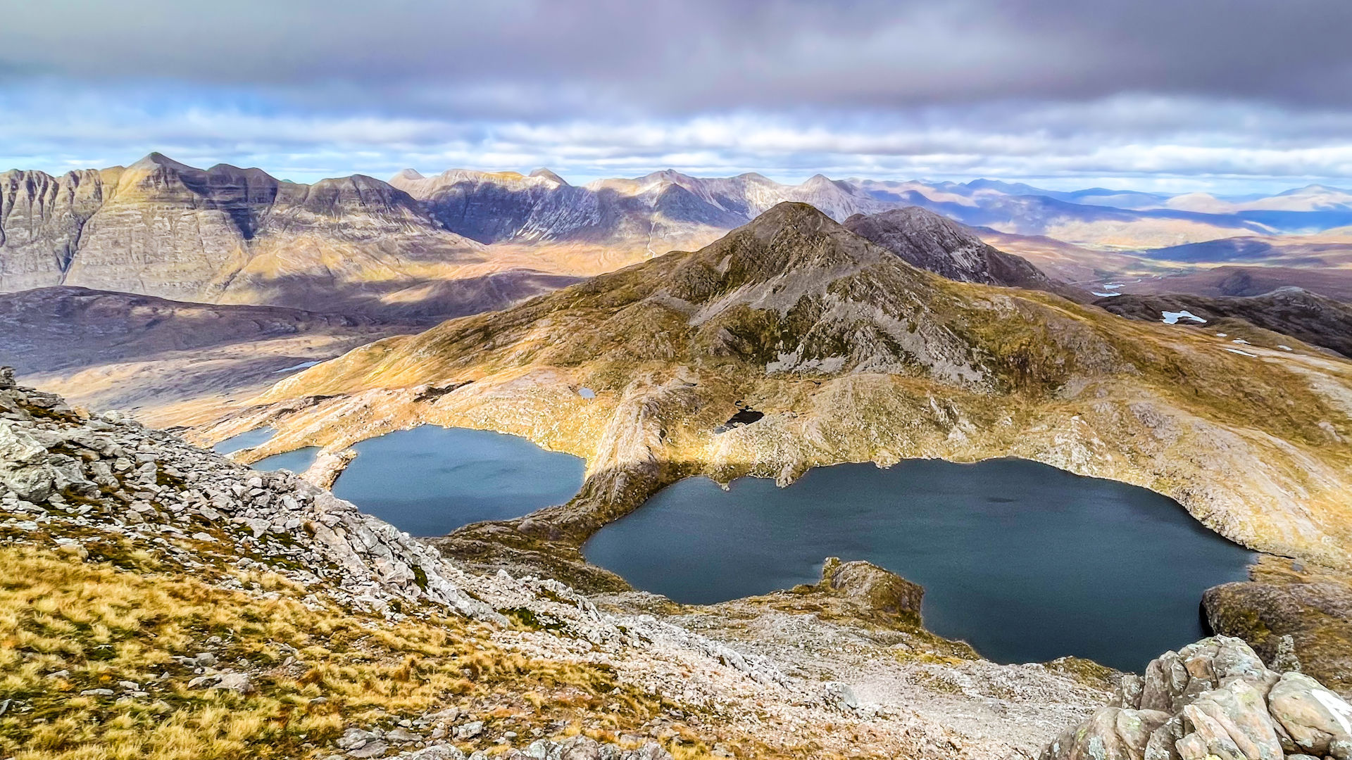
3. Sgòrr nan Lochain Uaine

Below Sgùrr Dubh's cliffs, Sgòrr nan Lochan Uaine ahead
Terrain between Sgùrr Dubh and Sgòrr nan Lochain Uaine is undulating, pitted with lochans and constantly changes between grass and boulderfield. Navigation in less than idealy conditions will be testing !
On Sgùrr Dubh's summit, about turn and retrace your steps down the boulderfield, pass the little lochans and lose height of around 100m.
Turn southwards and hike on a faint trod through heather and below some cliffs while aiming for a large lochan  ahead and below.
Over or around a minor bump, travel past some weird erratic boulders.
ahead and below.
Over or around a minor bump, travel past some weird erratic boulders.
The route continues by passing another lochan, and crossing more grassy, undulating ground to meet with the lochan  at the lowest point between the two Corbetts. Ahead a straightforward and gradual rise meets up with more boulderfield for the final climb up to Sgùrr nan Lochan Uaine's summit
  .
.

Final pull to Sgùrr Dubh's summit
Final pull to Sgùrr Dubh's summit
4. Beinn Liath Mhor

Beinn Liath Mhòr above Lochan Uaine
Having reached the summit of Sgòrr nan Lochan Uaine, this is the point at which to decide whether or not to continue onwards and up the Coulin Forest Munros, or to bale out in the satisfaction of having bagged two Corbetts. See the section below for splitting the route, read on if intending to head up more peaks !
On the summit of Sgòrr nan Lochan Uaine head just east of south for around 100m or so before turning south-east. Now losing some height on bouldery ground, aim for easier grassy terrain to ease ankles for the hike down to the Lochan Uaine's outflowing burn  .
.
Above and ahead, a route up Beinn Liath Mhòr doesn't look too obvious, but instead appears rather intimidating. Once over the burn, keep to the grassy crest of the shoulder ahead and reach the bottom of some steep ground  . Underfoot is a bit loose, but there's only one slight awkward bit of clambering involved, followed by a pleasant walk up onto Beinn Liath Mhòr's crest
  around 500m east of its summit.

On Beinn Liath Mhòr looking to Liathach
 with its large cairn. The view back over Sgùrr nan Lochan Uaine and the rugged landscape is quite exceptional !
On Beinn Liath Mhòr looking to Liathach
5. Sgòrr Ruadh

Descending Beinn Liath Mhor
Beinn Liath Mhòr's summit is made of shattered quartzite boulders, therefore care is needed when crossing the ground in wet conditions, as the rock can be very slippy !
Aim west from Beinn Liath Mhòr's summit following a path. As the path zig-zags, lose around 50m of height, then begin to turn south-west. Ignore what looks like a white path heading due south (this leads to the top of a steep scree-run heading into Coire Lair).
The path drops to a rather flat area of sandstone and grass. Progress over this, then start to look for some cairns  which mark an otherwise indistinct route southwards. The cairns lead to the top of a drop where below is a small lochan. The path, now more obvious again, descends down steep, very loose and badly erroded ground where careful footwork is needed !
Upon reaching the lochan  , head around its eastern side and contour around the rise ahead using a worn path. The path becomes vaguer as it drops down to just below the bealach at the head of Coire Lair with its lochan
  .
.
Cross Coire Lair and its path, then strike directly up the steep pathless and grassy slopes ahead. Grass gives way to boulderfield as Sgòrr Ruadh's north-western shoulder  is reached and a path forms. Follow the path uphill as it travels south-east along Sgòrr Ruadh's crest through boulderfield.
A grassy section is crossed higher up, then the base of the final ascent of the day is reached. The path turns onto the northern side of the crest for a bit of easy rock-scrambling fun. If wet, the rock here is a bit slimey and the drops into Coire Lair below are significant, so perhaps keeping true to the crest would be wiser !

Final pull up to Sgòrr Ruadh's summit
 is reached, where an untidy cairn rests on a grassy hilltop. Stunning views !
Final pull up to Sgòrr Ruadh's summit
6. Return

Descending Sgòrr Ruadh
On Sgòrr Ruadh's summit, about-turn and trace your footsteps north-west back to the boulderfield on the mountain's crest. Follow the crest a bit further than the point you reached onto it earlier, to cross the boulderfield and reach more grass. You should be able to find a faint path that descends down grassy slopes, north-eastwards to the lochan at the head of Coire Lair.
Pick up the Coire Lair path and follow it northwards. The path drops into Coire Grannda where it levels out and approaches another small lochan  . The path needs to be left here and shortly after which the Allt a' Choire Grannda is crossed.

On the path out heading back to Glen Torridon
and eventually the roadside in Glen Torridon.On the path out heading back to Glen Torridon
7. Splitting the route into two

Descending Beinn Liath Mhòr passing the Lochan Uaine
As mentioned earlier, the more popular route up Sgòrr Ruadh and Beinn Liath Mhòr approaches from Achnashellach to the south (see Alternative Routes below). If you find you've already bagged the two Munros, you might want to cut the route outlined on this page short.
To do this, upon reaching Sgòrr nan Lochan Uaine , head down its south-eastern shoulder as outlined above. As the gradient easies  , turn south and lose some more height to reach more level ground below. Turn westwards under the scree and cliffs of Sgòrr nan Lochan Uaine then head north-west to walk aside the course of a burn down to meet the path
  in Cadha na Frianach to follow back to Ling Hut and the roadside.
A similar descent (or ascent) can be made from Beinn Liath Mhòr to the path above the Allt a' Choire Ghrannda.
Maps and GPX downloads »


Route profile »

Weather forecasts »
| Regional | MWIS - Northwest Highlands |
| Peak specific | Mountain Forecast.com Met Office YR.no |
| Seasonal | SAIS - Torridon Midge forecast |
Alternative and nearby routes »
Coulin Forest from Strath Carron | |
|
Hillwalking route up Beinn Liath Mhòr, Sgòrr Ruadh and Fuar Tholl from Achnashellach. A rugged circular with the option to extend to Maol Chean-dearg. Peaks : 2 Munros, 1 Corbett
Ascent : 1750m (5740ft) Distance : 21km (13m) Time : 8:10hr* | |
Maol Chean-dearg and An Ruadh-Stac | |
|
Hillwalking route up Maol Chean-dearg and An Ruadh-Stac from Coulags. A fine outing on old stalkers’ paths, with some easy scrambling on An Ruadh-Stac. Peaks : 1 Munro, 1 Corbett
Ascent : 1400m (4590ft) Distance : 19km (12m) Time : 7:5hr* | |
Beinn na h-Eaglaise from Loch Torridon | |
|
Hillwalking route up Beinn na h-Eaglaise from Annat. Quiet hill with Torridon views, pine forest, grassy slopes, twin tops and hidden lochans. Peaks : 1 Fiona
Ascent : 750m (2460ft) Distance : 11km (7m) Time : 4hr* | |
Beinn Damh from Torridon | |
|
A lovely hillwalking route climbing from Loch Torridon through Scot's Pine woodlands and onto the crest of Beinn Damh above dramatic coires. Peaks : 1 Corbett
Ascent : 960m (3150ft) Distance : 12km (7m) Time : 4:50hr* | |
Liathach traverse | |
|
Traverse Liathach in Torridon, the most dramatic of the Torridon Giants, with rough routes and an optional bypass path around the Am Fasarinen Pinnacles. Peaks : 2 Munros
Ascent : 1280m (4200ft) Distance : 6km (4m) Time : 3:40hr* | |
* Times shown are estimates – see timing notes on the disclaimer page for more information.

