

Cranstackie and Beinn Spionnaidh from Loch Eriboll
Hillwalking route up Cranstackie and Beinn Spionnaidh from Loch Eriboll. A rough, pathless hike following the Allt Leacach to reach the bouldery twin summits.
Route outline
| Corbetts | ||||
| Ascent | 1025m (3360ft) | |||
| Distance | 11km (7m) | |||
| Time | 4:30hr* | |||
| Start/finish | Polla, Loch Eriboll Grid Ref : NC391553 | |||
| Terrain |
| |||
| Nav |
| |||
| Effort |
| |||
| Scenery |
| |||


This route begins from the southern end of Loch Eriboll and is the quieter of the two direct approaches to the summits, the alternative starting from Carbreck to the north. There are no defined paths on the lower ground, though grassy slopes allow steady progress without undue difficulty.
Higher up, the crests of both hills are strewn with quartzite boulderfields, where navigation can prove challenging in thick mist. The summits are clearly marked and perched above significant drops - a trig point on Beinn Spionnaidh and a well-defined cairn on Cranstackie.
Route map

Route description
1. Getting to Loch Eriboll

Cranstackie from the Amhainn an t-Sratha Bhig
Loch Eriboll is in the far north of Scotland a few miles south-east of Durness. The route begins from the southern end of the loch on its western side, just north of the bridge over the Amhainn an t-Sratha Bhig where there is the entrance to Polla fish-farm. There's room for a car or two to squeeze into the side of the junction.
As this lies on the popular and scenic NC500 driving route, the narrow road can be very busy in summer.
2. Beinn Spionnaidh

Approaching Beinn Spionnaidh's boulderfield
From the entrance to Polla, looking up toward Beinn Spionnaidh, you'll see the Allt Leacach flowing down through a break in forestry. On the northern bank of this burn, begin to walk uphill over grass and through heather - beware the wire remnants of a old deer-fence near the start. There are faint traces of previous boots, but in the main the route is pathless.
About halfway through the forest, there is a small bridge over the burn  - handy if you miss crossing the burn higher up on the return. Through the forest, continue to follow the northern bank of the Allt Leacach. Higher up, boulderfield is encountered, though keeping to the edge of the burn avoids most of this.
At around a height of 400m, the burn splits  and gradually disappears into a re-entrant above which more boulderfield is encountered. Ahead, a heather and grass-covered break in the boulders
  can be seen (see pic) - aim up this, then pick up some more easy terrain heading to the left (west).
At around a height of 600m  boulderfield is unavoidable and a direct bearing onto the crest and to Beinn Spionnaidh's summit
  is made. The summit indicator consists of a trig point encircled by a stone shelter.
3. Cranstackie

Path up Cranstackie from the bealach
From Beinn Spionnaidh's summit trig, about turn and follow the hill's wide crest south-west. Quartzite boulderfield is crossed the length of the crest (around 500m) before descending begins.
After dropping to around c700m  , boulderfield is gradually left behind, being replaced wth delightful grassy slopes. Never too steep, descend to the soggy col
  between Beinn Spionnaidh and Cranstackie.
After crossing the bealach, a faint path can be followed up Cranstackie's north-eastern shoulder. This grass-covered shoulder narrows, then broadens higher up. A bit further up  , grass is replaced by more boulderfield for the final pull up to Cranstackie's summit
  .
.
Cranstackie's top is marked with a cairn perched above a short precipitous drop to the north-west. Stunning views in all directions !
4. Return

Descending back down aside the Allt Leacach
Cranstackie's southern shoulder looks most impressive, topped with quartzite boulders as it runs the length above Srath Dionard. However, it doesn't look a particularly enjoyable walking or running descent route particularly with the addition of searching for a suitable river crossing in Srath Beag below later in the day.
Instead, from Cranstackie's summit, retrace your steps to the bealach below Beinn Spionnaidh . Ahead, to avoid the steep ground above Coire an Uinnseinn, climb a couple of contours, then turning south-east, head around the coire and below some rocky outcrops.
Make a beeline for the Allt Leacach and ideally cross it above the 400m contour as below this you'll be stuck on the south side of the burn until the bridge halfway through the forest. Retrace your steps back to the roadside.
Maps and GPX downloads »


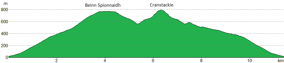
Route profile »
Weather forecasts »
| Regional | MWIS - Northwest Highlands |
| Peak specific | Mountain Forecast.com Met Office YR.no |
| Seasonal | Midge forecast |
Alternative and nearby routes »
Cranstackie and Beinn Spionnaidh from Carbreck | |
|
Hillwalking route up Cranstackie and Beinn Spionnaidh from Carbreck following a track to climb grassy slopes to the rocky crests of the twin peaks. Peaks : 2 Corbetts
Ascent : 1050m (3440ft) Distance : 13km (8m) Time : 5hr* | |
Ben Hope from Strath More | |
|
Hillwalking route up Ben Hope via a path up its southern shoulder from Strath More. Alternatives include from Dùn Dornaigil broch or the north ridge scramble. Peaks : 1 Munro
Ascent : 915m (3000ft) Distance : 7km (4m) Time : 3:10hr* | |
Reay Forest Corbetts from Lone | |
|
Hillwalking route up Foinaven, Meall Hòrn and Arkle from Achfary. A demanding circular over three Reay Forest Corbetts on rough crests and complex terrain. Peaks : 3 Corbetts
Ascent : 2550m (8370ft) Distance : 31km (19m) Time : 12hr* | |
Foinaven and Arkle from Loch Stack | |
|
Hillwalking route up Foinaven and Arkle from Stack Lodge. Estate tracks give way to steep, rough ground leading to the narrow crests of these superb peaks. Peaks : 2 Corbetts
Ascent : 2175m (7140ft) Distance : 31km (19m) Time : 11:30hr* | |
* Times shown are estimates – see timing notes on the disclaimer page for more information.

