

Reay Forest Corbetts from Lone
Hillwalking route up Foinaven, Meall Hòrn and Arkle from Achfary. A demanding circular over three Reay Forest Corbetts on rough crests and complex terrain.
Route outline
| Corbetts | ||||
| Ascent | 2550m (8360ft) | |||
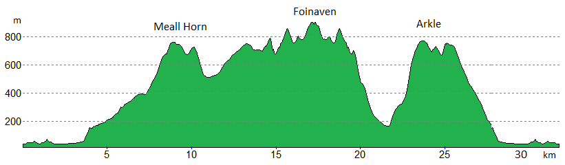
| Distance | 31km (19m) | |||
| Time | 12:00hr | |||
| Start/finish | Achfary, Loch Stack Grid Ref : NC297402 | |||
| Terrain |
| |||
| Nav |
| |||
| Effort |
| |||
| Scenery |
| |||


This is a spectacular outing taking in the three Corbett peaks of Meall Horn, Arkle and mighty Foinaven in a circular route.
The route starts from near Achfary at the southern end of Loch Stack and initially follows a private road. The road becomes a track as it heads into the Reay Forest wilderness, which higher up if left behind and where terrain is pathless for most of the route over the summits and mountain crests. This is a challenging route where navigation skills and route choice will be tested.
Show map

Route description
1. Getting to Achfary

Ruin at Lone, Arkle beyond
In the far north of Scotland, Foinaven, Arkle and Meall Hòrn lie in the vast area of Reay Forest over looking the A838 travelling from Lairg to Laxford Bridge and Rhiconich. A few miles south-east of Laxford Bridge is Loch Stack and at its southern end, just north of the hamlet of Achfary, there is a private road heading northwards. This is where the route begins and there is ample parking at the junction of this road or by the bridge over the inflow to Loch Stack.
2. Meall Horn

Meall Horn from the track above the Allt Horn
Leaving the public road behind, head over the bridge on the private road, then north up to the house at Airdachuilinn  .
The road is tarred to this house, thereafter a track leads to the sheds and bridge over the Allt Hòrn at Lone
.
The road is tarred to this house, thereafter a track leads to the sheds and bridge over the Allt Hòrn at Lone  .
.
Cross the bridge and shortly thereafter the track comes to a junction - take the left fork and continue over a couple more bridges to a forested area guarded by two remarkable rocks  either side of the track.
Continue following the track as it traces a route above the Allt Hòrn for roughly 3km to just below the 400m contour  . Leave the track here and aim eastwards, initially losing a little height, bounding over peat hags and through heather. Heather ground cover gradually is replaced by grass as height is gained and any rocky outcrops are easily avoided.
Meall Hòrn's summit  is reached on which a decent cairn rests from where fine views can be savoured.
3. Ganu Mor, Foinaven

Small shelter at top of Cadha na Beucaich screes
Foinaven has an array of summits and ridges with the highest point being just about as far away as possible from Meall Hòrn. There's a right mix of terrain ahead awaiting !
From Meall Hòrn's summit, turn north-west and head along the hill's crest its northern high point, Creagan Meall Hòrn  . From this minor summit, aim west-north-west and you should be able to pick a route down to Bealach Hòrn avoiding crags - the going is steep and loose, but not overly difficult.
Cross the bealach and the track  , then travel northwards for 2km, picking for a grassy route amongst the slabs and boulders.
Contour around Creag Dionard  (minor summit at 778m and not marked on the OS maps) on its western side above the crags that drop to Còir a' Chruiteir. Now heading west, gain the minor summit (marked 808m)
  - do not be tempted to bypass this summit by its northern side !
We're now on Foinaven's ridge - there's some easy scrambling to enjoy on the way, but take care, particularly in wet conditions as the quartzite boulders can be very slippy.
Drop to Cadha na Beucaich, where there is a small stone shelter  , then up to A' Cheir Ghorm
  .
The spur heading north-east from A' Cheir Ghorm is most impressive and a scrambling route can be taken along it to drop down to Srath Dionard.
.
The spur heading north-east from A' Cheir Ghorm is most impressive and a scrambling route can be taken along it to drop down to Srath Dionard.

Approaching Foinaven from the south-east
 . The flat summit crest has two small cairns 150m apart, of which the western marks the top. Stunning views from here and on clear days you can see to Orkney !
Approaching Foinaven from the south-east
4. Arkle

Arkle from the Cadha na Beucaich screes
On Ganu Mor, about turn and retrace your steps along Foinaven's crests to the shelter on Cadha na Beucaich . Aiming south-west, begin to descend an excellent scree-run - if you enjoy scree-running, this is a pretty good 'un and will bring a smile to your face - for that a bit apprehensive, it's easier than it looks.
Gradually heather takes over from the scree and a line of old wooden posts  is met. Follow these posts travelling southwards to cross the track coming up from Lochstack Lodge, then aim for the eastern end of Loch na Tuadh
  .
.
Cross the burn flowing into the loch (some care required in spate), then keeping some crags ahead on your right, climb up heather clad slopes.
Ground levels out somewhat and Arkle's eastern shoulder comes into view, scree everywhere. Look to the left (south) side of this shoulder and the base  of a relatively easy route can be picked out. This line follows stunted heather for the most part, avoiding boulderfield, scree and rocky outcrops.

On Arkle's crest, Foinaven behind
 - tìme for a break on the small cairn that sits on the summit and take in the vast views.
On Arkle's crest, Foinaven behind
5. Return

Descending Arkle with view over Loch Stack to Ben Stack
Arkle's stunning crest curves around the scree filled coire of Am Bathaich below.
Immediately after leaving the summit, the ridge narrows and an amazing causeway of quartzite is crossed - some care required, particularly if damp ! This leads on to a minor summit  at 751m.
The ridge then broadens and a faint path is followed down to a col, then up to Arkle's southern summit  .
.
Now on a very broad and flat plateau of small stones, head southwards. After around 500m, the plateau is left behind and the final descent of the day begins. Using lines of grass between slabs and rocks, descend in a generally southwards direction, taking care not to be pulled too far to the right (west). Evenutally the track above the Allt Hòrn is picked up and retraced back to the roadside.
Route profile »
Maps and GPX downloads »


|
Download GPX of route |

|
Open route in OS Maps |
The map images above link to items on Amazon. A small commission is earned on any map purchased which helps fund the operating costs of this website.
Weather forecasts »
| Regional | MWIS - Northwest Highlands |
| Peak specific | Mountain Forecast.com Met Office YR.no |
| Seasonal | Midge forecast |
Alternative and nearby routes »
Foinaven and Arkle from Loch Stack | |

|
Hillwalking route up Foinaven and Arkle from Stack Lodge. Estate tracks give way to steep, rough ground leading to the narrow crests of these superb peaks. Peaks : 2 Corbetts
Ascent : 2175m (7140ft) Distance : 31km (19m) Time : 11:30hr |
Meallan Liath Coire Mhic Dhughaill and Meall Horn | |

|
Hillwalking route from Loch More over Meallan Liath Coire Mhic Dhughaill and Meall Horn, two fine Corbetts in the remote Reay Forest. Peaks : 2 Corbetts, 1 Fiona
Ascent : 1600m (5250ft) Distance : 22km (14m) Time : 8:10hr |
Ben Hee from Loch Merkland | |

|
Hillwalking route up Ben Hee from West Merkland. A direct but rough line over pathless, bouldery terrain gains this domed hill above Loch Merkland. Peaks : 1 Corbett
Ascent : 850m (2790ft) Distance : 14km (9m) Time : 4:55hr |
Cranstackie and Beinn Spionnaidh from Carbreck | |

|
Hillwalking route up Cranstackie and Beinn Spionnaidh from Carbreck following a track to climb grassy slopes to the rocky crests of the twin peaks. Peaks : 2 Corbetts
Ascent : 1050m (3440ft) Distance : 13km (8m) Time : 5hr |
Ben Stack from Achfary | |

|
Hillwalking route up Ben Stack from Achfary at the southern end of Loch Stack with option of alternative start from Lochstack Lodge. Ascent : 710m (2330ft)
Distance : 8km (5m) Time : 3:10hr |


