
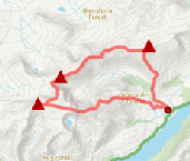
Gairbheinn and Meall na h-Aisre
Hillwalking route over Gairbheinn and Meall na h-Aisre - the Corbetts on the moorland east of Corrieyairack Pass and above the upper Spey.
Route outline
| Corbetts | ||||
| Ascent | 900m (2950ft) | |||
| Distance | 21km (13m) | |||
| Time | 6:45hr | |||
| Start/finish | Melgarve, Strathspey Grid Ref : NN464959 | |||
| Terrain |
| |||
| Nav |
| |||
| Effort |
| |||
| Scenery |
| |||


In the western Monadhliath the Corrieyairack Pass divides the high moorland. The northern side of the pass has several hills, two of which, Gairbeinn and Meall na h-Aisre, are high enough with sufficient prominence to have Corbett status. Corrieyairack Hill, which is immediately above the pass and used to have a height identical to Gairbeinn, was recently given a revised height of 892m and therefore with insufficient prominence from its neighbour, lost its place on the list of Corbetts.
The old Wade Military Road crosses the pass into the Great Glen and this can be driven along to Melgarve at the foot of Gairbeinn. Terrain is of deer-grass and bracken lower down with grass-covered slopes leading to moorland higher up that is pitted with lochans and marshy ground. Lines of old fences aid otherwise tricky navigation along Gairbeinn and some the way to Meall na h-Aisre, from where a track enables an easy (if rather ugly) descent.
Show map
Route description
1. Getting to Garva Bridge and Melgarve

Road end at Melgarve
West of Newtonmore and north of Dalwhinnie, the A86 and A889 meet just south of the River Spey, where nearby is the village of Laggan.
In Laggan village, a single track road heads westwards up Strathspey tracing the line of an old military road - follow this for 3km, through a farm on the way, to a sharp turn just after the entrance to Coul Farm.
The road then crosses the River Spey via a bridge and travels to the south of the Spey Dam and along the southern shore of its reservoir to end up by Garva Bridge. This bridge is marked on OS maps as the end of the public road, but in fact the road continues for a further 5km where it comes to an abrupt end by a small bridge over the Allt Feith a' Mhoraire. There is roadside parking around here for a few cars and beyond bridge are the disused buildings of Melgarve.
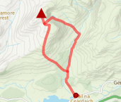
2. Gairbeinn

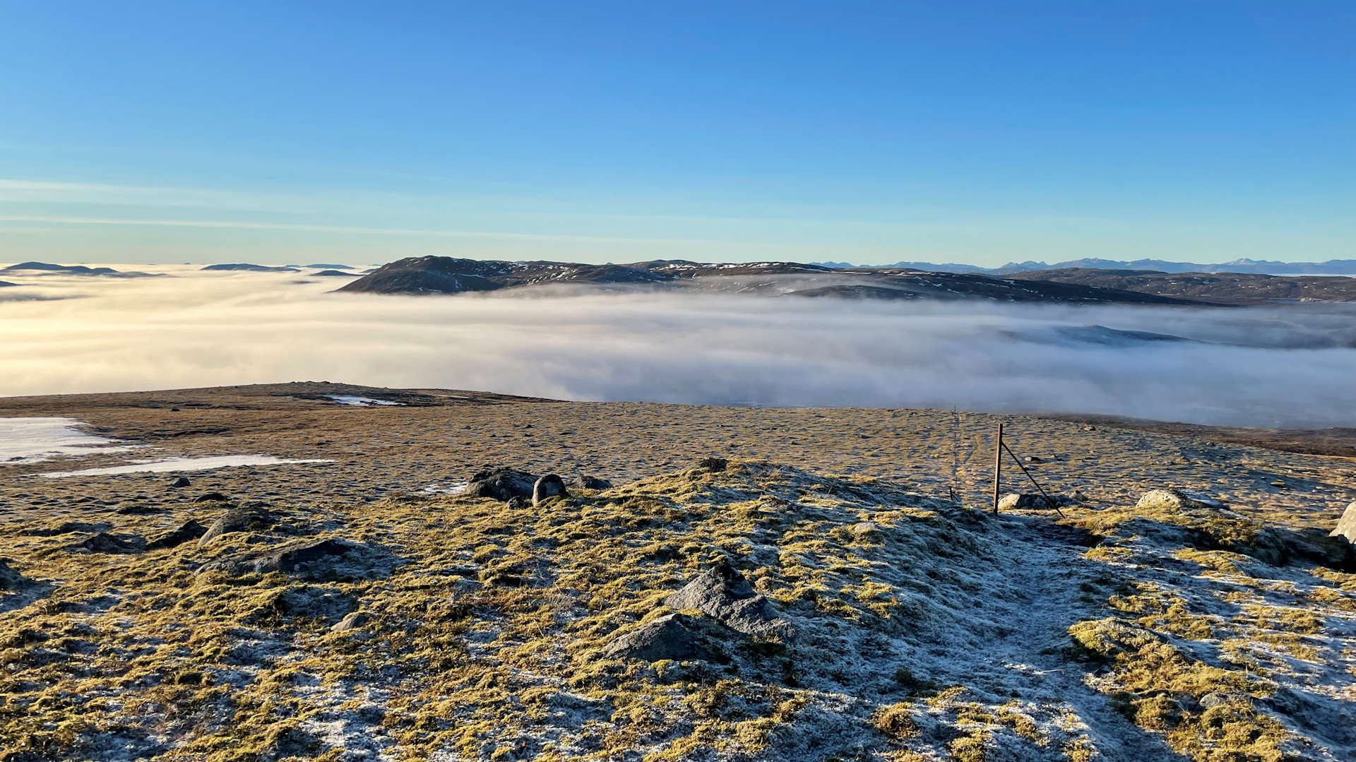
Looking through a fogbow to Gairbeinn from the Caochan Ban
From the bridge over the Allt Feith a' Mhoraire, head westwards on the Military Road and after around 500m meet with Melgarve Bothy  by the top of a track that leads down to other buildings at Melgarve.
A bit further along the Military Road, the Caochan Ban, a burn descending down from Gairbeinn, is met  . Leave the Military Road at this point and follow the east bank of Caochan Bàn uphill.
Occasional ATV tracks can be found, but in general a gentle slog up grass covered and pathless slopes leads uphill. Higher up at around 550m, the burn disappears into the ground, from where aim due north uphill.
Upon reaching Gairbeinn's south-west crest, turn north-east following wide grassy stretches broken occasionally with sections of rocks and crags. Gairbeinn's summit  is reached, marked by a cairn.
3. Meall na h-Aisre

On Meall na h-Aisre's summit looking to Geal Charn
From Gairbeinn's summit, head north-east along the hill's crest. A short distance from the summit you'll meet up with two lines of fence-posts running parallel, simply follow these for around 2km along Gairbeinn's undulating crest to its north-eastern summit  (spot height of 870m). Wind turbines spoil the view ahead !
Continue further along Gairbeinn's crest for perhaps a further 500m, then turn eastwards dropping around 50m or so before following fence-posts up a slight rise. Lochan Iain  can been seen ahead - hike over undulating grass and heather-clad terrain to the lochan's southern bank. Another lochan
  is now ahead, again aim for this one's southern bank. Finally a third lochan, Dubh Lochan
  is ahead, this tìme aim for the outflow at the northern end of the lochan.
Upon reaching Dubh Lochan, terrain becomes rougher with deep heather needing crossed, but after a short distance, the goal of Meall na h-Aisre and its summit are viewed ahead. Take a bearing of due-east and begin hiking, dropping slightly to cross a burn (the Allt Coire Iain Oig  ) on the way.
The final climb up Meall na h-Aisre begins, again over undulating pathless ground, though not for long, as a bulldozed track  is met and followed north-eastwards to its end
  . Continue for a further 100m or so aiming north-east and you'll meet up with a line of old fence-posts
  - turn right (east) and follow the line of posts up grassy terrain to Meall na h-Aisre's summit
  with its conical trig point.
4. Return

Beginning the descent down the track towards Garve Bridge
If you've had to navigate through mist to reach Meall na h-Aisre's summit, you'll be glad to know what remains is a straightforward hike on a track.
Retrace your steps aside the line of old posts to the top of the bulldozed track . Follow the track downhill to cross the Allt Coire Iain Oig  again and meet up with Sherramore's forest plantation
  . The track swings south-west, climbs slightly, crosses the Allt Gilbe
  , then turns southwards.
Further on, another track  is crossed and the track comes to an end by the entrance to an electric sub-station
  - leave the track and head over soggy ground around the sub-station's fence to meet up with the Military Road
  around 2km west of Garve Bridge.
The day is then rounded off with a pleasant walk along the road back to Melgarve.
Route profile »

Maps and GPX downloads »


|
Download GPX of route |

|
Open route in OS Maps |
The map images above link to items on Amazon. A small commission is earned on any map purchased which helps fund the operating costs of this website.
Weather forecasts »
| Regional | MWIS - Western Highlands |
| Peak specific | Mountain Forecast.com Met Office YR.no |
| Seasonal | SAIS - Creag Meagaidh Midge forecast |
Alternative and nearby routes »
Càrn a' Chuilinn from Glen Doe | |

|
Biking through Glen Doe up hydro roads into the Monadhliath, leaves a short distance on foot to bag the summit of Càrn a' Chuilinn. Peaks : 1 Corbett
Ascent : 735m (2410ft) Distance : 20km (12m) Time : 2:45hr |
Creag Meagaidh and neighbouring Munros | |
|
Circular hillwalking route up Creag Meagaidh via Càrn Liath and Stob Poite Coire Ardair, returning down the skyline or through ‘The Window’. Peaks : 3 Munros
Ascent : 1200m (3940ft) Distance : 19km (12m) Time : 6:45hr |
Geal Chàrn from Spey Dam | |
|
Hillwalking route up Geal Chàrn at the western end of the Monadh Liath. Gentle slopes hide odd landforms and interest off the direct line. Peaks : 1 Corbett
Ascent : 740m (2430ft) Distance : 15km (9m) Time : 4:45hr |
Black Craig and Creag Ruadh from Feagour | |

|
Hillwalking route from Feagour through Black Wood to Black Craig and Creag Ruadh, a heather crest to a trig point summit with fine views. Peaks : 1 Fiona
Ascent : 440m (1440ft) Distance : 7km (4m) Time : 2:30hr |
Glen Roy West | |

|
Hillwalking route up Corbetts and Grahams north and west of Glen Roy. A long round from Leana Mòr to Beinn Iaruinn and the Càrn Deargs above the glen. Peaks : 3 Corbetts, option of 1 Fiona
Ascent : 1410m (4630ft) Distance : 23km (14m) Time : 8:5hr |


