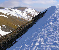
Gairbeinn
Gairbeinn is a long ridged and grass-covered hill to the east of the ancient Corrieyairack Pass.
Gairbeinn
| Height | 896m |
| Prominence | 211m |
| Meaning | rough mountain |
| Lists | Corbetts (C30) |
| Location | Glen Doe and Corrieyairack Pass, Monadh Liath to Glen Roy |
| Grid Ref | NN460985 |
| Lat/Lon | 57.05198, -4.53968 |
Corrieyairack Pass above the upper reaches of the River Spey, is an ancient pass on a drove route and has an Old Military Road crossing through it. To the east of this pass is Gairbeinn, a long ridged and grass-covered hill with its highest point just under Munro height.
The most obvious choice of route would be from the Old Military Road running alongside the River Spey, from where a quick hike up grassy slopes would bag this Corbett. Once on the summit, most Corbett-baggers in the past would have continued westwards to bag Corrieyairack Hill, which would have made a delightful circular route. However Corrieyairack Hill, which used to have a height identical to its Corbett neighbour at 896m, lost its place on the list of Corbetts after recent re-measurement found it to be the lower of the two.
Taking in Meall na h-Aisre to the east of Gairbeinn also makes for a fine circular route with fairly challenging navigation should mist be down. There is a fair bit of man-made intrusion to northerly views with wind turbines and hydro schemes, though this is offset by the ease of access enabled by the track bulldozed from the Spey to near to Meall na h-Aisre's summit.
Routes up Gairbeinn
Gairbheinn and Meall na h-Aisre | |
|
Hillwalking route over Gairbheinn and Meall na h-Aisre - the Corbetts on the moorland east of Corrieyairack Pass and above the upper Spey. Peaks : 2 Corbetts
Ascent : 900m (2950ft) Distance : 21km (13m) Time : 6:45hr | |
Nearby hills and mountains


