
Kintail's Big 9
Kintail's Brother and Sisters with Beinn Fhada and A' Ghlas Bheinn are the Munros surrounding Gleann Lichd and can be bagged in one epic circular hiking route.
Route outline
| Munros | ||||
| Ascent | 4115m (13500ft) | |||
| Distance | 41km (26m) | |||
| Time | 17:05hr | |||
| Start/finish | Kintail Outdoor Centre, Morvich Grid Ref : NG960211 | |||
| Terrain |
| |||
| Nav |
| |||
| Effort |
| |||
| Scenery |
| |||


A challenging circular route starting from the head of Loch Duich taking in all nine Munros that overlook Kintail and Strath Croe.
For the most part, this epic hillwalking route follows paths along mountain crests and ridges making for fairly straightforward navigation. The drop from Beinn Fhada to Fionngleann and subsequent rise to Ciste Duibhe is the most significant re-ascent on the route and with Camban Bothy close by, this is possibly the preferred point to split the route if needed.
This demanding hiking route can be split into three shorter ones, more details of which are in 'Alternative and nearby routes' below.
Show map

Route description
1. Getting to Morvich

Bridge over the Abhainn Chonaig
The A87 travels from Invergarry in the Great Glen, north west onto Kyle of Lochalsh and the Isle of Skye. As it descends through Glen Shiel and meets with the head of Loch Duich, the road turns north-east.
As the road approaches a causeway over an inlet at the western end of Strath Croe, there is an unclassified road marked with a sign pointing to Morvich. Turn onto this road and follow it for around 2km to where another junction is marked pointing to the NTS Kintail Outdoor Centre.
Turn up the side road, head to the outdoor centre and park in the large designated parking area by some buildings and information boards. Overnight parking is not permitted here.
There are some more spots to park further along the road, though these are rather limited to verge sides.
2. A' Ghlas-bheinn

Through Strath Croe, A' Ghlas-bheinn ahead
Leave the outdoor centre and follow the public road to its end then cross the bridge over the River Croe. After passing a side-road on your right, take a path marked with a sign showing the way to Glomach Falls.
This rough path crosses through a field and heads through the first of many gates and into woodland. The path wanders alongside the Abhainn Chonaig, travels out of the woodland into a field of grass to arrive at a split in the path by a wooden post marking way to the 'Falls' .
By the post, head left and follow a path into woodland to cross the Abhainn Chonaig via a bridge  . On the northern bank of the river, head out of the woodland and turn right on track through a field, passing an old ruined cottage, to reach a gate in a deer fence.
Through the gate, turn right on a forestry track, cross a bridge and follow the track as it heads into dense spruce plantation where it turns north-east. The forestry track turns sharply south-east and is followed to a gate in a deer-fence at the edge of forest  (2024 update : gate nailed shut, but can still be crossed over) .
Out of the forest, turn left and trace the fence enclosing the forest directly uphill. A track is crossed and, at around a height of 300m, the top of the forest is reached, enclosed by the deer-fence.
Having clambered over the fence, it's onto open hillside on one of A' Ghlas-bheinn's west facing shoulders to hike up a steep, grass-covered hillside. After gaining around 350m of height since leaving the fence above the forest, the ascent begins to level and a wide grass-covered expanse is crossed while aiming eastwards.

Summit of A' Ghlas-bheinn, looking to Ceathreamhnan
 on which a rather untidy cairn stands and from where stunning all-round views can be savoured.
Summit of A' Ghlas-bheinn, looking to Ceathreamhnan
3. Beinn Fhada

Bealach an Sgairne
From A' Ghlas-bheinn's summit, pick up a path and follow it southwards along the hill's grass-covered crest. Descending down a gentle gradient, some height is lost and the path comes to drop, where it then swings left (east) and drops to flat area.
Travelling over undulating ground, the path then passes a lochan (with Beinn Sgritheall beautifully framed in the distance to the west) and drops to a substantial cairn on the top of Bealach an Sgairne  - the narrow break between A' Ghlas-bheinn and Meall a' Bhealaich.
Head west from the cairn and follow a stalkers path through the gap, losing a little height to meet a little cairn by junction in the path  .
.
After taking the left branch, this path quickly begins to climb uphill and heads into Coire an Sgairne. Upon gaining the base of steeper ground in the coire, the stalkers path turns eastwards, then zig-zags up to meet a cairn  on the crest of Beinn Fhada's northern shoulder.
Once on the crest of this shoulder, the path turns southwards, gains a little height and begins to trace the upper edge of Coire an Sgairne. When the path meets with a burn, leave it and aim south-east up a wide grass-covered, and sometimes soggy, hillside.

On the path in Coire an Sgairne
 is reached. Spectacular views all round !
On the path in Coire an Sgairne
4. Ciste Duibhe

Heading along Beinn Fhada's eastern shoulder, looking back to its summit
From the trig-point on Beinn Fhada's summit, follow a path initially south-west-south, turning gradually eastwards as it follows the crest of the hill above Coire Toll a' Mhadaidh. With a little ascent, the minor summit of Sgùrr a' Dubh Doire  is reached.
Follow the crest of Sgùrr a' Dubh Doire eastwards until ground start to drop steeply, where turn south-east and drop 600m down steep, pathless, but easy and grass-covered terrain to cross the path of the 'Affric-Kintail Way' and reach the Allt Cam-ban  below in Fionngleann.
If hiking this route over two days, Camban bothy is just a short distance to the north-east along the 'Affric-Kintail Way' path.
Continuing onwards towards Ciste Duibhe, cross the Allt Cam-ban, then head directly up the hillside ahead. There are no paths to follow and terrain can be rather soggy in patches lower down. Higher up, ground narrows, steepens and forms the north-western shoulder of Ciste Dhubh.

Ciste Duibhe from the Allt Cam-ban
 can be seen ahead. A small cairn rests on Ciste Dhubh's top which is an intriguing place with some very sharp drops on its eastern side.
Ciste Duibhe from the Allt Cam-ban
5. Aonach Meadhoin

Hiking up slopes of Sgùrr an Fhuarail, looking back to Ciste Dhubh
Head south from Ciste Dhubh's small cairn on a very obvious path downhill, bypassing the minor summit of An Cnapach. The crest of the hill turns south-east with the path becoming fainter as it descends to the burn  flowing from the lochan on Bealach a' Choinich - an ideal spot to fill waterbottles, as there are no other burns on the remaining route.
Aim up wet grass-covered ground with path gradually forming and heading for Sgùrr an Fhuarail's northern arm. The going underfoot becomes drier further up as the wide hillside narrows into a ridge of sortsto reach the cairn sitting on Sgùrr an Fhuarail's boulder covered top  .
.

On way from Sgùrr an Fhuarail to Aonach Meadhoin
 where a large untidy cairn rests.
On way from Sgùrr an Fhuarail to Aonach Meadhoin
6. Sgùrr a' Bhealaich Dheirg

Approaching col between Aonach Meadhoin and Sgùrr a' Bhealaich Dheirg
Leave Aonach Meadhoin's summit heading west-south-west and cross its broad crest. As height is lost, the crest narrows to form a grassy ridge with a path tracing along its spine above Coire nan Eun. There are a couple of little rocky sections encountered on route which aren't difficult to cross or by-pass.
The ridge widens and the path travels down to the bealach  below Sgùrr a Bhealaich Dheirg. A wide grass-covered and gently rising slope leads from this col up onto the crest running along the top of Sgùrr a' Bhealaich Dheirg .

On Sgùrr a' Bhealaich Dheirg's large cairn
 is reached.
On Sgùrr a' Bhealaich Dheirg's large cairn
7. Saileag

Saileag from west of Sgùrr a' Bhealaich Dheirg
Retrace your steps back along the ridge detour to the dyke, then initially heading westwards cross a grass-covered crest above Glas-choire reach to a minor summit  .
.
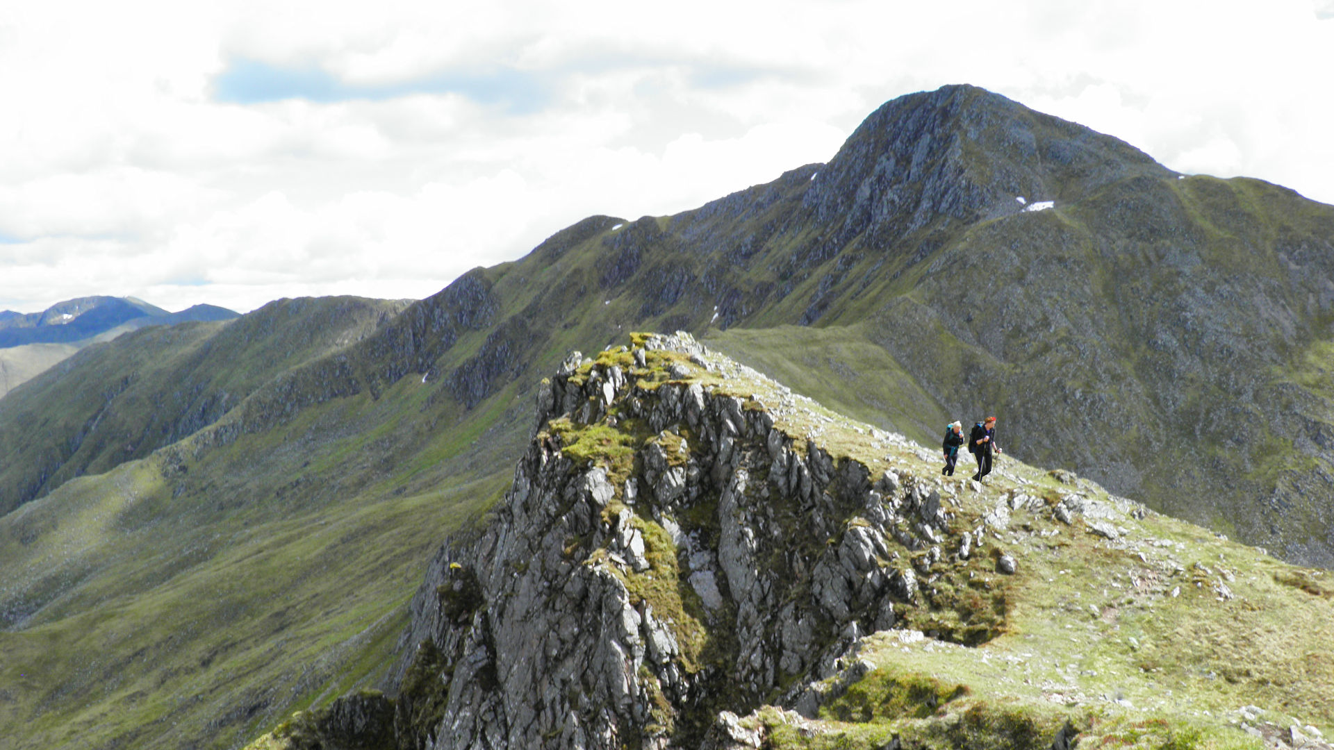
Turn west to lose height on bouldery ground, then follow grass-covered crests to meet with a little rocky lump. This lump appears to block progress - it is easily scrambled up to reach to top of a minor top just above the 900m contour. Thereafter, the path is followed above Am Fraoch-choire over an undulating crest to reach the bealach below Saileag.

Path crossing col on way to Saileag
 .
.Path crossing col on way to Saileag
8. Sgùrr nan Spàinteach and Sgùrr na Ciste Duibhe

Descending the western crest of Saileag
Beyond Saileag, the path takes a straightforward route downhill over grass covered ground, south-west for around 1km to drop to Bealach an Lapain  .
.
If you're short of water, there are a few springs in the coire to the north, but you'll need to descend 20-30m to reach them depending on the amount of recent rainfall.
Leaving the Bealach an Lapain behind, follow the ridgeline ahead westwards. The route climbs gradually over the next 2km, encountering a few rises and false summits to land on the summit of Sgùrr nan Spàinteach  .
.
West of Sgùrr nan Spainteach, a drop down boulder-covered ground is made without any real difficulties until some steep rocky ground just above the col between Sgùrr nan Spàinteach and Sgùrr na Ciste Duibhe is reached. In dry conditions and with a little scrambling, this is fairly straighforward to descend.
The bealach between Sgùrr na Ciste Duibhe and Sgùrr nan Spàinteach is reached and is a slightly confusing place where a grassy hollow sits below two minor shoulders. Along each shoulder is a path - either path will do as they converge further along the crest to form one path. This path then veers right to the north-west, then turns back to zig-zag up some scree onto some boulders, which can hold snow into late spring.

Looking back to Sgùrr nan Spàinteach while nearing the summit of Sgùrr na Ciste Duibhe
 is reached where a large cairn sits.
Looking back to Sgùrr nan Spàinteach while nearing the summit of Sgùrr na Ciste Duibhe
9. Sgùrr na Carnach

Sgùrr na Carnach from Sgùrr na Ciste Duibhe
From Sgùrr na Ciste Duibhe's large cairn, head initially west on a faint path crossing through patches of stoney ground and boulderfield on the mountain's crest. The crest turns north-west and becomes more grass-covered at it drops to Bealach na Craoibhe, the col below Sgùrr na Carnach  .
.
From the bealach, the path heads slightly right (east) of the crest ahead, then follows an easy line, initially on grass, then stone, to zig-zag its way back onto the crest of Sgùrr na Carnach's southern shoulder, then to it's summit  .
.

Climbing Sgùrr na Carnach, Sgùrr na Ciste Duibhe behind
Climbing Sgùrr na Carnach, Sgùrr na Ciste Duibhe behind
10. Sgùrr Fhuaran

Descending Sgùrr na Carnach, Sgùrr Fhuaran ahead
Leaving Sgùrr na Carnach's summit, head northwards and suddenly the ground ahead drops steeply. The path is found, well-trodden and obvious, but occasionally there are some short rocky sections in descent. Though the scrambling involved to pass these sections is easy and for the most part quite protected, some care is required.
Having passed Sgùrr na Carnach's steep north-facing ground, the path crosses more level and grass-covered ground to reach Bealach na Carnach  , the col below Sgùrr Fhuaran.
Above Bealach na Carnach, the path continues uphill as it tries to find an easy line between boulders and scree. The path begins to branch out in various directions as it progresses uphill - take any line that suits - I've found it slightly easier keeping to the left branches, whereas paths on the right tend to end with an occasional scramble over loose rock or scree.

Nearing Sgùrr Fhuaran's summit, looking back to Sgùrr na Carnach
 where a small cairn rests.
Nearing Sgùrr Fhuaran's summit, looking back to Sgùrr na Carnach
11. Sgùrr nan Saighead and return to Morvich

Sgùrr nan Saighead from the descent on Sgùrr Fhuaran
Head north-west from Sgùrr Fhuaran's summit following the obvious path as it twist and turns to lose around 100m of height. The ground levels a little and reaches a grassy bank.
Ignore the faint path heading off left and keep to the more obvious path as it follows the crest of Sgùrr Fhuaran's northern spur dropping to Bealach Buidhe. Ahead is Sgùrr nan Saighead  , a grass-covered pyramid with spectacular cliffs on its east face. This fine peak is worth summiting, but as it is not a Munro, a by-pass path has developed on the grassy slopes of its south-western face.
Beyond Sgùrr nan Saighead the path follows the ridge-line of the Five Sisters and heads north-west to cross the minor summit of Beinn Bhuidhe, before turning north-east to drop to the bealach at the head of Coire na Criche  .
.
From the bealach, head down a path into Coire na Criche as it traces the northern bank of the Allt a' Chruinn. Lower down this path becomes more maintained as it curves around some woodland surrounding a waterfall, crosses a stile and drops to reach the head of a head of track  by a water supply. The track drops to the narrow road by the head of Loch Duich, where all that remains is a walk of just over 1km back to Morvich.
Route profile »

Maps and GPX downloads »


|
Download GPX of route |

|
Open route in OS Maps |
The map images above link to items on Amazon. A small commission is earned on any map purchased which helps fund the operating costs of this website.
Weather forecasts »
| Regional | MWIS - Northwest Highlands |
| Peak specific | Mountain Forecast.com Met Office YR.no |
| Seasonal | SAIS - Lochaber Midge forecast |
Alternative and nearby routes »
A' Ghlas-bheinn and Beinn Fhada | |

|
In Kintail, a hike up Strath Croe leads to the two Munros of A' Ghlas-bheinn and Beinn Fhada which stand either side of the narrow gap of Bealach an Sgairne. Peaks : 2 Munros
Ascent : 1500m (4920ft) Distance : 20km (12m) Time : 8:45hr |
Sisters of Kintail | |

|
From the Battle of Glen Shiel site, a linear hillwalking route leads along ridges and Munros that form the Five Sisters of Kintail to drop to Loch Duich. Peaks : 3 Munros
Ascent : 1330m (4360ft) Distance : 13km (8m) Time : 5:30hr |
Brothers of Kintail | |

|
Above Glen Shiel and the Cluanie Inn, well defined paths travel along mountain crests and four Munros, of which Sgùrr a' Bhealaich Dheirg is the highest. Peaks : 4 Munros, 1 Corbett
Ascent : 1650m (5410ft) Distance : 16km (10m) Time : 6:45hr |
Sgùrr Gaorsaic and Falls of Glomach | |

|
A hike into Kintail on well-defined paths leads to a circular route around A' Ghlas-bheinn, bags the Corbett Sgùrr Gaorsaic and visits the Falls of Glomach. Peaks : 1 Corbett
Ascent : 1250m (4100ft) Distance : 23km (14m) Time : 7:50hr |
Sgùrr an Airgid from Morvich | |

|
An estate track and rough path lead up from the head of Loch Duich to the summit of Sgùrr an Airgid, a quiet spot with sensational views. Peaks : 1 Corbett
Ascent : 830m (2720ft) Distance : 9km (6m) Time : 3:35hr |


