

Leum Uilleim from Corrour
A circular hillwalking route over moorland climbs the Corbett Leum Uilleim from remote Corrour Halt on the West Highland Line station.
Route outline
| Corbetts | ||||
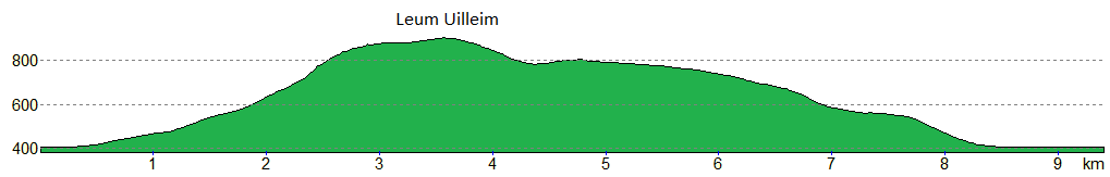
| Ascent | 550m (1800ft) | |||
| Distance | 10km (6m) | |||
| Time | 3:25hr* | |||
| Start/finish | Corrour Halt, Loch Ossian Grid Ref : NN356664 | |||
| Terrain |
| |||
| Nav |
| |||
| Effort |
| |||
| Scenery |
| |||


The hillwalk described here begins from remote Corrour Halt on the West Highland Line. The station cannot be reached by road, the nearest road-accessible stations being Rannoch to the south and Tulloch to the north.
This circular route climbs across moorland to reach Leum Uilleim’s summit. Most of the route follows ATV tracks, though terrain on the hill’s eastern shoulder becomes rougher above around 500m where only faint traces of path can be found.
Route map

Route description
1. Getting to Corrour Halt

Train at Corrour Halt
Corrour Halt is the country's highest train station and is on the West Highland Line which travels from Glasgow to Fort William and onto Mallaig. Corrour Halt can't be accessed by road, the nearest stations that can are Rannoch to the south and Tulloch to the north.
Should you not wish to travel to Corrour by train, there are fine estate tracks that can be cycled or walked on instead. One travels for the best part of 30km from Moy on Loch Laggan, another slightly shorter route but with more climbing heads in from Loch Eigheach near Rannoch Station.
Open from April to October is Corrour Station House Restaurant - worth making a reservation if you fancy something to eat after your time on the hills.
The SYHA Ossian Hostel is a lovely place to stay if you fancy spending more time here.
2. Leum Uilleim

Soggy ground below Leum Uilleim
From Corrour Halt, cross over the railway line at northern end of the station and head through a gate.
By a right-of-way signpost which indicates some longer routes, initially follow some obvious ATV tracks heading south-west.
Depending on the season and recent weather, ground underfoot can be a bit soggy, but persist following the tracks as they gently climb around 150m over 1.5km.
Where the tracks turn south  , leave them and you should be able to see evidence of a faint path heading directly up the crest of Leum Uilleum's eastern shoulder, Sròn an Lagain Ghaibh.
The path comes and goes as it makes its way onto Leum Uilleum's summit plateau, from where a short walk leads to the large cairn  on the top.

Summit of Leum Uilleim with Beinn na Lap beyond
Summit of Leum Uilleim with Beinn na Lap beyond
3. Return to Corrour Halt

The tracks on Leum Uilleim's northern shoulder
The shortest return is to about-turn and re-trace your steps back to Corrour Halt.
An finer alternative begins by heading west from the summit down a predominantly grass-covered slope, with occasional boulderfield, to the bealach at the head of Coir' a' Bhric Beac  .
.
The minor top of Beinn a' Bhric  overlooks this bealach and only a short detour is needed to reach its summit for more fine views.
At the bealach more ATV tracks can be picked up. These aim northwards around Beinn a' Bhric, join with another set coming from the south-west, then descend Leum Uilleum's broad northern shoulder, Tom an Eòin. OS maps give the wrong impression of a track and I couldn't see the cairn marked at the 780m contour !

At bottom of ATV tracks looking back up to Leum Uilleim
 , the ATV tracks meet with a decent track which is followed for around 1km back to Corrour Halt.
At bottom of ATV tracks looking back up to Leum Uilleim
Maps and GPX downloads »


Route profile »
Weather forecasts »
| Regional | MWIS - Western Highlands |
| Peak specific | Mountain Forecast.com Met Office YR.no |
| Seasonal | SAIS - Creag Meagaidh Midge forecast |
Alternative and nearby routes »
Munros around Loch Ossian | |
|
Circular hike over Munros around Loch Ossian — Beinn na Lap, Sgòr Gaibhre and Càrn Dearg — best reached by train to remote Corrour Halt. Peaks : 3 Munros
Ascent : 1550m (5090ft) Distance : 26km (16m) Time : 9hr* | |
Beinn na Lap to Chnò Dearg route from Laggan | |
|
Bike-n-hike from Laggan over remote Munros east of Loch Treig, combining Beinn na Lap, Stob Coire Sgriodain and Chnò Dearg for a big outing. Peaks : 3 Munros
Ascent : 1650m (5410ft) Distance : 42km (26m) Time : 8hr* | |
Chnò Dearg and Stob Coire Sgriodain | |
|
Hillwalking route from Fersit over Chnò Dearg and Stob Coire Sgriodain, two contrasting Munros linked by a vast grass plateau east of Loch Treig. Peaks : 2 Munros
Ascent : 1250m (4100ft) Distance : 16km (10m) Time : 6hr* | |
Stob an Aonaich Mhòir from Loch Rannoch | |
|
Biking and hiking route up Stob an Aonaich Mhòir from Loch Rannoch. Cycle a hydro road then hike just over 1km on grass and heather to the summit. Peaks : 1 Corbett
Ascent : 690m (2260ft) Distance : 30km (19m) Time : 3:10hr* | |
Easains from Fersit | |
|
Hillwalking route up the Easains from Fersit, climbing Stob Coire Easain and Stob a’ Choire Mheadhoin above Loch Treig, the “This Yin & That Yin”. Peaks : 2 Munros
Ascent : 1200m (3940ft) Distance : 15km (9m) Time : 6hr* | |
* Times shown are estimates – see timing notes on the disclaimer page for more information.

