
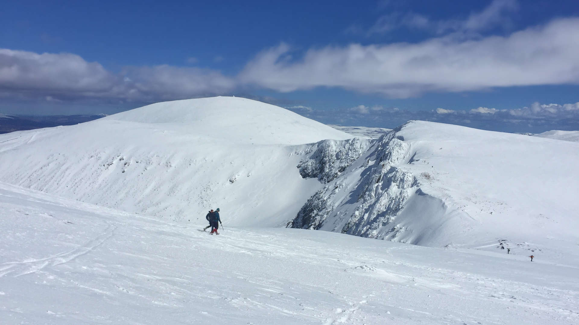
Cairngorm and Ben Macdui
Hillwalking route up Ben Macdui and Cairn Gorm with an optional relatively easy scramble on Fiacaill Ridge in good summer conditions.
Route outline
| Munros | ||||
| Ascent | 1000m (3280ft) | |||
| Distance | 17km (11m) | |||
| Time | 6:00hr | |||
| Start/finish | Cairngorm Mountain car-park Grid Ref : NH990059 | |||
| Terrain |
| |||
| Nav |
| |||
| Effort |
| |||
| Scenery |
| |||


The slopes leading up to the Munro summits begin from a height of around 650m above sea-level and are never too steep, so in clear summer conditions this is a straightforward route. Winter conditions change the situation dramatically, with some parts of the route holding snow into late spring. Snow-bunting can be seen all year round and often you'll spot reindeer !
For most of the route, terrain underfoot is on fine, well-maintained paths striking a way through stoney and bouldery ground. There are some wide grass covered plains between Stob Coire an t-Sneachda and Ben Macdui with arctic-like tundra higher up.
Away from paths, good navigation skills will be needed. Some of the route follows the rims of coires above huge drops down to hiddens lochans, with cornices can extending well beyond the edges in winter.
There are various alternatives and escape routes to be found, including an excellent rock-scrambling option descending Fiacaill Ridge - a Grade 1 summer rock-scramble with easy escape lines for those not wanting to stick to the crest.
If just aiming up Cairngorm, this is one of the easier Munro routes !
Show map

Route description
1. Getting to Cairngorm Mountain car-park

Cairngorm from the Day Lodge
On the south side of Aviemore, there is a roundabout, from where the road to Glenmore and Cairngorm Mountain begins. It's a journey of around 15km passing lovely Loch Morlich on the way.
There is a frequent bus service from Aviemore direct to Cairngorm Day Lodge.
To park in the Cairngorm Day Lodge car-park costs from £3 outwith the winter snowsports season.
During the winter snowsports season parking is free, however it may be very busy or even full, in which case parking in the lower Coire Ciste car-park is recommended - from where an approach to Cairngorm is made via Cnap Coire na Spreidhe (see section 6 below).
2. Cairngorm

On touring skis, skinning up Windy Ridge
From the large car-park head up on the track between the Day Lodge and Base Station. Immediately after passing under the funicular railway, take the path off left at where a sign points to the "Windy Ridge Path".
The path is well constructed and is quite steep to begin with, initially twisting and turning as it climbs aside the Day Lodge Piste.
The path turns eastwards away from the piste, with the incline easing a little. Higher up it crosses through a wooden snow-fence and over the M2 ski run while gradually turning southwards as it climbs Sròn an Aonaich.
Crossing back over the ski pistes, the Top Station and Ptarmigan Restaurant  are reached. Above this building, a well constructed path with a line of posts either side (linked together in summer with rope), begins the final climb towards Cairngorm's summit.
Once the final posts are passed, a series of cairns mark the route to the summit of Cairngorm  , where there is a large well constructed cairn with the Cairngorm Automatic Weather Station nearby.

Descending back to the Top Station with Meall a' Bhuachaillie ahead.
Descending back to the Top Station with Meall a' Bhuachaillie ahead.
3. Ben Macdui

Descending Cairngorm towards Stob Coire an t-Sneachda
To continue onwards to Ben Macdui, leave Cairngorm's cairn and weather station and head due west over bouldery ground.
A constructed path can be picked up and followed downhill, though this may not be to obvious as snow and ice take their toll on it.
The path drops down to level ground and bypasses 'Point 1141'  to reach a bealach above some airy drops into Coire an t-Sneachda below.
Uphill, the path can be traced through boulders onto the 'Munro Top' of Stob Coire an t-Sneachda  , a superb spot for taking in views ! In winter, the crags and cliffs are famed for their winter climbing routes.
Continue walking south-westwards following the rim of Coire an t-Sneachda and drop to the next bealach  above Coire Domhain.
To aim for Ben Macdui, turn left onto an obvious path and follow it southwards as it cuts through a grass-covered slope. The path turns south-west and travels for a further 1km to reach Lochan Buidhe  - a fine place to stop and take in the atmosphere.
Beyond the lochan, the path turns more southwards and after another 1km, leaves the grass-covered plateau and begins to climb on more stony tundra with patches of boulderfield.
A series for cairns  is met, aiding navigation on the approach to Ben Macdui, though the path is fairly clear most of the way.

Approaching Lochan Buidhe on the way to Ben Macdui
 has a large cairn, on top of which is a trig pillar, and a viewfinder nearby. Cairn Toul and Braeriach look spectacular from Ben Macdui, though due to Ben Macdui's vast flat large summit, a short wander from the summit will be needed to get the best views.
Approaching Lochan Buidhe on the way to Ben Macdui
4. Return to Cairngorm Mountain car-park

Cairns marking the return from Ben Macdui towards Cairn Lochan
To return, begin by retracing your steps northwards following the cairns heading back towards Lochan Buidhe .
Just before reaching the lochans, a small cairn marks a split in the path. Taking the path on the left, this runs parallel for a short distance then gradually turns north-west and begins to climb.
The path contours around the mass of Cairn Lochan  as it travels above steeps slopes that drop down to the Làirig Ghrù.
The path drops to a wide flat area  by the source of the burns heading down into Coire an Lochan and is joined by a path coming down from Cairn Lochan.

Walking out under the cliffs of Cairn Lochan
 and to travel back to the Day Lodge and Base Station.
Walking out under the cliffs of Cairn Lochan
5. Cairngorm's Northern Corries

Heading down Fiacaill Ridge
Seen from the shores of Loch Morlich, the rugged line of Cairngorm and the Northern Corries creates a dramatic backdrop.
While the long, gentle ascent over the Cairngorm plateau to Ben Macdui is a fine route, a shorter, more thrilling hike skirts the cliff edges above the Northern Corries. This alternative offers breathtaking views and a touch of excitement as you navigate this rugged terrain.
As in the route described above, follow the paths to the bealach above Coire Domhain. Here, veer away from the path heading south toward Ben Macdui and instead climb northwards on a less defined trail.
The trail soon splits, to the right a path leads to a short detour to the top of Fiacaill Coire an t-Sneachda  , to the left a path continues straight on, with the incline beginning to ease over a broad crest. Both paths merge on the approach to Cairn Lochan
  , a lofty perch above the sheer cliffs of Coire an Lochain.
Around the top of the cliffs on Cairn Lochan, continue in a generally westward direction while keeping a look out for more cairns. Once met, this line of cairns denote a path heading through boulderfield and downhill. The path drops to a wide damp area - the source of the burns heading down into Coire an Lochan - with the path crossing it via a series of stepping stones. After a little incline, the path merges with that coming from Ben Macdui, to follow back to the Day Lodge.
Escape Routes
The Northern Corries offer three distinct escape options should you need to descend early :
Point 1141: A prominent cairn marks the minor summit often referred to as just 'Point 1141' . From here, a well-constructed path descends along Fiacaill a' Choire Chais into Coire Cas. It drops to the Zig Zags piste and follows it briefly toward the Mid Station, where a preferred walker's path heads back to the Day Lodge.
The 'Goat Track':
From the bealach above Coire an t-Sneachda , the 'Goat Track' winds steeply down loose ground into the boulder-strewn basin of the coire's lochans  . North of the lochans, the terrain becomes more forgiving, with the path merging
  with the main path out of Coire an t-Sneachda. Note: In icy conditions, technical gear is essential for this route !

On the summit of Cairn Lochan looking northwards
. This ridge, often referred to as just 'Fiacaill Ridge', is classed as a Grade 1 summer rock-scramble. Though not overly exposed, the ridge demands care, with bypass options on loose scree to the west. The lower path leads through boulders and stony ground, reconnecting with the Ben Macdui route near the crossing of the Allt Coire an t-Sneachda .On the summit of Cairn Lochan looking northwards
6. Exploring the Munro Tops around Cairngorm and Ben Macdui

Bynack Mòr from the cairns just north of Cnap Coire na Spreidhe
The routes above guide hillwalkers to the Munros of Cairngorm and Ben Macdui, passing the 'Munro Tops' of Stob Coire an t-Sneachda and Cairn Lochan along the way. Beyond these, the area features three additional Munro Tops, each with unique features and easily accessible via short detours from the described routes.
Cnap Coire na Spreidhe
Located northeast of Cairngorm, Cnap Coire na Spreidhe could be reached as a detour, but an approach from the Coire Ciste car park is preferred.
From the car-park, follow a path eastwards and down a wooden boardwalk to the burn in the coire. Passing some fencing, aim uphill on a well-defined trail. The route passes above Creagan Dubh and Coire na Ciste, popular training grounds for Glenmore Lodge and other outdoor groups.
About 500m north of Cnap Coire na Spreidhe, a short detour eastward from paths reveals the 'El Alamein' refuge  constructed of metal frame and boulders. Continuing southwards from Cnap Coire na Spreidhe
  , a straightforward trek over bouldery terrain leads to the striking granite tors
  just east of Cairngorm's summit and then to the main summit itself.
Lurcher's Crag
Northwest of Cairn Lochan, Lurcher's Crag  is accessible via a 1km detour from the path leading out from Ben Macdui. To the north of this Munro Top lies the Chalamain Gap, a fascinating V-shaped rocky gorge formed by Ice Age meltwater. This unique feature can also be explored en route from Glenmore to the Làirig Ghrù.
Càrn Etchachan

Lurcher's Crag from the slopes of Cairn Lochan
 appears as a mere gentle rise. The detour to the summit of this Munro Top is around 2km with the effort rewarded with breathtaking views over Loch Avon and the surrounding peaks.
Lurcher's Crag from the slopes of Cairn Lochan
Route profile »

Maps and GPX downloads »



|
Download GPX of route |

|
Open route in OS Maps |
The map images above link to items on Amazon. A small commission is earned on any map purchased which helps fund the operating costs of this website.
Weather forecasts »
| Regional | MWIS - Cairngorms and Monadhliath |
| Peak specific | Mountain Forecast.com Met Office YR.no |
| Seasonal | SAIS - Northern Cairngorms Midge forecast |
Alternative and nearby routes »
Cairngorm 4000s | |

|
Circular hillwalking route over the Cairngorm 4000ers from Glenmore, including Ben Macdui, Braeriach, Cairn Toul, Sgòr an Lochain Uaine and Cairn Gorm. Peaks : 5 Munros
Ascent : 2250m (7380ft) Distance : 28km (17m) Time : 10:45hr |
Cairngorm Darkside from the north | |

|
Route up Ben Macdui and Beinn Mheadhoin from Cairn Gorm ski centre, visiting Loch Avon’s beaches and the famous Shelter Stone en route. Peaks : 4 Munros
Ascent : 1730m (5680ft) Distance : 27km (17m) Time : 9:40hr |
Meall a' Bhuachaille from Glenmore | |

|
Hillwalk from Glenmore via Ryvoan and the Green Lochan to Meall a' Bhuachaille, passing Ryvoan Bothy before a direct ascent on a decent path. Peaks : 1 Corbett
Ascent : 550m (1800ft) Distance : 9km (6m) Time : 3:15hr |
Bynack More and Creag Mhòr from Glenmore | |

|
Hillwalking route from Glenmore up Bynack Mòr and Creag Mhòr. A bike helps access these hills, where weird granite tors crown the summits. Peaks : 1 Munro, 1 Corbett
Ascent : 860m (2820ft) Distance : 22km (14m) Time : 5:30hr |
Bynack More and Creag Mhòr from Glenmore | |
|
|
Hillwalking route from Glenmore up Bynack Mòr and Creag Mhòr. A bike helps access these hills, where weird granite tors crown the summits. Peaks : 1 Munro, 1 Corbett
Ascent : 860m (2820ft) Distance : 22km (14m) Time : 5:30hr |


