
Bynack More and Creag Mhòr from Glenmore
Hillwalking route from Glenmore up Bynack Mòr and Creag Mhòr. A bike helps access these hills, where weird granite tors crown the summits.
Route outline
| Munros | ||||
| Corbetts | ||||
| Walk ascent | 760m (2490ft) | |||
| distance | 13km (8m) | |||
| time | 4:30hr | |||
| Bike ascent | 100m (320ft) | |||
| distance | 9km (6m) | |||
| time | 1:00hr | |||
| Start/finish | Glenmore Lodge Grid Ref : NH988095 | |||
| Terrain |
| |||
| Nav |
| |||
| Effort |
| |||
| Scenery |
| |||


This is the most popular route to Bynack More and begins from Glenmore from where a fine track heads up to Strath Nethy. A well-constructed path then leads up onto Bynack Mòr and its subsiduary top Bynack Beg. Apart from the final haul up Bynack More's northern side, gradients are gentle and away from the main paths, terrain is predominantly heather covered. There's a fair distance to cover to reach the Munro summit, but around half of this can easily be done on bike.
Winter is probably the best tìme to hike up Bynack More, snow and ice make for a more challenging day and crisp air allows vast views from the summit.
The nearby Corbett peak of Creag Mhòr can be climbed via a detour. This adds around an additional 3km of distance and 250m of ascent onto the figures above.
Show map

Route description
1. Getting to Glenmore Lodge
On the south side of Aviemore, there is a roundabout, from where the road towards Cairngorm Mountain begins. It's a journey of around 10km passing lovely Loch Morlich on the way. After entering Glenmore, pass the Visitor Centre, then turn left and drive the 1km to the end of the road and try and park on the roadside just beyond the entrance to Glenmore Lodge.
This area can be a tad congested, so if parking is not possible here, return towards the main road by Glenmore Visitor Centre, then turn left and there is a parking area by the bridge over the Allt Bàn (daily charge of £4 at tìme of writing).
2. Strath Nethy
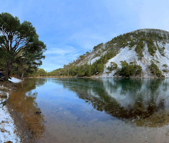
From the end of the road, head around a barrier, then folllow a good estate track heading initially east. After around 2km, you'll come to An Lochan Uaine  , the 'green lochan', it's worth stopping here to take in the atmosphere. No one quite knows why the loch is quite so green and there are legends surrounding this weird place.
A further 500m on from the lochan, the track comes to a junction  - left will take you to Ryvoan Bothy, Abernethy and the eastern foot of Meall a' Bhuachaille. Turn right for the track aiming towards Bynack More.

Bynack Mòr from Strath Nethy
 - this is where Bynack Stable was until 2007, when rumour has it, it was blown down in a storm. If you've cycled in, this is the spot to leave bikes. From the bridge, if you look up the Strath Nethy, you'll see Bynack Mòr ahead.
Bynack Mòr from Strath Nethy
3. Bynack More

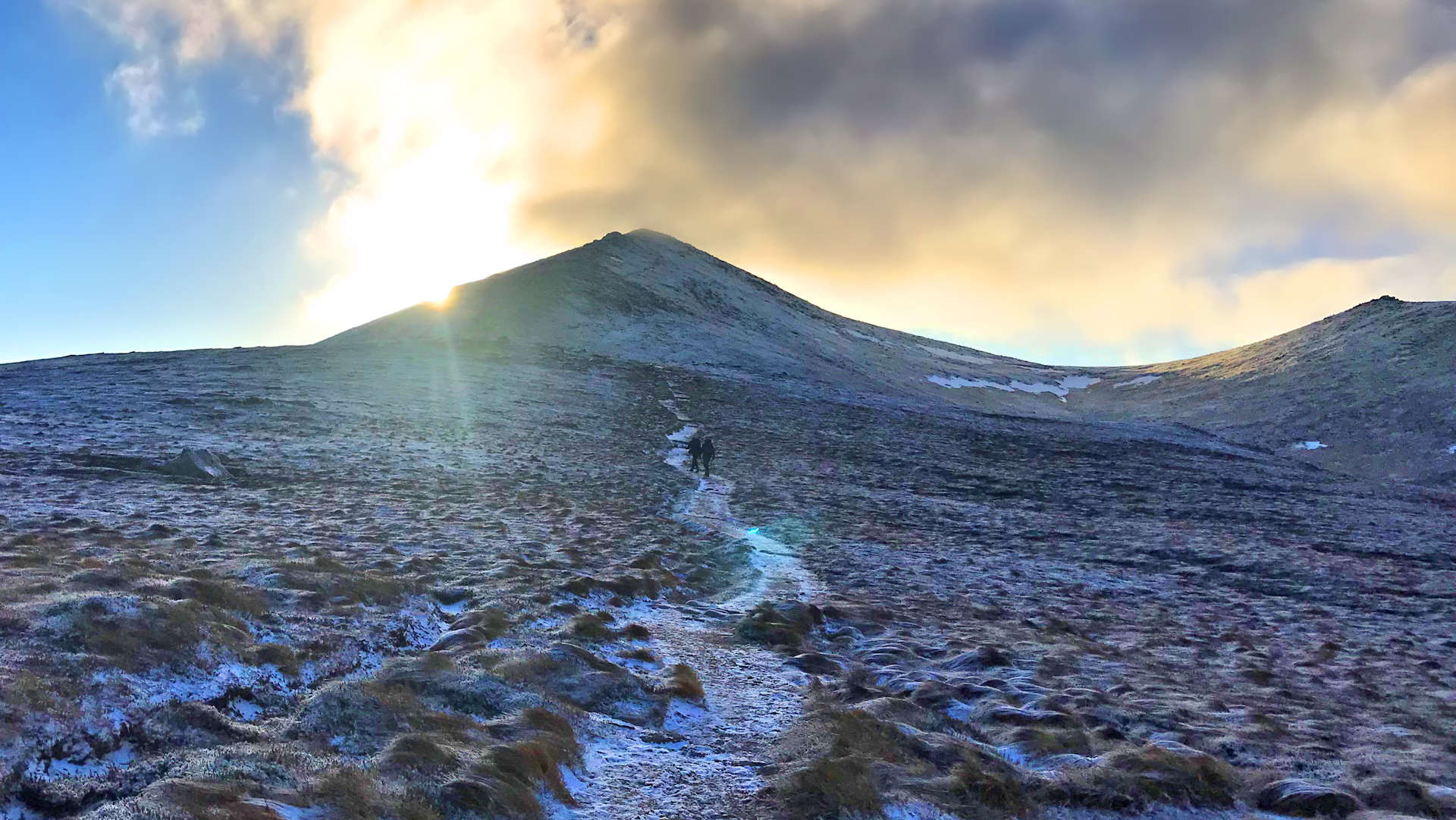
Hikers above the foot of Bynack More
Over the bridge and now on a well maintained path, aim south-east uphill. The path climbs gently, most fell-runners will be able to run up the gradient. I have cycled up this, but the frequency of drainage slabs took its toll on my tyres and I ended up with a puncture !
After climbing around 300m, the gradient levels out, then a further 1km on, at around c780m, a cairn  marks a junction in the path where the main path should be left by veering right.

Nearing Bynack More's summit, Meall a' Bhuachaille beyond
 , often a windy spot !
Nearing Bynack More's summit, Meall a' Bhuachaille beyond
4. Detour to Creag Mhor

Creag Mhòr from the path above Corrie of the Barns
From the cairn at c780m, keep left (east), staying on the main path as it heads south-east and begins to drop gradually into Coire Odhar. The path becomes quite rough and the ground in Coire Odhar becomes sodden around the burn crossing  . The path improves later as it contours around the eastern aspect of Bynack More, climbs up through heather and then drops again, this tìme into the Corrie of the Barns
  .
.
Now at the foot of Creag Mhor, aim directly (south-east) for the summit. It's a climb of only 250m, with the initial ascent through rough heather which easies as height is gained. Creag Mhòr's rocky summit comes into view and when reached, to touch the top  there's a bit of easy scrambling.
Retrace your route back to the Corrie of the Barns , then head north back up the path for around 500m. At a convenient point, leave the path and strike directly up the fall-line of Bynack More's eastern face. Some boulders and heather impede progress on the steep ground lower down, but higher up the gradient and terrain ease and a gentle walk reaches Bynack More's summit .
5. Barns of Bynack, Bynack Beg and return

The Barns of Bynack
From Bynack More's summit, you could just re-trace your steps and return north, but for more interest, head further south for a detour of 500m and a drop of around 50m to investigate The Barns of Bynack  - a weird group of granite tors.
To the north-west of Bynack More's summit is Bynack Beg  . This Munro Top has a fine view back down Strath Nethy and a faint path can be traced from the col between it and Bynack More back to the the foot of Bynack More for the return to Glenmore.
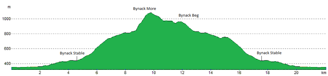
Route profile »
Maps and GPX downloads »


|
Download GPX of route |

|
Open route in OS Maps |
The map images above link to items on Amazon. A small commission is earned on any map purchased which helps fund the operating costs of this website.
Weather forecasts »
| Regional | MWIS - Cairngorms and Monadhliath |
| Peak specific | Mountain Forecast.com Met Office YR.no |
| Seasonal | SAIS - Northern Cairngorms Midge forecast |
Alternative and nearby routes »
Tour of Meall a' Bhuachaille | |

|
Hike over Meall a’ Bhuachaille from Badaguish following the hill race route on tracks and paths to traverse the hill's crest to Craiggowrie. Peaks : 1 Corbett
Ascent : 700m (2300ft) Distance : 13km (8m) Time : 4:30hr |
Geal Chàrn from Dorback | |

|
Hillwalking route up Geal Chàrn in Abernethy from Dorback Lodge where estate tracks lead to a fine circular hike over remote moorland. Peaks : 1 Corbett
Ascent : 600m (1970ft) Distance : 16km (10m) Time : 5:45hr |
Cairngorm and Ben Macdui | |

|
Hillwalking route up Ben Macdui and Cairn Gorm with an optional relatively easy scramble on Fiacaill Ridge in good summer conditions. Peaks : 2 Munros
Ascent : 1000m (3280ft) Distance : 17km (11m) Time : 6hr |
Ben Avon and Beinn a' Bhùird from Tomintoul | |

|
A delightful cycle through Glen Avon is followed by hiking paths on gentle slopes to pass weird rocky tors to reach the summits of Ben Avon and Beinn a' Bhùird. Peaks : 2 Munros, option of 1 Fiona
Ascent : 1600m (5250ft) Distance : 51km (32m) Time : 10:30hr |
West of Làirig Ghrù from Glenmore | |

|
Hillwalking route up Braeriach, Cairn Toul and Sgòr an Lochain Uaine, vast high plateaux west of the Làirig Ghru with superb views over the Cairngorms. Peaks : 3 Munros
Ascent : 1850m (6070ft) Distance : 28km (17m) Time : 10hr |


