

Marsco, Beinn Dearg Mhòr & Glamaig hillwalk
Hillwalking route over Marsco, Beinn Dearg Mhòr & Glamaig in Skye's Red Cuillin. Challenging ascents, scree slopes, and spectacular panoramic views.
Route outline
| Corbetts | ||||
| Fionas | ||||
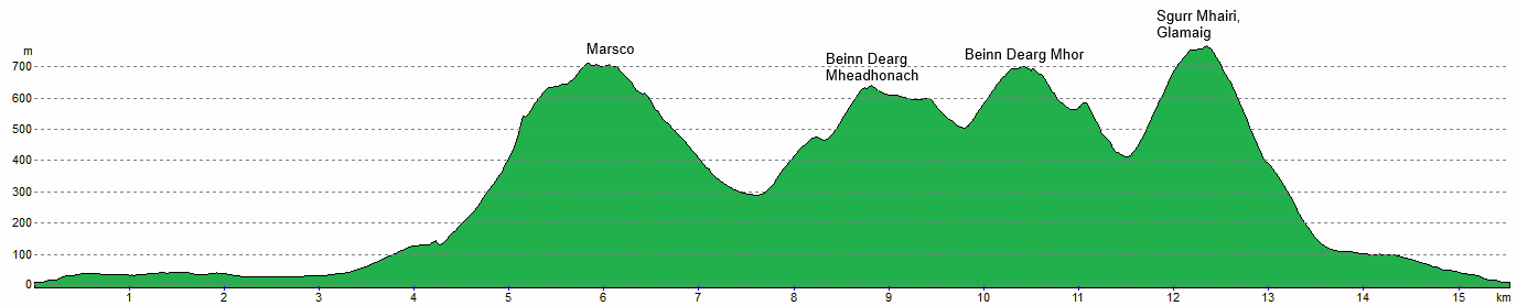
| Ascent | 1700m (5570ft) | |||
| Distance | 15km (9m) | |||
| Time | 6:30hr | |||
| Start/finish | Sligachan, Isle of Skye Grid Ref : NG485298 | |||
| Terrain |
| |||
| Nav |
| |||
| Effort |
| |||
| Scenery |
| |||


The granite-clad peaks of the Red Cuillin rise dramatically above the sea inlets of Loch Sligachan and Loch Ainort. Their summits offer spectacular panoramic views, especially across to the jagged ridges of Skye's Black Cuillin.
The terrain of the Red Cuillin presents a fair challenge to most hillwalkers. Scree, particularly abundant on Glamaig and Beinn Dearg Mhor, though less so on Marsco, makes for demanding ascents and tricky navigation. Paths can be scarce and often faint.
However, for those with strong ankles and a taste for adventure, the same scree slopes can make for exhilarating and swift descents - well-earned after a tough uphill slog.
Taking place in July is the legendary Glamaig Hill Race, a gruelling direct ascent and descent from the Sligachan Inn.
Show map
Route description
1. Getting to Sligachan

Glamaig above Sligachan Campsite
On the Isle of Skye, Sligachan with its hotel and campsite lies on the A87 by the junction where the A863 branches off west toward Carbost and overlooks the head of Loch Sligachan. There is a large parking area for the Sligachan Hotel which seems to be also available for hillwalkers. In addition there is a long layby with room for several cars to the rear of the hotel - do not block access to the Mountain Rescue building !
2. Marsco

Marsco from Glen Sligachan
Starting from the hotel the route begins by crossing the River Sligachan via the old bridge. Turning right by a right-of-way signpost, a path heads through a wall and climbs to a viewpoint with information boards.
Beyond the viewpoint, the path climbs for a short distance and reaches a fork. Taking the right fork, a rough path is followed for around 2.5km with Marsco in view ahead.
As the path nears the Allt na Measarroch  , a line of old fence posts mark a sharp branch in the path. Follow the path heading eastward aside the line of posts and above the northern bank of the burn for just over 1km. At a suitable crossing point , descend over heather to the Allt na Measarroch then begin to strike directly uphill.
The initial climb through thick heather gradually eases as elevation is gained with grassy slopes taking over. Higher up the ascent steepens but is never technical - just a sustained workout.

Stone circle on way to Marsco's summit
 is reached from where a pleasant walk leads to a stone circle, then a slight narrowing of the crest and change in direction onto its summit
  which offers superb views in all directions.
Stone circle on way to Marsco's summit
3. Beinn Dearg Mhor

Beinn Dearg Mheadhonach from above the Màm a' Phobuill
From Marsco's summit, follow the grass-covered crest of its south-eastern shoulder for around 500m losing around 100m of height and drop to a small grassy col  .
.
Turning north, faint traces of a zig-zagging worn path can be found to descend steep grassy slopes with occasional loose scree patches. Heading down into Coire nan Laogh and aiming for the pass of Màm a' Phobuill, a line of old iron posts is met, the gradient eases, a burn is crossed and grass is gradually replaced by heather.
Having reached Màm a' Phobuill  , ahead lies Cìche na Beinne Deirge, a prominent summit cloaked in boulders and scree. From the pass, rather than aiming north-east for this peak, aim for the bealach directly to the north of it - a sustained climb of 150m over loose boulders demanding effort and care !
Beyond the bealach, a faint path climbs steadily to the summit of Beinn Dearg Mheadhonach  , weaving through more bouldery ground.
Beyond Beinn Dearg Mheadhonach's summit, a faint path heads northwest, gradually turning northwards and meets with a small cairn  . There is a branch in the path here where a left-turn leads westwards down Druim na Ruaige - a useful alternative descent (see below).

Cloud lifting of Beinn Dearg Mhòr from Beinn Dearg Mheadhonach
 . The path becomes clearer here as it twists and turns winding its way uphill northeast and onto the summit of Beinn Dearg Mhòr
  , marked by a large cairn and surrounded by scree.
Cloud lifting of Beinn Dearg Mhòr from Beinn Dearg Mheadhonach
4. Sgùrr Mhairi, Glamaig

Looking back to Beinn Dearg Mhòr from Glamaig
Pressing northward from Beinn Dearg Mhor, the trail continues across more scree and boulders. As the crest begins to drop there is a split in the path - to the left is a direct descent down Teanga Mhòr and back to Sligachan. Stay with the path heading northwards as it curves slightly northeast around the rim of Coire nan Laogh and begins to lose some height.
The gradient eases just before a slight rise  - there is a change of direction in the route here which may not be obvious in mist. Look for the head of a path travelling northwest down a scree slope aiming for Bealach na Sgairde
  below.
Around 200m of height is lost to reach the bealach, from where Glamaig's intimidating scree slopes loom overhead. The climb up this is strenuous but not technical with traces of path to be found through the scree.
A final push leads to the cairn and trig point standing at the northwestern end of Sgùrr Mhàiri  , Glamaig's summit ridge. The views are breathtaking.

View from Glamaig over to Raasay
View from Glamaig over to Raasay
5. Descents

The scree descent of Glamaig
A direct descent can be made from Glamaig's summit heading west-southwest over steep, loose and rough terrain. Several paths can be found descending through scree and boulderfield. Once on gentler ground below, the Allt Daraich is crossed to return to Sligachan across heather and grass.
The direct descent from Glamaig can be brutal after a long day, so instead, a less punishing option could be taken by initially returning to Bealach na Sgairde . From this bealach descend southwest, following a developing path above the Allt Bealach na Sgairde down to cross the Allt Daraich and the return path to Sligachan.

Descent from Beinn Dearg Mheadhonach
to the north of Beinn Dearg Mheadhonach. This path cuts west through the scree, then curves northward across more level terrain. Cairns mark much of the way. The ground transitions to heather, where a path leads to the Allt Daraich and back to Sligachan.Descent from Beinn Dearg Mheadhonach
6. Glamaig Hill Race

Glamaig Hill Race start by Slighachan
The Glamaig Hill Race is infamous for its steep scree and boulder-strewn descent. It's not for the faint-hearted - but it's a thrilling event for both runners and spectators. A post-race ceilidh in the Sligachan's Seumas Bar make it a standout fixture on the hill-running calendar.
The race starts at the Sligachan Hotel. Runners cross the old bridge, jog briefly along the road, then pass through a gate. From here, route choice is free - though a faint wet trail through the heather and bogs leads to Glamaig's base.
The ascent begins on steep grassy slopes, gradually giving way to loose rock and scree. A grassy line, slightly left of the direct fall line, can ease the final stretch. At the summit, runners circle the cairn before descending.
For the return, some follow the ascent route, others hurl themselves down direct scree runs and boulderfields. The descent is punishing and demands skill, bravery, and sure footing. Once back on grass and bog, there's lively debate over the fastest finish - some head for the road, others make a beeline for the hotel. Either way, cheers erupt as runners cross the bridge to the finish.

Nearing the summit on the Glamaig Hill Race
Nearing the summit on the Glamaig Hill Race
Route profile »
Maps and GPX downloads »


|
Download GPX of route |

|
Open route in OS Maps |
The map images above link to items on Amazon. A small commission is earned on any map purchased which helps fund the operating costs of this website.
Weather forecasts »
| Regional | MWIS - Northwest Highlands |
| Peak specific | Mountain Forecast.com Met Office YR.no |
| Seasonal | Midge forecast |
Alternative and nearby routes »
Northern Cuillin Munros Scrambling Route | |

|
From Sligachan, a route tackling Sgùrr nan Gillean, Am Bàsteir & Bruach na Frithe with exposed Grade 3 scrambling and an optional Tooth Chimney abseil. Peaks : 3 Munros
Ascent : 1550m (5090ft) Distance : 15km (9m) Time : 6:45hr |
Garbh-bheinn & Belig Hillwalk Circuit, Isle of Skye | |

|
Rewarding Skye circuit over Garbh-bheinn & Belig. Rugged terrain, light scrambling, and superb views between Loch Ainort and Loch Slapin. Peaks : 1 Corbett, 1 Fiona
Ascent : 1125m (3690ft) Distance : 9km (6m) Time : 4:10hr |
Blà Bheinn (Blaven) hillwalk from Loch Slapin, Skye | |

|
Blà Bheinn (Blaven) is one of Skye’s finest Munros and from Loch Slapin gives a dramatic hike with light scrambling and stunning views to the Cuillin Ridge. Peaks : 1 Munro
Ascent : 930m (3050ft) Distance : 8km (5m) Time : 3:35hr |
Inaccessible Pinnacle & Sgùrr Mhic Chòinnich | |

|
A demanding Cuillin day with airy scrambles on Sgùrr Dearg, Sgùrr Mhic Chòinnich & Sgùrr na Banachdich—includes the In Pinn climb and abseil. Peaks : 2 Munros, option of additional Munro
Ascent : 1450m (4760ft) Distance : 10km (6m) Time : 7hr |
Sgùrr Alasdair via Great Stone Chute | |

|
A climb up Skye’s highest peak from Glenbrittle via Coire Làgan and the Great Stone Chute, ending in a short but exposed scramble. Peaks : 1 Munro
Ascent : 1025m (3360ft) Distance : 14km (9m) Time : 5:50hr |


