
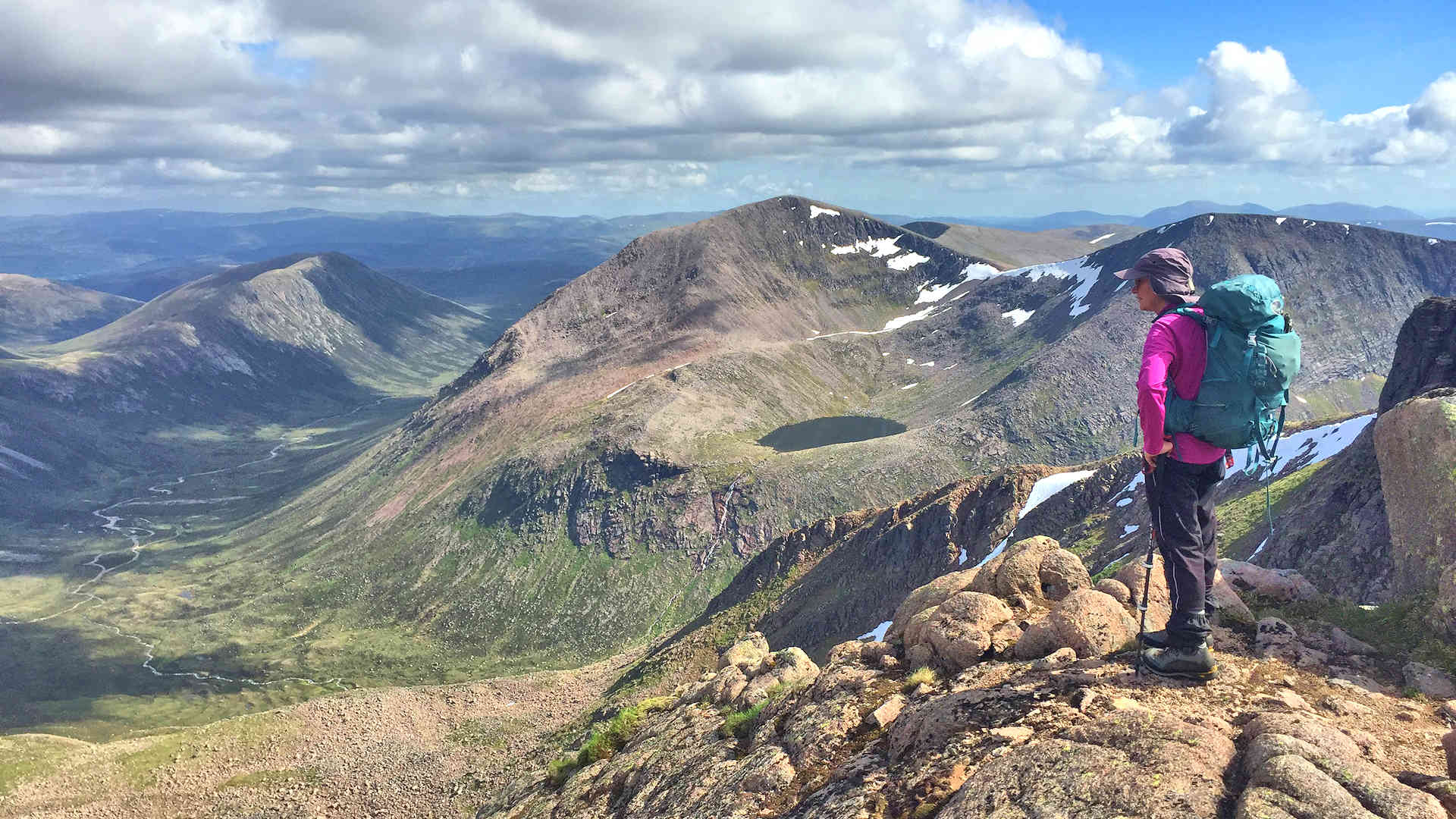
West of Làirig Ghrù from Glenmore
Hillwalking route up Braeriach, Cairn Toul and Sgòr an Lochain Uaine, vast high plateaux west of the Làirig Ghru with superb views over the Cairngorms.
Route outline
| Munros | ||||
| Ascent | 1850m (6060ft) | |||
| Distance | 28km (18m) | |||
| Time | 10:00hr | |||
| Start/finish | Sugar Bowl car-park, Glenmore Grid Ref : NH985073 | |||
| Terrain |
| |||
| Nav |
| |||
| Effort |
| |||
| Scenery |
| |||


The terrain changes dramatically from heather in the glens and lower hillsides, giving way to grass and boulder-fields higher up. Hiking on the arctic-like tundra on the plateaux you'll discover hidden lochans and waterfalls.
This route starts from the Sugar Bowl car-park and heads through the Càrn a'Chlamain Gap to the Làirig Ghrù on a fine path. Other alternative starting points begin from Loch Morlich and Coylumbridge, which are longer and through forestry, but offset by cycling part on estate tracks part of the way.
On the high plateaux, paths can for the most part be traced, though frequently paths disappear into boulderfield and good navigation skills will be needed. Some of the route follows the rims of coires above huge drops down to hiddens lochans, beware cornices can extend well beyond the edges in winter.
Show map

Route description
1. Getting to the Sugar Bowl car-park

Entrance to Sugarbowl car-park with rainbow over Meall a' Bhuachaille
On the south side of Aviemore, there is a roundabout, from where the road to Cairngorm Mountain begins. It's a journey of around 12km passing lovely Loch Morlich on the way. The car-park is located on a sharp uphill bend around 3km beyond Loch Morlich.
There is a parking charge, £2 at tìme of writing, or you can buy a season-pass from Glenmore Visitor Centre.
There are alternative starting points at Coylumbridge and the western end of Loch Morlich. Both of these are slightly longer, though you can bike it in for a fair distance.
2. Through the Chalamain Gap to Làirig Ghru

In the Chalamain Gap
From the Sugar Bowl car-park, cross the road and on a well-constructed path, head down towards the Allt Mòr burn. Over the bridge  and climb up the other side out of woodland. Reindeer are kept in the fenced area by here.
Follow the path into the Chalamain Gap  , a weird rocky gash. The path through the gap is fine, but can be hard work in winter if banked up in snow, in which case, there is another path traversing above the crags on the north side of the gap. Out the other side, staying on the path, drop down into the Làirig Ghrù
  .
.

Cairn Toul from the Pools of Dee in the Làirig Ghru
 , marked with a cairn. The path does get a bit faint in bits and easily lost.
Cairn Toul from the Pools of Dee in the Làirig Ghru
3. Cairn Toul

Garbh Choire refuge below Sgòr an Lochain Uaine
From the highest point in the Làirig Ghru, aim south to the Pools of Dee  , then pick up a very faint path on the western side of the Làirig Ghrù. The path comes and goes as it cuts a way through heather, dropping gently and turning south-west into Garbh Coire. Approaching the Allt a'Gharbh-choire, the path disappears, but you should be able to see the refuge ahead
  (grid ref NN959986) - make a beeline for this, crossing the burn on the way (difficult or impossible in spate). Note the refuge is marked on Harvey Maps and OS Landranger, but not on OS Explorer.
Aiming immediately south of the refuge, try and pick a route through heather and begin climbing. The steep ground above and ahead is slabby, but there is a break between the crags  and a faint and loose path zig-zags a route through this and up onto the ground near the outlflow of Lochan Uaine
  .
.

Heading up the northern shoulder of Cairn Toul
- Cairn Toul's northern spur
The easiest line is to cross the outflow of the lochan and head up Cairn Toul's north ridge. This is a wide shoulder with some boulderfield, but is relatively straightforward aiming directly for Cairn Toul's summit and gives a lovely views back over the lochan to Braeriach. - Sgòr an Lochain Uaine's north-east ridge
Instead of crossing the outflow of Lochan Uaine, turn south-west and begin clambering over boulders up Sgòr an Lochain Uaine's north-east shoulder. The terrain begins to get scrambly (Grade 1), but never too difficult until higher up, where an angled slab is met - turn to the left to go around.Next the crux of the ridge is reached - intimidating rock blocks the way. Go to the right a few steps and look directly up, a commiting clamber onto a ledge is required, thereafter some easy scrambling leads to the summit of the Angel's Peak, Sgòr an Lochan Uaine .Obviously you'll need to do a there-and-back to Cairn Toul from Sgòr an Lochain Uaine's summit
There are two cairns on Cairn Toul's summit crest
 , the northern one marks the top.
Heading up the northern shoulder of Cairn Toul
4. Sgòr an Lochain Uaine

On route to Sgòr an Lochain Uaine, looking back to Cairn Toul
From Cairn Toul's northern cairn, aim west and handrail the rim above Coire an Lochain Uaine. A path can be followed most of the way, occasionally zig-zagging to avoid some boulders, down to the bealach between Cairn Toul and Sgòr an Lochain Uaine.

Looking to Ben Macdui from Sgòr an Lochan Uaine
(also known as The Angel's Peak), a fine viewpoint to Braeriach and Ben Macdui.Looking to Ben Macdui from Sgòr an Lochan Uaine
5. Braeriach

Càrn na Criche from the south-east
Leaving Sgòr an Lochain Uaine behind, hike south-west following the edge of the crags above Garbh Coire. Terrain underfoot is annoyingly bouldery in bits, but as height is lost, becomes more relaxed. From the next bealach, start uphill on a fine path cutting a route through the loose arctic-like tundra. Càrn na Criche  is the high point of the next plateau, there's a small cairn on the summit, which can be bypassed if taking a direct route onwards.
Now on grass-covered ground, aim north-north-east for the Wells of Dee  , an extraordinary place where two burns meet, then flow over the Falls of Dee.

Summit of Braeriach
 appears abruptly, the cairn perched above massive drops of Coire Bhrochain, in winter, beware the cornices that can form ! . Views are stunning, particulary back over to Cairn Toul.
Summit of Braeriach
6. Return through the Chalamain Gap

Descending Braeriach back towards the Làirig Ghru
Follow the rim of Coire Bhrochain north-east, then east. A path quickly forms as terrain gets easier, then leads down to the bealach below Sròn na Lairige (if you're here and need to get out of wild weather, there is an escape route directly down to the Làirig Ghrù below).
The path leads around Sròn na Lairige's summit  over a delightful grass-covered crest as it approaches the top of the crags above the Làirig Ghrù. Just when legs are starting to tire, more stony ground and boulderfield needs crossed as the descent to the Làirig Ghrù begins. The path becomes more maintained as it enters heather and does its final drop into the Làirig Ghrù .

On the way to the Làirig Ghru, Creag a' Chalamain ahead
On the way to the Làirig Ghru, Creag a' Chalamain ahead
Route profile »

Maps and GPX downloads »


The map images above link to items on Amazon. A small commission is earned on any map purchased which helps fund the operating costs of this website.
Weather forecasts »
| Regional | MWIS - Cairngorms and Monadhliath |
| Peak specific | Mountain Forecast.com Met Office YR.no |
| Seasonal | SAIS - Northern Cairngorms Midge forecast |
Alternative and nearby routes »
Cairngorm 4000s | |

|
Circular hillwalking route over the Cairngorm 4000ers from Glenmore, including Ben Macdui, Braeriach, Cairn Toul, Sgòr an Lochain Uaine and Cairn Gorm. Peaks : 5 Munros
Ascent : 2250m (7380ft) Distance : 28km (17m) Time : 10:45hr |
Sgòr Gaoith and Braeriach from Loch Einich | |

|
Through Glen Einich to Braeriach and Sgòr Gaoith, with the option to backpack and camp by the lochans on the wild Moine Mhòr plain. Peaks : 2 Munros
Ascent : 1680m (5510ft) Distance : 42km (26m) Time : 9hr |
Sgòr Gaoith and Mullach Clach a' Bhlair from Glen Feshie | |

|
Hillwalking route up Sgòr Gaoith and Mullach Clach a’ Bhlàir from Rothiemurchus, with paths across the Moine Mhòr above Glen Feshie’s forests and rivers. Peaks : 2 Munros
Ascent : 1100m (3610ft) Distance : 26km (16m) Time : 8:20hr |
Meall a' Bhuachaille from Glenmore | |

|
Hillwalk from Glenmore via Ryvoan and the Green Lochan to Meall a' Bhuachaille, passing Ryvoan Bothy before a direct ascent on a decent path. Peaks : 1 Corbett
Ascent : 550m (1800ft) Distance : 9km (6m) Time : 3:15hr |
Bynack More and Creag Mhòr from Glenmore | |

|
Hillwalking route from Glenmore up Bynack Mòr and Creag Mhòr. A bike helps access these hills, where weird granite tors crown the summits. Peaks : 1 Munro, 1 Corbett
Ascent : 860m (2820ft) Distance : 22km (14m) Time : 5:30hr |


