

Beinn Ghobhlach from Badrallach
Beinn Ghobhlach from Badrallach follows a coastal track before crossing pathless ground past small lochs to reach the summit, with outstanding views throughout.
Route outline
| Fionas | ||||
| Ascent | 720m (2360ft) | |||
| Distance | 11km (7m) | |||
| Time | 4:00hr | |||
| Start/finish | Badrallach, Dundonnell Grid Ref : NH058919 | |||
| Terrain |
| |||
| Nav |
| |||
| Effort |
| |||
| Scenery |
| |||


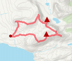
Approaching Beinn Ghobhlach from Badrallach begins on a well-made track that travels along the coast before pathless terrain is encountered to gain the lochans below the hill's southern slopes.
Above the lochans, two main options present themselves: a more direct ascent from the south-west involving steeper grassy slopes and short sections of sandstone rock, or a longer but gentler approach around the eastern side of the hill.
Show map

Route description
1. Getting to Badallrach

End of public road by Badrallach
The route begins from the shores of Little Loch Broom, reached from the A832 which branches off the A835 at the Braemore junction near the Corrieshalloch Gorge. The road passes through open moorland before descending towards Dundonnell at the head of Little Loch Broom.
Approximately 3km south of Dundonnell, a signed turning for Badrallach leads north along a narrow single-track road. This climbs steadily by almost 250m before descending to the small settlement of Badrallach, where a handful of houses and a campsite are located.
Parking is available at the end of the public road, taking care not to block the turning circle.
2. Beinn Ghobhlach

Beinn Ghobhlach from the eastern shore of Loch na Coireig
From the end of the public road, a sign indicates the Ceum Path to Sgoraig. Beside this, a narrow but well-constructed track rises briefly before levelling out and continuing at a steady height above the shoreline of Little Loch Broom, with fine views across the loch to Sàil Mhòr.
After approximately 1.5km, the track curves slightly  . At this point, it is left behind and higher ground is gained directly to the north. The slope is relatively steep but largely grass-covered, and after a climb of around 200m a broad pass is reached. Here, a wide sandstone slab
  provides a natural viewpoint, with Beinn Ghobhlach seen ahead and reflected in Loch na h-Uidhe.
Beyond this point, the ground becomes rougher and more heather-covered. Two main options present themselves to reach the base of Beinn Ghobhlach: a fairly direct line between between Loch na h-Uidhe and Loch na Coireig, or a longer line taken around the eastern side of Loch na Coireig. Although more circuitous, the eastern option offers easier going on particularly attractive beach along the loch shore.
From the lochs  , two lines of ascent present themselves. One takes a generally grassy line close to a band of sandstone crags and rises steeply towards the summit, finishing with a short section of easy sandstone clambering which, in most conditions, presents little difficulty. A second, more gradual option continues north-east towards Loch a’ Bhealaich
  before approaching the summit from the south-east and ascending the hill’s eastern side. This line is longer but avoids steeper ground and remains on grass and stunted heather for most of the ascent.
The summit of Beinn Ghobhlach  is marked by a substantial stone-walled shelter, forming a circular structure that provides effective protection in exposed conditions.

An Teallach and Sàil Mhòr from Beinn Ghobhlach's summit
An Teallach and Sàil Mhòr from Beinn Ghobhlach's summit
3. Return to Badallrach

Returning to Loch na Coireig and Loch na h-Uidhe
The return is normally made by the outward route. Variations are possible, including a descent through Coire Dearg to the north of Beinn Ghobhlach, or an ascent of Cnoc a’ Bhaid-rallaich, before the track above Little Loch Broom is regained for the walk back to Badrallach.
Route profile »

Maps and GPX downloads »


|
Download GPX of route |

|
Open route in OS Maps |
The map images above link to items on Amazon. A small commission is earned on any map purchased which helps fund the operating costs of this website.
Weather forecasts »
| Regional | MWIS - Northwest Highlands |
| Peak specific | Mountain Forecast.com Met Office YR.no |
| Seasonal | SAIS - Torridon Midge forecast |
Alternative and nearby routes »
Sàil Mhòr from Ardessie | |

|
Hillwalking route up Sàil Mhòr from Ardessie above Little Loch Broom. A direct line with a detour around crags makes for a fine afternoon’s hike. Peaks : 1 Corbett
Ascent : 850m (2790ft) Distance : 9km (6m) Time : 3:40hr |
An Teallach | |

|
Hillwalking route on An Teallach, with moderate scrambling along its famous ridge to reach Munro summits Bidein a' Ghlas Thuill and Sgùrr Fiona. Peaks : 2 Munros
Ascent : 1270m (4170ft) Distance : 13km (8m) Time : 5:20hr |
Beinn Enaiglair from Braemore | |

|
From Braemore Junction, a fine hillwalk over tracks and heather slopes to Beinn Enaiglair, with an optional extension to nearby Meall Doire Fàid. Peaks : 1 Corbett, plus option of 1 Fiona
Ascent : 740m (2430ft) Distance : 12km (7m) Time : 4:15hr |
Ben More Coigach and Sgùrr an Fhidhleir | |
|
From Achiltibuie, a circular route explores Ben More Coigach, Sgùrr an Fhidhleir and nearby tops, with superb views over Coigach and the Summer Isles. Peaks : 2 Fionas
Ascent : 1035m (3400ft) Distance : 15km (9m) Time : 5:30hr |
Inverlael Munros | |

|
Hillwalking route up Beinn Dearg and neighbouring Munros from Inverlael. Tracks and old paths lead into vast forests to this bouldery Munro dome. Peaks : 6 Munros, option of 1 Graham
Ascent : 2600m (8530ft) Distance : 35km (22m) Time : 13hr |


