

Beinn Leoid, Meallan a' Chuail and Meall an Fheur Loch
Hillwalking route up Beinn Leòid from Loch Merkland. Using fine stalker’s paths, this outing also bags Meallan a’ Chuail and Meall an Fheur Loch.
Route outline
| Corbetts | ||||
| Fionas | ||||
| Ascent | 1175m (3850ft) | |||
| Distance | 17km (11m) | |||
| Time | 6:10hr | |||
| Start/finish | Kinloch Brae, Loch Merkland Grid Ref : NC357334 | |||
| Terrain |
| |||
| Nav |
| |||
| Effort |
| |||
| Scenery |
| |||


Some stunning views to be taken in while hiking up this rugged route over the Corbett Beinn Leòid and neighbouring Fionas Meallan a' Chuail and Meall an Fheur Loch.
Stalker's path access into the wild area from the north-east by Loch Merkland, thereafter terrain can be rough and pathless presenting navigation challenges.
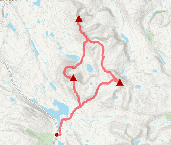
Show map

Route description
1. Getting to Loch Merkland

Stalkers path near West Merkland
North of Lairg the A838 follows the eastern shore of Loch Shin through a vast land of moor and forestry. At the northern end of Loch Shin the road wynds further and around Loch Merkland before aiming for more dramatic countryside.
The starting point for this route is on the A838, just over 1km west of the northern tip of Loch Merkland, where a small wooden bridge can be seen crossing the Allt Cean Locha.
There is a small parking area with sufficient space for 3 or 4 cars just to the east of the bridge.
2. Beinn Leòid via Loch Dubh

Beinn Leoid above Loch Dubh
From the roadside, what appears a faint stalkers path makes a route through felled forestry southwards up a hillside ahead.
Once over the footbridge the path quickly becomes less overgrown and transforms into a well constructed path as it twists and turns climbing steeply uphill.
A fair height above the forestry, the gradient begins to ease and at the 450m contour, ground levels out with Meallan a' Chuail and Beinn Leòid appearing distant ahead. Some soggy undulating ground is crossed and the path ends abruptly by a small cairn  .
.
From the cairn, turn southwards and hike over undulating grass covered terrain to reach the foot of Meallan a'Chuail's northern crest  .
.
Start to head south-west, contouring around Meallan a'Chuail north-west aspect and lose a little height.
The terrain is fairly rough, but after around 1km of crossing heather, grass and peat another stalkers path  is joined.
This stalker's path leads up to the wide, flat bealach
is joined.
This stalker's path leads up to the wide, flat bealach  between Meallan a'Chuail and Beinn Leòid.
Once onto the col, the ground underfoot becomes more gentle and a faint occasional path can be detected aiming up Beinn Leòid's eastern shoulder.
The ground rises and a small cairn  is found denoting there's only 1km further to reach Beinn Leòid's summit.
Higher up boulderfields begin to appear, though they never hinder progress much and the summit
is found denoting there's only 1km further to reach Beinn Leòid's summit.
Higher up boulderfields begin to appear, though they never hinder progress much and the summit  with its trig point sheltering behind a small dyke is finally gained.
Views are quite outstanding !
3. Meallan a' Chuaill

Meallan a' Chuail from the cairn on Beinn Leoid
From Beinn Leòid's summit, about turn and retrace your steps pass the cairn to the bealach .
Meallan a' Chuail is directly ahead, it's summit a direct and mere 200m climb up its western shoulder.
Begin to hike up grassy slopes and around halfway up the hillside  , try to aim slightly south of a direct line to the summit - this will keep on a route avoiding sections of boulderfields and rocks that would otherwise require negotiating.
A tiny cairn obscured by grass rests on Meallan a' Chuail's summit  , from where views are superb, with a particularly fine aspect of Ben More Assynt and Convial being given.
4. Meall an Fheur Loch

Meall an Fheur Loch from Meallan a' Chuail with Ben Hope and Ben Loyal beyond
From Meallan a'Chuail's summit turn northwards and pick up a faint path.
Alas, the path doesn't last and ends in some bouldery ground. Picking a route over the rocks, aim north-east and drop to a delightful grass covered crest.
On my first visit to bag these hills, weather was pretty dreich and I baled out at around the 500m contour  by continuing northwards to re-join the stalker's track by the cairn .
If weather is fine (which it was for me on subsequent visits), from the 500m contour, turn east and drop down over heather and grass, picking up the occasional deer-trod, to meet with the outflowing burn  from Loch Cul a' Mhill.
The climb up Meall an Fheur Loch is a straightforward hike up a gentle grassy slope and onto a wide flat plateau, where a cairn marks the highest point  .
.
Fine views from here, especially to Ben Hope and Ben Loyal.
5. Return

Summit cairn on Meall an Fheur Loch looking back to Meallan a' Chuail and Beinn Leoid
By Meall an Fheur Loch's summit cairn, turn and aim north-east, then hike over the wide crest for around 500m or so. Further on ground gets rougher as a route is made downhill through thickening heather.
The stalker's path  hiked up earlier in the day is met, from where a simple retrace of your route is made back to the forestry by Loch Merkland.
Route profile »

Maps and GPX downloads »

|
Download GPX of route |

|
Open route in OS Maps |
The map images above link to items on Amazon. A small commission is earned on any map purchased which helps fund the operating costs of this website.
Weather forecasts »
| Regional | MWIS - Northwest Highlands |
| Peak specific | Mountain Forecast.com Met Office YR.no |
| Seasonal | Midge forecast |
Alternative and nearby routes »
Ben Hee from Loch Merkland | |

|
Hillwalking route up Ben Hee from West Merkland. A direct but rough line over pathless, bouldery terrain gains this domed hill above Loch Merkland. Peaks : 1 Corbett
Ascent : 850m (2790ft) Distance : 14km (9m) Time : 4:55hr |
Meallan Liath Coire Mhic Dhughaill and Meall Horn | |

|
Hillwalking route from Loch More over Meallan Liath Coire Mhic Dhughaill and Meall Horn, two fine Corbetts in the remote Reay Forest. Peaks : 2 Corbetts, 1 Fiona
Ascent : 1600m (5250ft) Distance : 22km (14m) Time : 8:10hr |
Assynt Munros from Glen Cassley | |

|
Hillwalking route up Ben More Assynt and Conival from Glen Cassley. A quieter alternative to Inchnadamph, showing another side to these Assynt Munros. Peaks : 2 Munros
Ascent : 1035m (3400ft) Distance : 26km (16m) Time : 4:20hr |
Foinaven and Arkle from Loch Stack | |

|
Hillwalking route up Foinaven and Arkle from Stack Lodge. Estate tracks give way to steep, rough ground leading to the narrow crests of these superb peaks. Peaks : 2 Corbetts
Ascent : 2175m (7140ft) Distance : 31km (19m) Time : 11:30hr |
Reay Forest Corbetts from Lone | |
|
Hillwalking route up Foinaven, Meall Hòrn and Arkle from Achfary. A demanding circular over three Reay Forest Corbetts on rough crests and complex terrain. Peaks : 3 Corbetts
Ascent : 2550m (8370ft) Distance : 31km (19m) Time : 12hr |


