

Ben Hee from Loch Merkland
Hillwalking route up Ben Hee from West Merkland. A direct but rough line over pathless, bouldery terrain gains this domed hill above Loch Merkland.
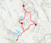
Route outline
| Corbetts | ||||
| Ascent | 850m (2780ft) | |||
| Distance | 14km (9m) | |||
| Time | 4:55hr | |||
| Start/finish | West Merkland Grid Ref : NC384329 | |||
| Terrain |
| |||
| Nav |
| |||
| Effort |
| |||
| Scenery |
| |||


The route most hillwalkers take begins from West Merkland following an estate track, then an old stalkers path to within striking distance of Ben Hee's summit. Instead of a return descent, heading down Ben Hee's northern spurs reveals its more interesting and hidden aspects with rocky slabs and buttresses rising above Loch an t-Seilg.
Alternatively, a short and direct there-and-back route from the mast above Loch Merkland requires hiking a distance of just 8km.
Show map

Route description
1. Getting to West Merkland

Estate track above West Merkland
North of Lairg the A838 follows the eastern shore of Loch Shin through a vast land of moor and forestry. At the northern end of Loch Shin the road wynds further and around Loch Merkland before aiming for more dramatic countryside.
The starting point for this route is on the A838 near the northern end of Loch Merkland, where by the house and outbuildings at West Merkland a gate marks the start of the route up an estate.
Parking nearby is limited to verges adjacent to passing places. There is a decent sized parking area around 1km west of West Merkland by the end of the loch.
2. Ben Hee

The Allt Coir' a' Chruiteir and Ben Hee
By the house at West Merkland, a gate on the east side of the Allt nan Albannach denotes the start of an estate track heading into the wilderness beyond Ben Hee and eventually to Strath More. Head through the gate and begin up the track.
After hiking for just under 2km, look for a small cairn  just before the track crosses the Allt Coir' a' Chruiteir. This cairn marks the beginning of an otherwise obscure old stalkers path heading eastwards, uphill and following course of the Allt Coire a' Chruiteir. The path is rough, vague and frequently very soggy but can be traced to around the 600m contour, passing some delightful waterfalls on the way.
With Ben Hee's summit dome now above and in front, the path disappears into marshy ground - some direction help from a few small cairns ahead.
Past the cairns, simply aim for Ben Hee's summit, passing some solifluction lobes then hiking over some boulderfield when nearing the top.

Cairns aiding navigation near Ben Hee's top
 , though there is a small cairn just to the north of this. Excellent views from the crest over the vast landscape, with the outlook onto Ben Hope being particularly fine.
Cairns aiding navigation near Ben Hee's top
3. Return

Ben Hope from Ben Hee's summit trig
The easiest option for return is to about turn and re-trace your route.
A longer and more challenging alternative is to head northwards and down to the lochans of Bealach nam Meirleach, which also gives the option of hiking up the two Fiona hills of Beinn Direach and Càrn an Tionail.
To take this longer option, from Ben Hee's summit, begin to head north-west following summit crest, at same tìme attempting to keep east of boulderfield and on easier grassy terrain.
When beginning to lose height, start to turn towards a more northerly direction. There is no path to follow and terrain becomes pretty rough while bounding down grass, rocks and some steep hillside.
Lower down aim through heather and marsh for the natural land-causeway  between Loch an Aslaird and Loch an t-Seilg. To cross onto the causeway there is a burn between these lochs needing negotiated, which will be difficult (or even impossible) to cross in spate.

Descending to Loch an t-Seilg, Meall a' Chleirich ahead
 , and follow it south-west to the highest point
  on Bealach nam Meirleach. A gentle downhill is all that's left for a return to the roadside at West Merkland.
Descending to Loch an t-Seilg, Meall a' Chleirich ahead
4. Ben Hee alternative, direct from mast

Approaching Ben Hee from Meallan Liath Mor
The first tìme I headed up Ben Hee, I took a direct route from Loch Merkland. This is outlined here and is the dashed line on map (total ascent 800m over a distance of 8km).
Above Loch Merkland, about half way along the loch, there is a mast around 50m above the road. Park below this mast on the roadside.
Begin uphill on a rough track to reach the mast  .
Beyond the mast there are no paths, just grass and a fairly steep incline.
Above the mast, after ascending a further 100m or so, the slope gradient easies.
.
Beyond the mast there are no paths, just grass and a fairly steep incline.
Above the mast, after ascending a further 100m or so, the slope gradient easies.
Aim generally northwards as the incline steepens again while the slopes of Meallan Liath Mòr are climbed.
As the ground levels, Meallan Liath Mòr's summit  is reached and Ben Hee's summit dome comes into view.
After passing a cairn, there are some ATV tracks and a small shelter to be found while aiming for the bealach  between Meallan Liath Mòr and Ben Hee.
From the bealach, all that remains to reach Ben Hee's summit is to find a grassy route through the boulderfields on the climb ahead, though higher up, the boulderfield is unavoidable.
Route profile »

Maps and GPX downloads »


|
Download GPX of route |

|
Open route in OS Maps |
The map images above link to items on Amazon. A small commission is earned on any map purchased which helps fund the operating costs of this website.
Weather forecasts »
| Regional | MWIS - Northwest Highlands |
| Peak specific | Mountain Forecast.com Met Office YR.no |
| Seasonal | Midge forecast |
Alternative and nearby routes »
Meallan Liath Coire Mhic Dhughaill and Meall Horn | |

|
Hillwalking route from Loch More over Meallan Liath Coire Mhic Dhughaill and Meall Horn, two fine Corbetts in the remote Reay Forest. Peaks : 2 Corbetts, 1 Fiona
Ascent : 1600m (5250ft) Distance : 22km (14m) Time : 8:10hr |
Beinn Leoid, Meallan a' Chuail and Meall an Fheur Loch | |

|
Hillwalking route up Beinn Leòid from Loch Merkland. Using fine stalker’s paths, this outing also bags Meallan a’ Chuail and Meall an Fheur Loch. Peaks : 1 Corbett, 2 Fionas
Ascent : 1175m (3850ft) Distance : 17km (11m) Time : 6:10hr |
Ben Klibreck from Strath Vagastie | |

|
Ben Klibreck is a vast rolling mountain in the far north. This hillwalking route from Strath Vagastie takes most direct ascent to its summit Meall nan Con. Peaks : 1 Munro
Ascent : 825m (2710ft) Distance : 14km (9m) Time : 5hr |
Reay Forest Corbetts from Lone | |
|
Hillwalking route up Foinaven, Meall Hòrn and Arkle from Achfary. A demanding circular over three Reay Forest Corbetts on rough crests and complex terrain. Peaks : 3 Corbetts
Ascent : 2550m (8370ft) Distance : 31km (19m) Time : 12hr |


