
Glen Ey and Altanour Munros
Circular hillwalking route above Glen Ey and Altanour Lodge ruins to Glas Tulaichean and 4 other Munros accessed by a 8km cycle from Inverey.
Route outline
| Munros | ||||
| Walk ascent | 1900m (6230ft) | |||
| distance | 24km (15m) | |||
| time | 8:30hr | |||
| Bike ascent | 150m (490ft) | |||
| distance | 16km (10m) | |||
| time | 2:00hr | |||
| Start/finish | Inverey, Braemar Grid Ref : NO089892 | |||
| Terrain |
| |||
| Nav |
| |||
| Effort |
| |||
| Scenery |
| |||


The terrain on the Munros around Glen Ey is easy underfoot, being mainly heather and grass covered, with occasional rocky ground confined to patches on some of the summits.
Beyond the main track in Glen Ey there is little in the way of good paths, therefore your navigation skills will be tested on misty days, particularly on the featureless landscape between Càrn Bhac and Beinn Iutharn Mhòr and the heather covered terrain between Glas Tulaichean and An Socach.
Show map

Route description
1. Getting to the start by Inverey

Cycling down Glen Ey
From Braemar, drive west along its main street, veering right at the Coffee Stop, then continue along an unclassified road for around 7km to the hamlet of Invervey. On the opposite side of the road from a row of houses and by a memorial, there is a designated area to park several cars.
2. Approach in to Altanour Lodge ruin

Altanour below Beinn Iutharn Mhor
On bike, cycle down Glen Ey on this track that heads south from the car-park at Inverey. You'll pass through some land with a large house and some old forest, then continue for just under 1km to a bridge  over Ey Burn. Ahead the track steepens suddenly - this short section is the only tough bit of cycling on the route - beyond this, the track continues fairly flat with only a few gently rises to contend with. Deer often gather in this glen - cycling with them as they gallop is quite exhilarating.
The track crosses two more bridges over Ey Burn at two more locations  and
and  , the last around 1km before the ruins of Altanour Lodge
  .
.
Drop your bike off by the ruins.
3. Càrn Bhac

Càrn Bhac from the Allt nan Clach Geala
From Altanhour Lodge ruins, follow an ATV track on grass heading south-west from the lodge. After around 200m, the track path splits, keep right, staying on the north side of the Alltan Odhar.
A further 1km, the track crosses the Alltan Odhar  and begins to climb up the southern shoulder of Càrn Bhac. Grouse-butts appear further on.
The track becomes fainter at around 700m and a faint path is then traced north-west. Further on and at around 800m, an obvious worn scar of the path can be seen ahead, white stones sticking out of peat. Follow this to the summit, crossing a band of stones which indicate the summit is not much further.
Stoney ground on the summit surrounds Càrn Bhac's large cairn  and views are quite exceptional towards the Cairngorms considering Càrn Bhac's flat shape and diminutive height compared to other mountains all around.
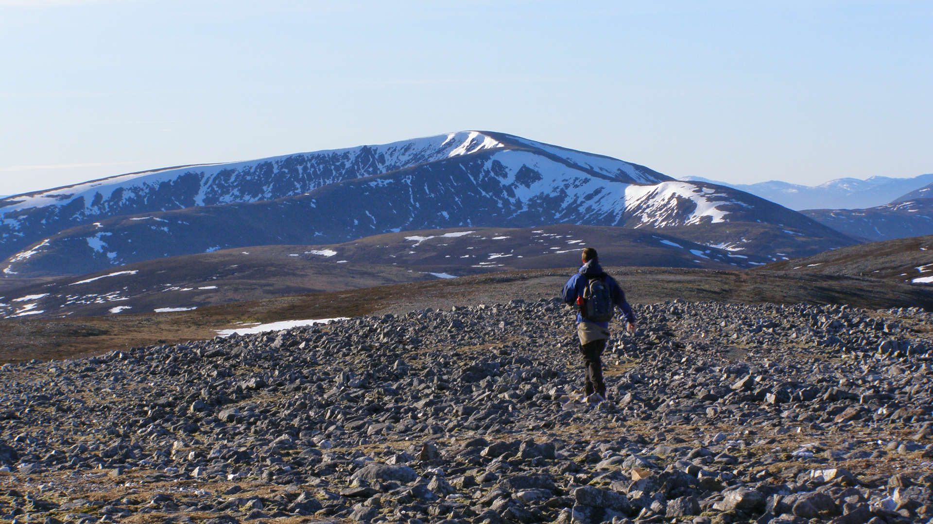
4. Beinn Iutharn Mhor

Walking along Beinn Iutharn Mhòr's crest
From Càrn Bhac's summit, head south-west for the col before the minor top  (marked 920m on maps). Continue heading south-west, below and around this top, then turn south gradually losing height on grass-covered ground.
As the ground levels out, it becomes peat-hagged, though you should be able to trace a faint path to the next rise (marked 818m) then down to a col  below Beinn Iutharn Mhòr. Ascend a grass-covered slope, again there's a faint path to trace, and reach the bottom of Beinn Iutharn's bouldery north-east shoulder. Alas, there's no choice but to head directly up the steep loose terrain ahead - there are some faint sections of path cutting through scree that can be found.
Once on the shoulder's crest  , it's back onto easier grass-covered terrain and an obvious path is followed around Beinn Iutharn Mhòr's northern coire to the tidy cairn on the summit
  .
.
5. Càrn an Righ

Càrn an Rìgh's summit cairn with Beinn a'Ghlo behind
Leave Beinn Iutharn Mhòr's cairn and head south, then south-east-south for just under 1km over grass to a col  .
.
Climb around 20m, the ground flattens and a faint path appears heading off right - follow this path south-west around the minor summit of Màm nan Càrn. The path becomes more obvious as it cuts a way though stoney ground and nears the heathery and peat-hagged col between Màm nan Càrn and Càrn an Rìgh.
At the col  below Càrn an Righ, a very obvious and badly boot-worn route climbs directly ahead through more peat and heather.
Higher up some bouldery areas are crossed with the path snaking through. The summit cairn  of Càrn an Rìgh is reached where a fine vista over Beinn a'Ghlo can be savoured.
6. Glas Tulaichean

Glas Tulaichean from Càrn an Righ
From Càrn an Rìgh's summit, return to the bealach between Càrn an Rìgh and Màm nan Carn, then leave the path and bound over heather to follow a burn south-east down to the grassy foot of Glas Tulaichean  .
.
Cross the burn in the glen , then aim south-east directly uphill on grassy, occasionally wet and ever steepening ground to reach the Glas Tulaichean's grass-covered western shoulder  , with a line of fence-posts and a track.
Turn east and follow the fence posts and track to Gla Tulaichean's summit  with its lonely trig point (no cairn). Being elevated from all its immediate neighbours, Glas Tulaichean has fine views in all directions.
7. An Socach

Below An Socach
On a path, leave Glas Tulaichean's summit and descend north-east following occasional fence-posts.
The path continues down to 800m, where you have a choice to go around, or climb up over a 50m hillock - go up and you'll be rewarded with a view over Loch nan Eun, so called due to the number of gulls that nest there in the breeding season.
Cross the burn coming out of Loch nan Eun  , and now on pathless heather covered ground, continue north-east for 2km to the foot of An Socach's western summit, where a path starts to appear.
Follow this path uphill. The path disappears abruptly into An Socach's hillside just as steep bouldery ground is reached.
Very loose ground with boulders and heather requires some concentration to ascend, but is soon starts to flatten out to An Socach's long summit plateau. There are two cairns on An Socach's summit  - the easterly one is the true summit, the westerly one points the direction down to Altanour !
8. Return to Inverey

Beginning descent down An Socach to Altanour
From An Socach's cairns, aim north over bouldery ground, following a faint path for just under 1km, which then gives way to a steep heather covered descent.
Lower down, ideally cross the burns feeding into Ey Burn and pick up the ATV track to return to Altanour Lodge ruins. If the burns are in spate, keep on the south banks and trudge through heather and over soggy ground to reach an old shoggy bridge  over a minor gorge in the Alltan Odhar, just by Altanour Lodge.
Pick up your bike and head back to Inverey.
Route profile »

Maps and GPX downloads »


|
Download GPX of route |

|
Open route in OS Maps |
The map images above link to items on Amazon. A small commission is earned on any map purchased which helps fund the operating costs of this website.
Weather forecasts »
| Regional | MWIS - Southeast Highlands |
| Peak specific | Mountain Forecast.com Met Office YR.no |
| Seasonal | SAIS - Southern Cairngorms Midge forecast |
Alternative and nearby routes »
An Socach from Baddoch | |

|
Hillwalking route up An Socach from Glen Clunie near Braemar. A detached Munro south of Glen Ey, climbed directly from Baddoch. Peaks : 1 Munro
Ascent : 610m (2000ft) Distance : 15km (9m) Time : 5:45hr |
Glas Tulaichean and Càrn an Righ | |

|
Route up Glas Tulaichean and Càrn an Rìgh from Spittal of Glenshee. Estate tracks and clear paths ease the way to these two fine Munros. Peaks : 2 Munros
Ascent : 1170m (3840ft) Distance : 23km (14m) Time : 7:40hr |
Morrone from Braemar | |

|
A short hillwalk from Braemar up a fine, if rather rough path to the top of Morrone - a superb viewpoint to survey the southern Cairngorms. Peaks : 1 Corbett
Ascent : 480m (1570ft) Distance : 6km (4m) Time : 2:25hr |
Càrn na Drochaide from Linn of Quoich | |

|
A delightful hillwalking circuit on tracks and faint paths above the forests surrounding Linn of Quoich to cross Càrn na Criche on the way to Càrn na Drochaide. Peaks : 1 Corbett
Ascent : 515m (1690ft) Distance : 9km (6m) Time : 3:10hr |
Munros above Geldie Lodge | |

|
Route up Càrn an Fhidhleir and An Sgarsoch above Geldie Lodge. Remote Munros west of Linn of Dee, between Glen Tilt and the Geldie Burn. Peaks : 2 Munros
Ascent : 970m (3180ft) Distance : 38km (24m) Time : 7:25hr |


