
Beinn Eighe in Torridon
Beinn Eighe in Torridon has 7 peaks with 2 Munros. This hillwalking route also visits its finest feature, Coire Mhic Fhearchair, and its famed Triple Buttress.
Route outline
| Munros | ||||
| Ascent | 1250m (4100ft) | |||
| Distance | 17km (11m) | |||
| Time | 6:15hr* | |||
| Start/finish | Glen Torridon Grid Ref : NG97757 | |||
| Terrain |
| |||
| Nav |
| |||
| Effort |
| |||
| Scenery |
| |||


Beinn Eighe's complexity gives many route options, though with having two Munro peaks, most baggers will aim for these. The ridges of Beinn Eighe are on quartzite blocks and fairly straghtforward to traverse. The mountain's most most dramatic feature is hidden Coire Mhic Fhearchair - a spectaular amphitheatre with the famed 'Triple Buttress' - a visit to this is highly recommended.
There is some varied and entertaining rock scrambling which can be enjoyed on detours along Beinn Eighe's ridges, with 'Ceum Grannda' on Sàil Mhòr and the Black Carls on Sgur nan Fhir Duibhe being most noteable.
Route map

Route description
1. Getting to Glen Torridon

The foot of Spidean Coire nan Clach
In Wester Ross, Glen Torridon stretches eastwards for 10 miles from Kinlochewe by the southern tip of Loch Maree. The narrow single track road of the A896 travels along the length of the glen and being part of the NC500 scenic route, can be busy in peak holiday periods !
The hike up Beinn Eighe begins from a small car-park by a square patch of forestry around 7km west of Kinlochewe. The car-park is gained by a track heading off the A896.
The route finishes by a larger car-park around 2km to the west of the start point.
2. Spidean Coire nan Clach

At the top of Coire an Laoigh
From the car-park, aim to the patch of trees and pick up a fine path by an information board. This well maintained path climbs around 400m in a series of zig-zags up towards Coire an Laoigh.
Just as the coire is entered  , the constructed path ends abruptly and an eroded and worn wet path takes over and continues into the coire. The path then climbs steeply up grass and loose gravel up to a small cairn
  on a grassy ridge between Spidean Coire nan Clach and the knobbly Stùc Coire an Laoigh.
In winter, a cornice can form above the head of Coire an Laoigh. Hiking up the rough eastern spur of Stùc Coire an Laoigh should avoid any difficulties.
By the cairn, turn northwards, and after an initial easy climb on grass, cross gravel and scree to climb up to a trig point  on Beinn Eighe's ridge. In mist this can be mistaken for the summit of Spidean Coire nan Clach !
Spidean Coire nan Clach's summit  , with its small cairn, is 200m north-east and is reached via a narrow ridge and short easy scramble. Note that although the OS Landranger has spot heights marked (972 for the trig and 993 for the summit), contour features are completely missing !

Nearing the summit of Spidean Coire nan Clach
Nearing the summit of Spidean Coire nan Clach
3. Ruadh-stac Mor

On Beinn Eighe's ridge west of Spidean Coire nan Clach
From Spidean Coire nan Clach's summit, return to the trig point, then tracing the crest of Beinn Eighe's ridgeline, head westwards down a path through boulders and over rock.
Over a couple of minor bumps, the path twists around some rough rock as Beinn Eighe's crest begins to turn north-west and drop to a bealach  at c820m.
Beyond the bealach, the rough ridgeline is followed uphill to gain the grass-covered ground of Choinneach Mòr's eastern rise.
at c820m.
Beyond the bealach, the rough ridgeline is followed uphill to gain the grass-covered ground of Choinneach Mòr's eastern rise.
If snow is lying on the upper parts of east facing corries, the small cairn on the eastern end of Coinneach Mhòr  will need ascended to, in order to continue further. In summer conditions, there is a by-pass path cutting through the grass some 50m or so below this 'summit'.
Both the route from Coinneach Mhòr's summit and the by-pass above the corrie lead to a rough, sandstone arête and short gap  above Coire Mhic Fhearchair.
Crossing the arête and gap is straightforward, beyond which a clamber up more rock reaches a flat grass covered area with the white summit of Ruadh-stac Mòr directly ahead.
above Coire Mhic Fhearchair.
Crossing the arête and gap is straightforward, beyond which a clamber up more rock reaches a flat grass covered area with the white summit of Ruadh-stac Mòr directly ahead.

The arête leading to Ruadh-stac Mor
 from where views are particularly fine over Baosbheinn and Letterewe to the Outer Hebrides.
The arête leading to Ruadh-stac Mor
4. Coire Mhic Fhearchair and return to Glen Torridon

Beginning a descent from the arête
The most popular return begins by re-tracing steps from Ruadh-stac Mòr's summit to the gap , then heading westwards down very steep sandstone scree and gravel to wet grassy ground below. The descent down this is loose and quite unpleasant.
An easier and more direct route begins from Ruadh-stac Mòr's summit by retracing steps for 300m  , then turning right (west) and picking a route directly down the fall-line of the hill's slope. Although on loose gravel and scree in bits, lines of grass can be found to follow.
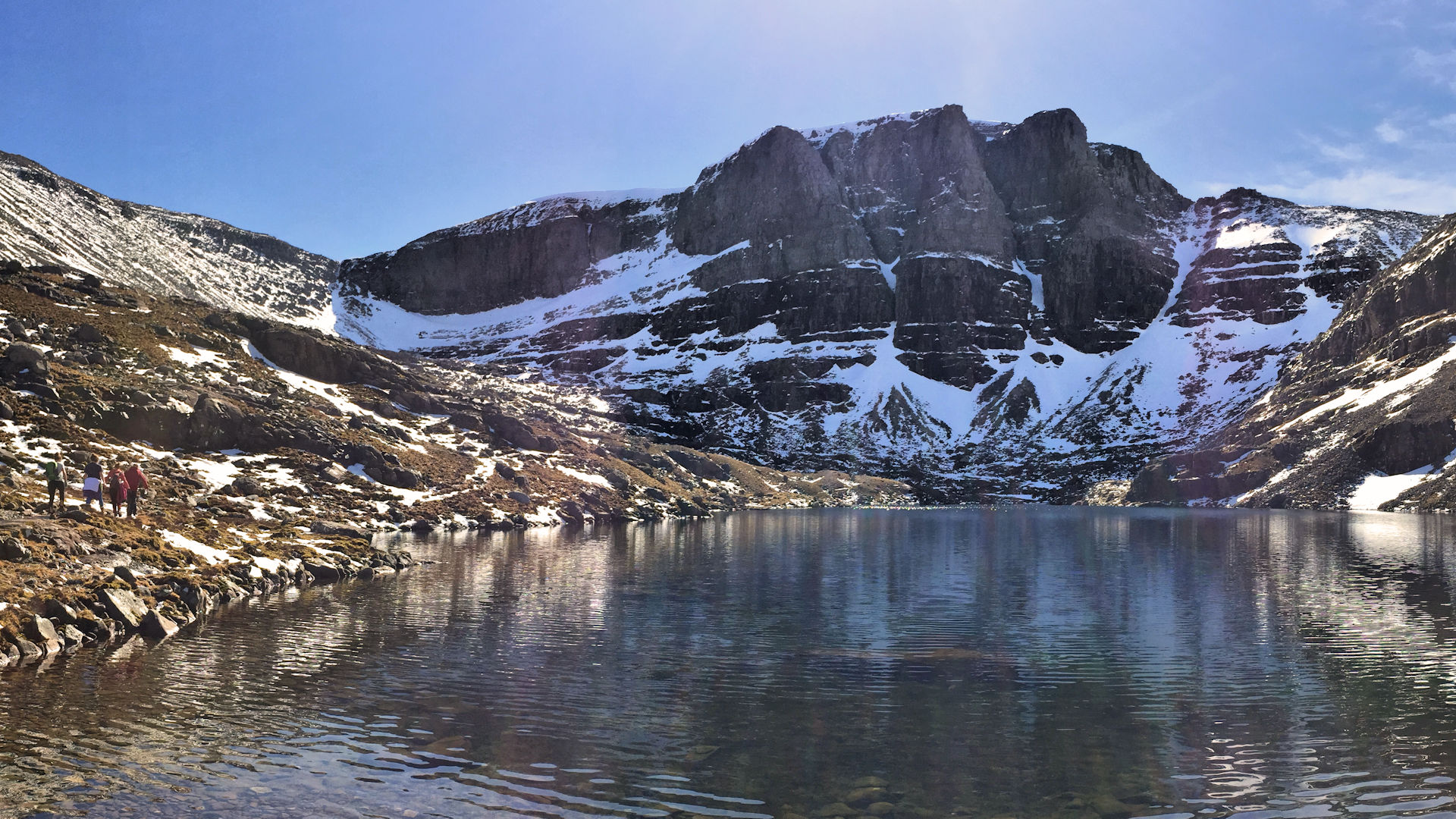
Once down onto more level ground  in Coire Mhic Fhearchair, progress involves much bounding over wet grassy ground with hidden boulders and burns. Try not to stumble as you awe at the Triple Buttress ! By the western shore of Loch Coire Mhic Fheachair, there is some wreckage of a Lancester plane which crashed in the 1950's.
Head around the northern shore of the loch to where there are some lovely spots to sit and take in the splendour of Coire Mhic Fhearchair. Cross the loch's outflow  and pick up a well constructed path at the foot of Sàil Mhòr.

On the path out, Beinn Dearg ahead
 by a junction with the Coire Dubh Mòr path. Keeping eastwards, follow the path into Coire Dubh Mòr
  and back to the roadside
  in Glen Torridon by the eastern end of Liathach, around 2km west of the start point..
On the path out, Beinn Dearg ahead
5. Detour to Sàil Mhor

The scramble on Ceum Grannda
Choinneach Mhòr and Sàil Mhòr are 'Munro Tops' on the western end of Beinn Eighe's ridge overlooking Loch Coire Mhic Fhearchair. To reach Choinneach Mhòr is a delightful detour from the main ridge, walking in the main on grass up a gentle incline. To gain Sàil Mhòr is much more commiting and involves a downward rock scramble at Grade 2.
From Coinneach Mòr's eastern summit , head westwards over a wide grass covered plateau above Coire Mhic Fhearchair for around 500m. The grass gives was to stoney ground and Coinneach Mhòr's western summit  is gained.
To begin an approach to Sàil Mhor, head further westwards from Coinneach Mhòr's western summit for a few metres to be greeted by a drop preventing progress. This rocky quartzite slant is called 'Ceum Grannda' (meaning 'the ugly step'), and looks more difficult than it actually is. The rock is quite solid and an enjoyable scramble will see you down this !
Reach the bealach between Coinneach Mhòr and Sàil Mhòr from where a hike up easy ground gains Sàil Mhòr's summit  .
.

Loch Coire Mhic Fearchair from the bealach below Sàil Mhor
Loch Coire Mhic Fearchair from the bealach below Sàil Mhor
6. Sgùrr nan Fhir Duibhe and the Black Carls

Sgùrr nan Fhir Duibhe from its eastern shoulder
Sgùrr Bàn  and Sgùrr nan Fhir Duibhe
  are 'Munro Tops' on the eastern end of Beinn Eighe's main ridge. These minor summits are gained by following Beinn Eighe's crest eastwards from Spidean Coire nan Clach and tracing a faint path on stoney ground .
Sgùrr nan Fhir Duibhe stands at the southern end of a fine little ridge called the 'Black Carls' which leads out to Creag Dhubh  and its minor northern summit
  from where fine views are to be had over Loch Maree and Slioch.
The scramble along the Black Carls is at Grade 1 and there are by-pass paths below the pinnacles. The route north of the Black Carls over Creag Dhubh's summits is straightforward following a path along a crest.
Instead of gaining Sgùrr nan Fhir Duibhe by detouring from Spidean Coire nan Clach, there are other possible approaches. A path beginning from just south of Kinlochewe follows the Allt a' Chùirn heading upstream and onto the eastern spur of Creag Dhubh. Another path begins by the Beinn Eighe Visitor Centre which stands by the roadside around 1km north-west of Kinlochewe (see Meall a' Ghiubhais and Ruadh-stac Beag route page).

Sgùrr nan Fhir Duibhe and the Black Carls from Sgùrr Ban
. Not the best of routes !Sgùrr nan Fhir Duibhe and the Black Carls from Sgùrr Ban
7. Alternative return

Returning to the bealach between Choinneach Mhòr and Spidean Coire nan Clach
Having bagged Ruadh-stac Mor, a more direct route back to the roadside can be made by returning part way along Beinn Eighe's crest. This misses out a visit to Coire Mhic Fhearchair, so perhaps a recommended route if weather turns foul.
From Ruadh-stac Mòr return along the arête above the eastern end of Coire Mhic Fhearchair and back up Choinneach Mòr's eastern rise . Retrace your steps along Beinn Eighe's centre ridge down to the bealach between Coinneach Mhòr and Spidean Coire nan Clach.
Just to the east of the lowest point on the bealach is the head of a little used scree run that drops southwards down to Coire Dubh Mòr below. The scree is perfect for a fast run downhill !
Upon reaching the bottom, hopefully intact and with a big grin on your face, cross heather and some wet ground to pick up the Coire Dubh Mòr path to follow back to the roadside.
Maps and GPX downloads »


Route profile »

Weather forecasts »
| Regional | MWIS - Northwest Highlands |
| Peak specific | Mountain Forecast.com Met Office YR.no |
| Seasonal | SAIS - Torridon Midge forecast |
Alternative and nearby routes »
Meall a' Ghiubhais and Ruadh-stac Beag | |
|
Hillwalking route up Meall a' Ghiubhais and Ruadh-stac Beag from Kinlochewe. Rugged Corbetts with tricky navigation behind Beinn Eighe in Torridon. Peaks : 2 Corbetts
Ascent : 1430m (4690ft) Distance : 18km (11m) Time : 6:55hr* | |
Liathach traverse | |
|
Traverse Liathach in Torridon, the most dramatic of the Torridon Giants, with rough routes and an optional bypass path around the Am Fasarinen Pinnacles. Peaks : 2 Munros
Ascent : 1280m (4200ft) Distance : 6km (4m) Time : 3:40hr* | |
Beinn Alligin and Beinn Dearg | |
|
Hillwalking and scrambling traverse of Beinn Alligin and Beinn Dearg in Torridon, fine ridges and a good introduction to Scottish rock. Peaks : 2 Munros, 1 Corbett
Ascent : 1250m (4100ft) Distance : 10km (6m) Time : 4:35hr* | |
Beinn a' Chearcaill from Loch Maree | |
|
A rough hillwalking route up Beinn a' Chearcaill from Loch Maree, over heather and sandstone to a plateau with views to Slioch, Torridon and over Loch Maree Peaks : 1 Fiona/Graham
Ascent : 785m (2580ft) Distance : 14km (9m) Time : 4:50hr* | |
Coulin Forest from Glen Torridon | |
|
Hillwalking route from Glen Torridon up Munros and Corbetts in Coulin Forest. Beinn Liath Mhòr, Sgòrr Ruadh, Sgùrr Dubh and Sgòrr nan Lochan Uaine. Peaks : 2 Munros, 2 Corbetts
Ascent : 1750m (5740ft) Distance : 21km (13m) Time : 8:10hr* | |
* Times shown are estimates – see timing notes on the disclaimer page for more information.

