

Ganu Mor, Foinaven (Foinne Bheinn)
With boulderfields, ridges, crags, summits and corries, Foinaven is a magnificent mountain regardless of list status and reminiscent of Beinn Eighe in Torridon.
Ganu Mor, Foinaven (Foinne Bheinn)
| Height | 911.05m |
| Prominence | 688m |
| Meaning | white hill (big wedge) |
| Lists | Corbetts, 8 |
| Location | Srath Dionard to Strath Stack, Loch Shin to the Pentland Firth |
| Grid Ref | NC315506 |
| Lat/Lon | 58.41206, -4.88569 |
Back in the early 1990's Foinaven's summit, Ganu Mòr was given a spot height of 915m by the Ordnance Survey, therefore briefly becoming a Munro. The local hotels braced themselves for an influx of Munro-baggers, before Foinaven's summit was quickly given a revised height of 913m (which has since been revised further).
Foinaven is a formidable and complex mountain topped with quartzite boulders and with many ridges, coires and spurs. Foinaven's summit, Ganu Mòr is near the northern end of the mountain and the nearest approach point would be from the A838 north-west of Rhiconich. However, most of Foinaven's splendid character would be missed from this angle.
Approaches from Loch Stack to the south may be longer, but Foinaven's complexity can be better appreciated. Another advantage of approaching from this direction, is that other fine mountain peaks can be added in to make for a superb long hillwalking day.
Fine tracks give access to Foinaven and its neighbours, however higher up the ground is very rough and often pathless. Foinaven is therefore not recommended for inexperienced walkers.
Routes up Ganu Mor, Foinaven
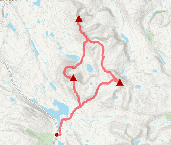
Foinaven and Arkle from Loch Stack | |

|
Hillwalking route up Foinaven and Arkle from Stack Lodge. Estate tracks give way to steep, rough ground leading to the narrow crests of these superb peaks. Peaks : 2 Corbetts
Ascent : 2175m (7140ft) Distance : 31km (19m) Time : 11:30hr |
Reay Forest Corbetts from Lone | |
|
Hillwalking route up Foinaven, Meall Hòrn and Arkle from Achfary. A demanding circular over three Reay Forest Corbetts on rough crests and complex terrain. Peaks : 3 Corbetts
Ascent : 2550m (8370ft) Distance : 31km (19m) Time : 12hr |


