

Ben Stack from Achfary
Hillwalking route up Ben Stack from Achfary at the southern end of Loch Stack with option of alternative start from Lochstack Lodge.
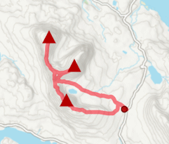
Route outline
| Fionas | ||||
| Ascent | 710m (2320ft) | |||
| Distance | 8km (5m) | |||
| Time | 3:10hr | |||
| Start | Achfary, Loch Stack Grid Ref : NC297402 | |||
| Finish | Lochstack Lodge, Laxford Grid Ref : NC265437 | |||
| Terrain |
| |||
| Nav |
| |||
| Effort |
| |||
| Scenery |
| |||


Ben Stack rises sharply above the lochan-studded moorland south of Loch Stack, a Schiehallion-shaped hill whose grassy slopes give a swift and enjoyable ascent. Though modest in height, it rewards with sweeping views over Arkle, Foinaven and the far northwest Highlands.
Show map

Route description
1. Getting to Achfary

Approaching Achfary and Ben Stack from Loch More
In the far north of Scotland, Foinaven, Arkle and Meall Hòrn lie in the vast area of Reay Forest over looking the A838 travelling from Lairg to Laxford Bridge and Rhiconich.
A few miles south-east of Laxford Bridge is Loch Stack and at its southern end, just north of the hamlet of Achfary, there is a private road heading northwards. This is where the route begins and there is ample parking at the junction of this road or by the bridge over the inflow to Loch Stack.
The alternative start (or finish) begins from 5km back up the road by the northern end of Loch Stack and close to the entrance to Lochstack Lodge where the road crosses a cattle-grid.
2. Ben Stack

On the way up Ben Stack, cloud lifting over Foinaven and Arkle
From the roadside, walk a short way south along the road to the next passing place. On the west side of the road, a rough track heads northwest to a mast by the edge of forestry. A faint path can then be followed and jogged steadily uphill until it fades at around 350m  .
.
From this point, continue northwest on open grassy slopes, weaving between rocky gneiss outcrops, to reach a minor summit at about 550m  . A clearer path then emerges, guiding the way along the ridge towards the main summit. The gradient steepens for the final 200m of ascent.

On the summit of Ben Stack
 , not the nearby trig point. A little mast with solar power stands close by. The views are superb, spanning the intricate ridges of Foinaven, Meall Horn, and Arkle, as well as the loch-dotted wilds of Sutherland. Descend by retracing the route of ascent, enjoying runnable slopes back to the roadside.
On the summit of Ben Stack
3. Alternative route from Lochstack Lodge

Lochstack Lodge
Instead of retracing steps back to Achfary, Ben Stack can also be descended via its north-western shoulder to Lochstack Lodge. In fact, if considering this option, it’s often better to ascend by the northwest shoulder and then descend towards Achfary. Note that this variation requires either transport from Lochstack Lodge or an additional 5km walk back.
Starting close to Lochstack Lodge by a cattle grid and gate, follow a stalker’s path that climbs gently until a junction  just above Loch na Seilge is reached.

Looking from Ben Stack's summit down its northwestern shoulder
 .
.Looking from Ben Stack's summit down its northwestern shoulder
Route profile »

Maps and GPX downloads »


|
Download GPX of route |

|
Open route in OS Maps |
The map images above link to items on Amazon. A small commission is earned on any map purchased which helps fund the operating costs of this website.
Weather forecasts »
| Regional | MWIS - Northwest Highlands |
| Peak specific | Mountain Forecast.com Met Office YR.no |
| Seasonal | Midge forecast |
Alternative and nearby routes »
Foinaven and Arkle from Loch Stack | |

|
Hillwalking route up Foinaven and Arkle from Stack Lodge. Estate tracks give way to steep, rough ground leading to the narrow crests of these superb peaks. Peaks : 2 Corbetts
Ascent : 2175m (7140ft) Distance : 31km (19m) Time : 11:30hr |
Meallan Liath Coire Mhic Dhughaill and Meall Horn | |

|
Hillwalking route from Loch More over Meallan Liath Coire Mhic Dhughaill and Meall Horn, two fine Corbetts in the remote Reay Forest. Peaks : 2 Corbetts, 1 Fiona
Ascent : 1600m (5250ft) Distance : 22km (14m) Time : 8:10hr |
Beinn Leoid, Meallan a' Chuail and Meall an Fheur Loch | |

|
Hillwalking route up Beinn Leòid from Loch Merkland. Using fine stalker’s paths, this outing also bags Meallan a’ Chuail and Meall an Fheur Loch. Peaks : 1 Corbett, 2 Fionas
Ascent : 1175m (3850ft) Distance : 17km (11m) Time : 6:10hr |
Quinag from above Loch Assynt | |
|
Hillwalking route bagging Spidean Coinich, Sàil Gharbh and Sàil Ghorm on Quinag. A superb route covering all 3 Corbett summits on this rugged massif. Peaks : 3 Corbetts
Ascent : 1150m (3770ft) Distance : 13km (8m) Time : 5:10hr |
Ben Hee from Loch Merkland | |

|
Hillwalking route up Ben Hee from West Merkland. A direct but rough line over pathless, bouldery terrain gains this domed hill above Loch Merkland. Peaks : 1 Corbett
Ascent : 850m (2790ft) Distance : 14km (9m) Time : 4:55hr |


